
 Backend-Entwicklung
Python-Tutorial
So verwenden Sie Python, um den detaillierten Standort zu ermitteln, an dem das Foto aufgenommen wurde
Backend-Entwicklung
Python-Tutorial
So verwenden Sie Python, um den detaillierten Standort zu ermitteln, an dem das Foto aufgenommen wurde
So verwenden Sie Python, um den detaillierten Standort zu ermitteln, an dem das Foto aufgenommen wurde

一.引言
我们的朋友给我们发来一张照片我们如何获取到她的位置呢?
用手机拍照会带着GPS信息,原来没注意过这个,因此查看下并使用代码获取照片里的GPS信息
查看图片文件属性
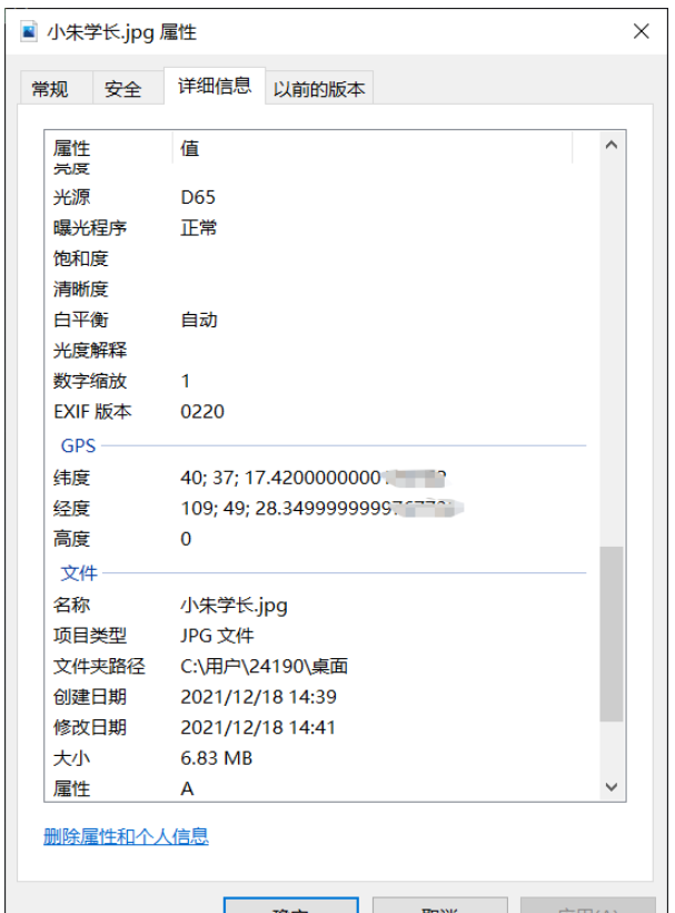
1.读取照片信息,获取坐标
ExifRead
Python library to extract EXIF data from tiff and jpeg files.
安装
pip install exifread
读取GPS
import exifread
import re

def read():
    GPS = {}
    date = ''
    f = open("C:\\Users\\24190\\Desktop\\小朱学长.jpg",'rb')
    contents = exifread.process_file(f)
    for key in contents:
        if key == "GPS GPSLongitude":
            print("经度 =", contents[key],contents['GPS GPSLatitudeRef'])
        elif key =="GPS GPSLatitude":
            print("纬度 =",contents[key],contents['GPS GPSLongitudeRef'])
        #print(contents)
read()运行

我们得到了一个简易的gps地址
如果想要读取全部的拍摄信息:
# 读取照片的GPS经纬度信息
def find_GPS_image(pic_path):
        GPS = {}
        date = ''
        with open(pic_path, 'rb') as f:
                tags = exifread.process_file(f)
                for tag, value in tags.items():
                        # 纬度
                        if re.match('GPS GPSLatitudeRef', tag):
                                GPS['GPSLatitudeRef'] = str(value)
                        # 经度
                        elif re.match('GPS GPSLongitudeRef', tag):
                                GPS['GPSLongitudeRef'] = str(value)
                        # 海拔
                        elif re.match('GPS GPSAltitudeRef', tag):
                                GPS['GPSAltitudeRef'] = str(value)
                        elif re.match('GPS GPSLatitude', tag):
                                try:
                                        match_result = re.match('\[(\w*),(\w*),(\w.*)/(\w.*)\]', str(value)).groups()
                                        GPS['GPSLatitude'] = int(match_result[0]), int(match_result[1]), int(match_result[2])
                                except:
                                        deg, min, sec = [x.replace(' ', '') for x in str(value)[1:-1].split(',')]
                                        GPS['GPSLatitude'] = latitude_and_longitude_convert_to_decimal_system(deg, min, sec)
                        elif re.match('GPS GPSLongitude', tag):
                                try:
                                        match_result = re.match('\[(\w*),(\w*),(\w.*)/(\w.*)\]', str(value)).groups()
                                        GPS['GPSLongitude'] = int(match_result[0]), int(match_result[1]), int(match_result[2])
                                except:
                                        deg, min, sec = [x.replace(' ', '') for x in str(value)[1:-1].split(',')]
                                        GPS['GPSLongitude'] = latitude_and_longitude_convert_to_decimal_system(deg, min, sec)
                        elif re.match('GPS GPSAltitude', tag):
                                GPS['GPSAltitude'] = str(value)
                        elif re.match('.*Date.*', tag):
                                date = str(value)
return {'GPS_information': GPS, 'date_information': date}2.通过baidu Map的API将GPS信息转换成地址。
众所周知gps和百度的经纬度会有误差,那么我们需要调用百度转换接口,这个百度目前没有开源。
# 通过baidu Map的API将GPS信息转换成地址。
def find_address_from_GPS(GPS):
        """
        使用Geocoding API把经纬度坐标转换为结构化地址。
        :param GPS:
        :return:
        """
        secret_k ey = 'XXX'
        if not GPS['GPS_information']:
                return '该照片无GPS信息'
        lat, lng = GPS['GPS_information']['GPSLatitude'], GPS['GPS_information']['GPSLongitude']
        baidu_map_api = "http://api.map.baidu.com/geocoder/v2/?ak={0}&callback=renderReverse&location={1},{2}s&output=json&pois=0".format(
                secret_key, lat, lng)
        response = requests.get(baidu_map_api)
        content = response.text.replace("renderReverse&&renderReverse(", "")[:-1]
        print(content)
        baidu_map_address = json.loads(content)
        formatted_address = baidu_map_address["result"]["formatted_address"]
        province = baidu_map_address["result"]["addressComponent"]["province"]
        city = baidu_map_address["result"]["addressComponent"]["city"]
        district = baidu_map_address["result"]["addressComponent"]["district"]
        location = baidu_map_address["result"]["sematic_description"]
return formatted_address, province, city, district, location然后在主函数输出:
二.源码附上!!!
# coding=utf-8
import exifread
import re
import json
import requests
import os
# 转换经纬度格式
def latitude_and_longitude_convert_to_decimal_system(*arg):
"""
经纬度转为小数, param arg:
:return: 十进制小数
"""
return float(arg[0]) + ((float(arg[1]) + (float(arg[2].split('/')[0]) / float(arg[2].split('/')[-1]) / 60)) / 60)
# 读取照片的GPS经纬度信息
def find_GPS_image(pic_path):
GPS = {}
date = ''
with open(pic_path, 'rb') as f:
tags = exifread.process_file(f)
for tag, value in tags.items():
# 纬度
if re.match('GPS GPSLatitudeRef', tag):
GPS['GPSLatitudeRef'] = str(value)
# 经度
elif re.match('GPS GPSLongitudeRef', tag):
GPS['GPSLongitudeRef'] = str(value)
# 海拔
elif re.match('GPS GPSAltitudeRef', tag):
GPS['GPSAltitudeRef'] = str(value)
elif re.match('GPS GPSLatitude', tag):
try:
match_result = re.match('\[(\w*),(\w*),(\w.*)/(\w.*)\]', str(value)).groups()
GPS['GPSLatitude'] = int(match_result[0]), int(match_result[1]), int(match_result[2])
except:
deg, min, sec = [x.replace(' ', '') for x in str(value)[1:-1].split(',')]
GPS['GPSLatitude'] = latitude_and_longitude_convert_to_decimal_system(deg, min, sec)
elif re.match('GPS GPSLongitude', tag):
try:
match_result = re.match('\[(\w*),(\w*),(\w.*)/(\w.*)\]', str(value)).groups()
GPS['GPSLongitude'] = int(match_result[0]), int(match_result[1]), int(match_result[2])
except:
deg, min, sec = [x.replace(' ', '') for x in str(value)[1:-1].split(',')]
GPS['GPSLongitude'] = latitude_and_longitude_convert_to_decimal_system(deg, min, sec)
elif re.match('GPS GPSAltitude', tag):
GPS['GPSAltitude'] = str(value)
elif re.match('.*Date.*', tag):
date = str(value)
return {'GPS_information': GPS, 'date_information': date}
# 通过baidu Map的API将GPS信息转换成地址。
def find_address_from_GPS(GPS):
"""
使用Geocoding API把经纬度坐标转换为结构化地址。
:param GPS:
:return:
"""
secret_ke y = 'zbLsuDDL4CS2U0M4KezOZZbGUY9iWtVf'
if not GPS['GPS_information']:
return '该照片无GPS信息'
lat, lng = GPS['GPS_information']['GPSLatitude'], GPS['GPS_information']['GPSLongitude']
baidu_map_api = "http://api.map.baidu.com/geocoder/v2/?ak={0}&callback=renderReverse&location={1},{2}s&output=json&pois=0".format(
secret_key, lat, lng)
response = requests.get(baidu_map_api)
content = response.text.replace("renderReverse&&renderReverse(", "")[:-1]
print(content)
baidu_map_address = json.loads(content)
formatted_address = baidu_map_address["result"]["formatted_address"]
province = baidu_map_address["result"]["addressComponent"]["province"]
city = baidu_map_address["result"]["addressComponent"]["city"]
district = baidu_map_address["result"]["addressComponent"]["district"]
location = baidu_map_address["result"]["sematic_description"]
return formatted_address, province, city, district, location
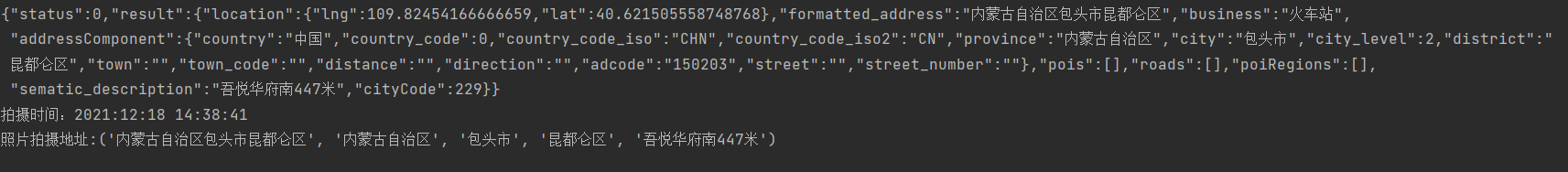
if __name__ == '__main__':
GPS_info = find_GPS_image(pic_path='小朱学长.jpg')
address = find_address_from_GPS(GPS=GPS_info)
print("拍摄时间:" + GPS_info.get("date_information"))
print('照片拍摄地址:' + str(address))注意事项
1.照片的地址信息等,一般的手机相机默认是打开的。
2.微信和QQ里面发送原图,信息都会完整的保留下来。
3.代码里面需要处理在照片我放到了代码的同文件夹下,所以没有写路径,大家可以自己写路径,或者放到于代码相同的路径下即可。
Das obige ist der detaillierte Inhalt vonSo verwenden Sie Python, um den detaillierten Standort zu ermitteln, an dem das Foto aufgenommen wurde. Für weitere Informationen folgen Sie bitte anderen verwandten Artikeln auf der PHP chinesischen Website!

Heiße KI -Werkzeuge

Undresser.AI Undress
KI-gestützte App zum Erstellen realistischer Aktfotos

AI Clothes Remover
Online-KI-Tool zum Entfernen von Kleidung aus Fotos.

Undress AI Tool
Ausziehbilder kostenlos

Clothoff.io
KI-Kleiderentferner

AI Hentai Generator
Erstellen Sie kostenlos Ai Hentai.

Heißer Artikel
Heiße Werkzeuge

Notepad++7.3.1
Einfach zu bedienender und kostenloser Code-Editor

SublimeText3 chinesische Version
Chinesische Version, sehr einfach zu bedienen

Senden Sie Studio 13.0.1
Leistungsstarke integrierte PHP-Entwicklungsumgebung

Dreamweaver CS6
Visuelle Webentwicklungstools

SublimeText3 Mac-Version
Codebearbeitungssoftware auf Gottesniveau (SublimeText3)
Heiße Themen


 Wie kann man Node.js oder Python -Dienste in Lampenarchitektur effizient integrieren?
Apr 01, 2025 pm 02:48 PM
Wie kann man Node.js oder Python -Dienste in Lampenarchitektur effizient integrieren?
Apr 01, 2025 pm 02:48 PM
Viele Website -Entwickler stehen vor dem Problem der Integration von Node.js oder Python Services unter der Lampenarchitektur: Die vorhandene Lampe (Linux Apache MySQL PHP) Architekturwebsite benötigt ...
 Was ist der Grund, warum Pipeline persistente Speicherdateien bei der Verwendung von Scapy Crawler nicht geschrieben werden kann?
Apr 01, 2025 pm 04:03 PM
Was ist der Grund, warum Pipeline persistente Speicherdateien bei der Verwendung von Scapy Crawler nicht geschrieben werden kann?
Apr 01, 2025 pm 04:03 PM
Bei der Verwendung von Scapy Crawler kann der Grund, warum Pipeline persistente Speicherdateien nicht geschrieben werden kann? Diskussion beim Lernen, Scapy Crawler für Data Crawler zu verwenden, begegnen Sie häufig auf eine ...
 Was ist der Grund, warum der Python -Prozesspool gleichzeitige TCP -Anfragen behandelt und den Kunden dazu bringt, stecken zu bleiben?
Apr 01, 2025 pm 04:09 PM
Was ist der Grund, warum der Python -Prozesspool gleichzeitige TCP -Anfragen behandelt und den Kunden dazu bringt, stecken zu bleiben?
Apr 01, 2025 pm 04:09 PM
Python Process Pool verarbeitet gleichzeitige TCP -Anfragen, die dazu führen, dass der Client stecken bleibt. Bei der Verwendung von Python für die Netzwerkprogrammierung ist es entscheidend, gleichzeitige TCP -Anforderungen effizient zu verarbeiten. ...
 Wie kann ich die ursprünglichen Funktionen betrachten, die von Python Functools.Partial Object in intern eingekapselt sind?
Apr 01, 2025 pm 04:15 PM
Wie kann ich die ursprünglichen Funktionen betrachten, die von Python Functools.Partial Object in intern eingekapselt sind?
Apr 01, 2025 pm 04:15 PM
Erforschen Sie tief die Betrachtungsmethode von Python Functools.Partialial Object in functools.Partial mit Python ...
 Wie löste ich das Problem der Berechtigungen beim Betrachten der Python -Version in Linux Terminal?
Apr 01, 2025 pm 05:09 PM
Wie löste ich das Problem der Berechtigungen beim Betrachten der Python -Version in Linux Terminal?
Apr 01, 2025 pm 05:09 PM
Lösung für Erlaubnisprobleme beim Betrachten der Python -Version in Linux Terminal Wenn Sie versuchen, die Python -Version in Linux Terminal anzuzeigen, geben Sie Python ein ...
 Python Cross-Platform Desktop-Anwendungsentwicklung: Welche GUI-Bibliothek ist die beste für Sie?
Apr 01, 2025 pm 05:24 PM
Python Cross-Platform Desktop-Anwendungsentwicklung: Welche GUI-Bibliothek ist die beste für Sie?
Apr 01, 2025 pm 05:24 PM
Auswahl der Python-plattformübergreifenden Desktop-Anwendungsentwicklungsbibliothek Viele Python-Entwickler möchten Desktop-Anwendungen entwickeln, die sowohl auf Windows- als auch auf Linux-Systemen ausgeführt werden können ...
 Python Hourglass Graph Drawing: Wie vermeiden Sie variable undefinierte Fehler?
Apr 01, 2025 pm 06:27 PM
Python Hourglass Graph Drawing: Wie vermeiden Sie variable undefinierte Fehler?
Apr 01, 2025 pm 06:27 PM
Erste Schritte mit Python: Hourglas -Grafikzeichnung und Eingabeüberprüfung In diesem Artikel wird das Problem der Variablendefinition gelöst, das von einem Python -Anfänger im Hourglass -Grafikzeichnungsprogramm auftritt. Code...
 Wie kann ich große Produktdatensätze in Python effizient zählen und sortieren?
Apr 01, 2025 pm 08:03 PM
Wie kann ich große Produktdatensätze in Python effizient zählen und sortieren?
Apr 01, 2025 pm 08:03 PM
Datenkonvertierung und Statistik: Effiziente Verarbeitung großer Datensätze In diesem Artikel werden ausführlich das Umwandeln einer Datenliste in eine andere enthält ...
