 Technology peripherals
 AI
AI
 Virtual-real domain adaptation method for autonomous driving lane detection and classification
Virtual-real domain adaptation method for autonomous driving lane detection and classification
arXiv paper "Sim-to-Real Domain Adaptation for Lane Detection and Classification in Autonomous Driving", May 2022, work at the University of Waterloo, Canada.

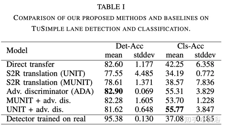
While supervised detection and classification frameworks for autonomous driving require large annotated datasets, Unsupervised Domain Adaptation (UDA) driven by synthetic data generated by illuminating real simulated environments , Unsupervised Domain Adaptation) method is a low-cost, less time-consuming solution. This paper proposes a UDA scheme of adversarial discriminative and generative methods for lane line detection and classification applications in autonomous driving.
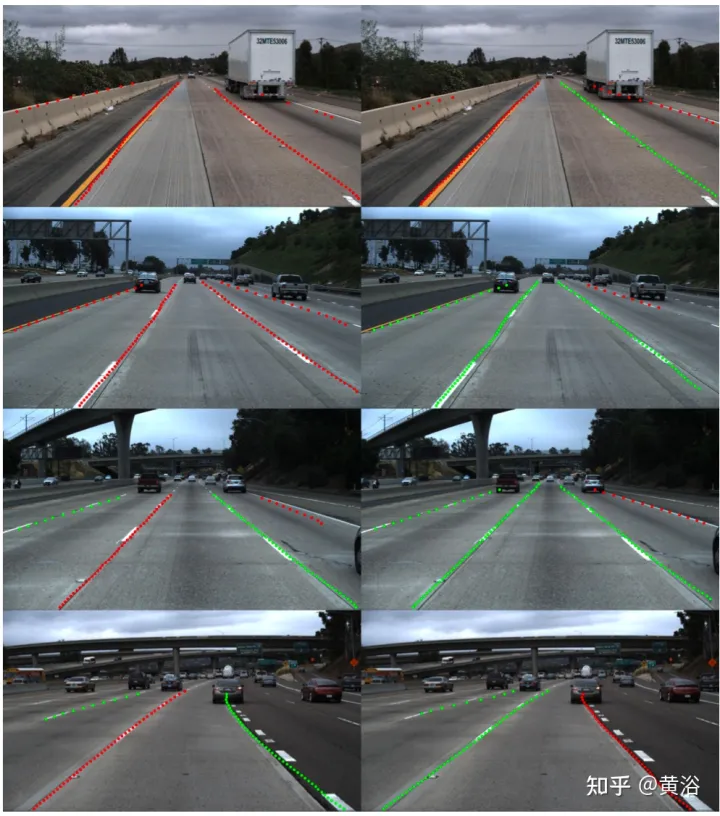
Also introduces the Simulanes dataset generator, which takes advantage of CARLA's huge traffic scenes and weather conditions to create a natural synthetic dataset. The proposed UDA framework takes the labeled synthetic dataset as the source domain, while the target domain is the unlabeled real data. Use adversarial generation and feature discriminator to debug the learning model and predict the lane location and category of the target domain. Evaluation is performed with real and synthetic datasets.
The open source UDA framework is atgithubcom/anita-hu/sim2real-lane-detection, and the data set generator is at github.com/anita-hu/simulanes.
Real-world driving is diverse, with varying traffic conditions, weather, and surrounding environments. Therefore, the diversity of simulation scenarios is crucial to the good adaptability of the model in the real world. There are many open source simulators for autonomous driving, namely CARLA and LGSVL. This article chooses CARLA to generate the simulation data set. In addition to the flexible Python API, CARLA also contains rich pre-drawn map content covering urban, rural and highway scenes.
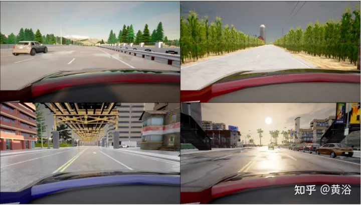
Simulation data generator Simulanes generates a variety of simulation scenarios in urban, rural and highway environments, including 15 lane categories and dynamic weather. The figure shows samples from the synthetic dataset. Pedestrian and vehicle participants are randomly generated and placed on the map, increasing the difficulty of the dataset through occlusion. According to the TuSimple and CULane datasets, the maximum number of lanes near the vehicle is limited to 4, and row anchors are used as labels.

Since the CARLA simulator does not directly provide lane location labels, CARLA's waypoint system is used to generate labels. A CARLA waypoint is a predefined position for the vehicle autopilot to follow, located in the center of the lane. In order to obtain the lane position label, the waypoint of the current lane is moved left and right by W/2, where W is the lane width given by the simulator. These moved waypoints are then projected into the camera coordinate system and spline-fitted to generate labels along predetermined row anchor points. The class label is given by the simulator and is one of 15 classes.
To generate a dataset with N frames, divide N evenly across all available maps. From the default CARLA map, towns 1, 3, 4, 5, 7 and 10 were used, while towns 2 and 6 were not used due to differences between the extracted lane position labels and the lane positions of the image. For each map, vehicle participants are spawned at random locations and move randomly. Dynamic weather is achieved by smoothly changing the position of the sun as a sinusoidal function of time and occasionally producing storms, which affect the appearance of the environment through variables such as cloud cover, water volume and standing water. To avoid saving multiple frames at the same location, check if the vehicle has moved from the previous frame's location and regenerate a new vehicle if it has been stationary for too long.
When the sim-to-real algorithm is applied to lane detection, an end-to-end approach is adopted and the Ultra-Fast-Lane-Detection (UFLD) model is used as the basic network. UFLD was chosen because its lightweight architecture can achieve 300 frames/second at the same input resolution while achieving performance comparable to state-of-the-art methods. UFLD formulates the lane detection task as a row-based selection method, where each lane is represented by a series of horizontal positions of predefined rows, i.e., row anchors. For each row anchor, the position is divided into w grid cells. For the i-th lane and j-th row anchor, location prediction becomes a classification problem, where the model outputs the probability Pi,j of selecting (w 1) grid cell. The additional dimension in the output is no lanes.
UFLD proposes an auxiliary segmentation branch to aggregate features at multiple scales to model local features. This is only used during training. With the UFLD method, cross-entropy loss is used for segmentation loss Lseg. For lane classification, a small branch of the fully connected (FC) layer is added to receive the same features as the FC layer for lane position prediction. The lane classification loss Lcls also uses cross-entropy loss.
In order to alleviate the domain drift problem of UDA settings, UNIT ("Unsupervised Image-to-Image Translation Networks", NIPS, 2017) & MUNIT## are adopted #("Multimodal unsupervised image-to-image translation," ECCV 2018) adversarial generation method, and adversarial discriminative method using feature discriminator. As shown in the figure: an adversarial generation method (A) and an adversarial discrimination method (B) are proposed. UNIT and MUNIT are represented in (A), which shows the generator input for image translation. Additional style inputs to MUNIT are shown with dashed blue lines. For simplicity, the MUNIT-style encoder output is omitted as it is not used for image translation.


The above is the detailed content of Virtual-real domain adaptation method for autonomous driving lane detection and classification. For more information, please follow other related articles on the PHP Chinese website!

Hot AI Tools

Undresser.AI Undress
AI-powered app for creating realistic nude photos

AI Clothes Remover
Online AI tool for removing clothes from photos.

Undress AI Tool
Undress images for free

Clothoff.io
AI clothes remover

AI Hentai Generator
Generate AI Hentai for free.

Hot Article

Hot Tools

Notepad++7.3.1
Easy-to-use and free code editor

SublimeText3 Chinese version
Chinese version, very easy to use

Zend Studio 13.0.1
Powerful PHP integrated development environment

Dreamweaver CS6
Visual web development tools

SublimeText3 Mac version
God-level code editing software (SublimeText3)

Hot Topics
 1376
1376
 52
52
 Use ddrescue to recover data on Linux
Mar 20, 2024 pm 01:37 PM
DDREASE is a tool for recovering data from file or block devices such as hard drives, SSDs, RAM disks, CDs, DVDs and USB storage devices. It copies data from one block device to another, leaving corrupted data blocks behind and moving only good data blocks. ddreasue is a powerful recovery tool that is fully automated as it does not require any interference during recovery operations. Additionally, thanks to the ddasue map file, it can be stopped and resumed at any time. Other key features of DDREASE are as follows: It does not overwrite recovered data but fills the gaps in case of iterative recovery. However, it can be truncated if the tool is instructed to do so explicitly. Recover data from multiple files or blocks to a single
 Open source! Beyond ZoeDepth! DepthFM: Fast and accurate monocular depth estimation!
Apr 03, 2024 pm 12:04 PM
0.What does this article do? We propose DepthFM: a versatile and fast state-of-the-art generative monocular depth estimation model. In addition to traditional depth estimation tasks, DepthFM also demonstrates state-of-the-art capabilities in downstream tasks such as depth inpainting. DepthFM is efficient and can synthesize depth maps within a few inference steps. Let’s read about this work together ~ 1. Paper information title: DepthFM: FastMonocularDepthEstimationwithFlowMatching Author: MingGui, JohannesS.Fischer, UlrichPrestel, PingchuanMa, Dmytr
 How to solve the long tail problem in autonomous driving scenarios?
Jun 02, 2024 pm 02:44 PM
Yesterday during the interview, I was asked whether I had done any long-tail related questions, so I thought I would give a brief summary. The long-tail problem of autonomous driving refers to edge cases in autonomous vehicles, that is, possible scenarios with a low probability of occurrence. The perceived long-tail problem is one of the main reasons currently limiting the operational design domain of single-vehicle intelligent autonomous vehicles. The underlying architecture and most technical issues of autonomous driving have been solved, and the remaining 5% of long-tail problems have gradually become the key to restricting the development of autonomous driving. These problems include a variety of fragmented scenarios, extreme situations, and unpredictable human behavior. The "long tail" of edge scenarios in autonomous driving refers to edge cases in autonomous vehicles (AVs). Edge cases are possible scenarios with a low probability of occurrence. these rare events
 Google is ecstatic: JAX performance surpasses Pytorch and TensorFlow! It may become the fastest choice for GPU inference training
Apr 01, 2024 pm 07:46 PM
The performance of JAX, promoted by Google, has surpassed that of Pytorch and TensorFlow in recent benchmark tests, ranking first in 7 indicators. And the test was not done on the TPU with the best JAX performance. Although among developers, Pytorch is still more popular than Tensorflow. But in the future, perhaps more large models will be trained and run based on the JAX platform. Models Recently, the Keras team benchmarked three backends (TensorFlow, JAX, PyTorch) with the native PyTorch implementation and Keras2 with TensorFlow. First, they select a set of mainstream
 Slow Cellular Data Internet Speeds on iPhone: Fixes
May 03, 2024 pm 09:01 PM
Facing lag, slow mobile data connection on iPhone? Typically, the strength of cellular internet on your phone depends on several factors such as region, cellular network type, roaming type, etc. There are some things you can do to get a faster, more reliable cellular Internet connection. Fix 1 – Force Restart iPhone Sometimes, force restarting your device just resets a lot of things, including the cellular connection. Step 1 – Just press the volume up key once and release. Next, press the Volume Down key and release it again. Step 2 – The next part of the process is to hold the button on the right side. Let the iPhone finish restarting. Enable cellular data and check network speed. Check again Fix 2 – Change data mode While 5G offers better network speeds, it works better when the signal is weaker
 The vitality of super intelligence awakens! But with the arrival of self-updating AI, mothers no longer have to worry about data bottlenecks
Apr 29, 2024 pm 06:55 PM
I cry to death. The world is madly building big models. The data on the Internet is not enough. It is not enough at all. The training model looks like "The Hunger Games", and AI researchers around the world are worrying about how to feed these data voracious eaters. This problem is particularly prominent in multi-modal tasks. At a time when nothing could be done, a start-up team from the Department of Renmin University of China used its own new model to become the first in China to make "model-generated data feed itself" a reality. Moreover, it is a two-pronged approach on the understanding side and the generation side. Both sides can generate high-quality, multi-modal new data and provide data feedback to the model itself. What is a model? Awaker 1.0, a large multi-modal model that just appeared on the Zhongguancun Forum. Who is the team? Sophon engine. Founded by Gao Yizhao, a doctoral student at Renmin University’s Hillhouse School of Artificial Intelligence.
 The U.S. Air Force showcases its first AI fighter jet with high profile! The minister personally conducted the test drive without interfering during the whole process, and 100,000 lines of code were tested for 21 times.
May 07, 2024 pm 05:00 PM
Recently, the military circle has been overwhelmed by the news: US military fighter jets can now complete fully automatic air combat using AI. Yes, just recently, the US military’s AI fighter jet was made public for the first time and the mystery was unveiled. The full name of this fighter is the Variable Stability Simulator Test Aircraft (VISTA). It was personally flown by the Secretary of the US Air Force to simulate a one-on-one air battle. On May 2, U.S. Air Force Secretary Frank Kendall took off in an X-62AVISTA at Edwards Air Force Base. Note that during the one-hour flight, all flight actions were completed autonomously by AI! Kendall said - "For the past few decades, we have been thinking about the unlimited potential of autonomous air-to-air combat, but it has always seemed out of reach." However now,
 nuScenes' latest SOTA | SparseAD: Sparse query helps efficient end-to-end autonomous driving!
Apr 17, 2024 pm 06:22 PM
Written in front & starting point The end-to-end paradigm uses a unified framework to achieve multi-tasking in autonomous driving systems. Despite the simplicity and clarity of this paradigm, the performance of end-to-end autonomous driving methods on subtasks still lags far behind single-task methods. At the same time, the dense bird's-eye view (BEV) features widely used in previous end-to-end methods make it difficult to scale to more modalities or tasks. A sparse search-centric end-to-end autonomous driving paradigm (SparseAD) is proposed here, in which sparse search fully represents the entire driving scenario, including space, time, and tasks, without any dense BEV representation. Specifically, a unified sparse architecture is designed for task awareness including detection, tracking, and online mapping. In addition, heavy


