

How to make self-driving cars 'know the road'

Just like human walking, self-driving cars also need to have independent thinking and the ability to judge and make decisions about the traffic environment if they want to complete the travel process. With the improvement of advanced assisted driving system technology, the safety of drivers driving cars continues to improve, and the degree of driver participation in driving decision-making is gradually reduced. Autonomous driving is getting closer and closer to us.
Self-driving cars, also known as driverless cars, are essentially highly intelligent robots that can complete travel behaviors with only driver assistance or without driver operation at all. Autonomous driving is mainly realized through the perception layer, decision-making layer and execution layer. As an automated vehicle, autonomous vehicles can use additional radar (millimetre-wave radar, lidar), vehicle cameras, global navigation satellite systems (GNSS), real-time Hardware devices such as dynamic (PTK) and inertial measurement unit (IMU) sense the traffic environment and judge the detected traffic environment. The self-driving car can make behavioral decisions and path planning based on the detected traffic environment, and then send signals to the execution unit commands to control the driving of self-driving cars.

The realization of self-driving cars is not as simple as we imagined. If we want to make self-driving cars reach the driving ability of experienced drivers, in addition to making self-driving cars able to "see In addition to "knowing clearly" (perception layer), "thinking clearly" (decision-making layer), and "moving forward" (execution layer), we also need to "know the road". High-precision maps are the magic weapon for self-driving cars to "know the road" Got it!
Just like how people use map navigation when arriving in a strange city, self-driving cars also need to solve problems such as where to go, how to go, and how to go if they want to achieve autonomous driving. After giving travel instructions to self-driving cars, the first thing to do is to plan the road. The navigation maps used by humans pay more attention to information such as street names and paths, and only record data such as road shape, slope, curvature, paving, direction, etc. Human beings can understand the travel routes they need based on this information. Different from navigation maps used by humans, high-precision maps for self-driving cars cover more and more complete information.
High-precision map is a kind of accuracy that can reach centimeter level (the accuracy of navigation maps used by humans is only meter level), providing high-precision, high-dimensional, high-rich, richer elements and faster update frequency. Electronic maps with high freshness can provide beyond-line-of-sight environment perception and lane-level optimal path planning, which can ensure the safety of autonomous vehicles during driving. In addition to the information covered by human navigation maps, high-precision maps also add data related to lane attributes, such as lane line type, lane width, etc., as well as overhead objects, guardrails, road edge information, and roadside obstacles. A large amount of data such as objects (trees, trash cans, telephone poles, etc.) and roadside landmarks.
High-precision maps, as a necessary aid for autonomous vehicles to "recognize the road", contain a large amount of driving information, the most important of which is the accurate three-dimensional representation of the road network. In addition to road information, it also contains a lot of Semantic information, including the color of traffic lights, road speed limit information, vehicle turning positions, etc.
The emergence and development of high-precision maps will promote the layout of smart transportation, smart cities, and smart transportation. With the development of intelligent network technology, the importance of high-precision maps has become more and more obvious. For reaching L4, even For L3 level autonomous vehicles, the installation of high-precision maps is a necessary option. High-precision maps can plan driving paths for self-driving cars, and can provide basis for positioning, decision-making, traffic dynamic information, etc. In addition, high-precision maps can also ensure that self-driving cars detect hardware failures when the sensing hardware on the self-driving cars fails or the surrounding environment is harsh. It can drive safely, and high-precision maps can enhance beyond-visual-range perception and improve the planning capabilities of autonomous vehicles.

High-precision maps are very important for self-driving cars and have many advantages. High-precision maps can provide a priori road information and redundant positioning guarantees for self-driving cars. Unlike vehicle-mounted sensors, high-precision maps are not affected or restricted by the weather environment, detection distance, etc., and can provide safety redundancy for self-driving cars. . Since the high-precision map covers location information such as lane lines, road signs, traffic lights, etc., relevant information can be predicted and the detection accuracy and speed of the sensing hardware can be improved. For example, turning left at an intersection (under the traffic rules of driving on the right) is a self-driving car. One of the more difficult problems to solve during the research and development process is that the assistance of high-precision maps can tell autonomous vehicles which intersections can make left turns, left-turn waiting areas, where the left-turn stop lines are, etc. In addition, as part of the development of the Internet of Vehicles, high-precision maps can transmit vehicle information, traffic light status information, road traffic flow information, etc. to the cloud, thereby realizing the planning and layout of intelligent transportation.
High-precision maps need to store static and dynamic vehicle environment data and traffic environment data. If they are all placed in one layer, it will be unfavorable for production and use. Therefore, standardized layers need to be used. Each layer embodies an environmental element or traffic element, and all layers are superimposed to form a usable high-precision map. At this stage, high-precision maps can be divided into two layers, namely the static data layer and the dynamic data layer. The static data layer can be subdivided from bottom to top into three vector sub-layers: lane model, road components, road attributes, and a road. Environment feature sub-layer. The dynamic data layer is based on intelligent network technology and obtains traffic operation data in real time. Traffic management data collects real-time movement data of people and vehicles. Therefore, it can be divided into traffic operation data layer, traffic management data layer and high dynamic movement layer from bottom to top.
The production and collection of high-precision maps are very different from the navigation maps used by humans. The collection system of high-precision maps has become a "mobile measurement system". Compared with the navigation maps used by humans, high-precision maps are more Focusing on autonomous driving scenarios is an indispensable part of autonomous driving solutions. Since high-precision maps have extremely high requirements for real-time updates of data, it will be laborious and costly to completely use a collection vehicle to collect high-precision maps. A high-precision map collection vehicle is mainly equipped with lidar, vehicle-mounted cameras, Gyroscopes, data storage and computing equipment, etc., the range that a high-precision map collection vehicle can collect is extremely low. If you want to fully lay out the collection, it will be a huge cost. The compilation of high-precision maps is also very time-consuming and labor-intensive. The compilation process of high-precision maps includes map drawing, map correction, updating POI information, updating Internet user error reports, etc., which requires a lot of labor costs.
For high-precision map collection in different road environments, the labor costs and time costs required are also different. For example, there is a big difference between high-precision map collection on highways and urban roads. Compared with high-precision map collection on highways, Highways and urban roads are more open, the scenes are more complex, and they cover more traffic information. They also put forward higher requirements and challenges for autonomous driving capabilities. At this time, high-precision maps will play a more important role. High-precision maps can deconstruct complex traffic environments, transmit human travel rules in a way that autonomous vehicles can understand, divide complex travel actions into multiple small tasks, and reduce or optimize the requirements of perception hardware for traffic detection. Since the high-precision map covers the associated information of each lane, self-driving cars can predict the driving behavior of vehicles in other lanes or directions in advance, ensuring that self-driving cars can drive safely in accordance with traffic rules.
In addition to providing navigation for self-driving cars, high-precision maps also play a great role in the safe driving of self-driving cars. For example, high-precision maps can provide guidance for self-driving cars in urban tunnels, elevated areas and other environments. Assistance. In these scenarios, autonomous vehicles can use high-precision maps to achieve autonomous positioning by using traffic equipment in high-precision maps as reference points and combining sensing hardware, greatly improving the safety of autonomous driving. For traffic environments where there is no maintenance for a long time and lane lines are missing, high-precision maps can ensure that autonomous vehicles can drive within the planned lane through positioning and assistance. In extreme weather conditions such as heavy fog and snowstorms, the detection accuracy of sensing hardware will be further reduced, and high-precision maps can provide more supplementary traffic information. Changing road conditions are also one of the necessary reasons for using high-precision maps. For example, in many cities to optimize the traffic environment, tidal lanes are set up and speed limits are set on different roads. In this case, route planning can be done in advance through high-precision maps. , allowing self-driving cars to follow traffic rules.

There are still many problems in the development of high-precision maps at this stage. For example, there is no unified high-precision map platform at this stage, and high-precision map information is not shared among various parking garages. This increases the number of high-precision maps. By reducing the acquisition cost, establishing a unified data model and exchange format for high-precision maps will help reduce development time and unnecessary costs for automobile manufacturers, while ensuring that high-definition maps used by cross-brand vehicles in the future can continuously share refreshed data.
The collection cost of high-precision maps is relatively high, and the updates are also relatively slow. At this stage, there are two main technical routes for collecting surveying and mapping data for high-precision maps. One is represented by Google’s map surveying vehicle. The other is represented by Tesla's "Fleet Learning Network", which is equivalent to using mass-produced vehicles to "crowdsource" surveying and mapping tasks, mobilizing all sensors in the entire fleet to collect data, and transmit it through the cloud. The technology is uploaded to a central database, and ultimately every vehicle is a map data contributor and recipient.
Changes in the traffic environment, such as road upgrades and roadside equipment upgrades and optimizations, require real-time updates of high-precision maps, which will be very difficult. How to ensure high-precision update frequency is also at this stage. Issues that urgently need to be discussed in the development of high-precision maps.
The above is the detailed content of How to make self-driving cars 'know the road'. For more information, please follow other related articles on the PHP Chinese website!

Hot AI Tools

Undresser.AI Undress
AI-powered app for creating realistic nude photos

AI Clothes Remover
Online AI tool for removing clothes from photos.

Undress AI Tool
Undress images for free

Clothoff.io
AI clothes remover

AI Hentai Generator
Generate AI Hentai for free.

Hot Article
Hot Tools

Notepad++7.3.1
Easy-to-use and free code editor

SublimeText3 Chinese version
Chinese version, very easy to use

Zend Studio 13.0.1
Powerful PHP integrated development environment

Dreamweaver CS6
Visual web development tools

SublimeText3 Mac version
God-level code editing software (SublimeText3)
Hot Topics
 1377
1377
 52
52

 How to solve the long tail problem in autonomous driving scenarios?
Jun 02, 2024 pm 02:44 PM
How to solve the long tail problem in autonomous driving scenarios?
Jun 02, 2024 pm 02:44 PM
Yesterday during the interview, I was asked whether I had done any long-tail related questions, so I thought I would give a brief summary. The long-tail problem of autonomous driving refers to edge cases in autonomous vehicles, that is, possible scenarios with a low probability of occurrence. The perceived long-tail problem is one of the main reasons currently limiting the operational design domain of single-vehicle intelligent autonomous vehicles. The underlying architecture and most technical issues of autonomous driving have been solved, and the remaining 5% of long-tail problems have gradually become the key to restricting the development of autonomous driving. These problems include a variety of fragmented scenarios, extreme situations, and unpredictable human behavior. The "long tail" of edge scenarios in autonomous driving refers to edge cases in autonomous vehicles (AVs). Edge cases are possible scenarios with a low probability of occurrence. these rare events
 The Stable Diffusion 3 paper is finally released, and the architectural details are revealed. Will it help to reproduce Sora?
Mar 06, 2024 pm 05:34 PM
The Stable Diffusion 3 paper is finally released, and the architectural details are revealed. Will it help to reproduce Sora?
Mar 06, 2024 pm 05:34 PM
StableDiffusion3’s paper is finally here! This model was released two weeks ago and uses the same DiT (DiffusionTransformer) architecture as Sora. It caused quite a stir once it was released. Compared with the previous version, the quality of the images generated by StableDiffusion3 has been significantly improved. It now supports multi-theme prompts, and the text writing effect has also been improved, and garbled characters no longer appear. StabilityAI pointed out that StableDiffusion3 is a series of models with parameter sizes ranging from 800M to 8B. This parameter range means that the model can be run directly on many portable devices, significantly reducing the use of AI
 This article is enough for you to read about autonomous driving and trajectory prediction!
Feb 28, 2024 pm 07:20 PM
This article is enough for you to read about autonomous driving and trajectory prediction!
Feb 28, 2024 pm 07:20 PM
Trajectory prediction plays an important role in autonomous driving. Autonomous driving trajectory prediction refers to predicting the future driving trajectory of the vehicle by analyzing various data during the vehicle's driving process. As the core module of autonomous driving, the quality of trajectory prediction is crucial to downstream planning control. The trajectory prediction task has a rich technology stack and requires familiarity with autonomous driving dynamic/static perception, high-precision maps, lane lines, neural network architecture (CNN&GNN&Transformer) skills, etc. It is very difficult to get started! Many fans hope to get started with trajectory prediction as soon as possible and avoid pitfalls. Today I will take stock of some common problems and introductory learning methods for trajectory prediction! Introductory related knowledge 1. Are the preview papers in order? A: Look at the survey first, p
 nuScenes' latest SOTA | SparseAD: Sparse query helps efficient end-to-end autonomous driving!
Apr 17, 2024 pm 06:22 PM
nuScenes' latest SOTA | SparseAD: Sparse query helps efficient end-to-end autonomous driving!
Apr 17, 2024 pm 06:22 PM
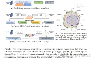
Written in front & starting point The end-to-end paradigm uses a unified framework to achieve multi-tasking in autonomous driving systems. Despite the simplicity and clarity of this paradigm, the performance of end-to-end autonomous driving methods on subtasks still lags far behind single-task methods. At the same time, the dense bird's-eye view (BEV) features widely used in previous end-to-end methods make it difficult to scale to more modalities or tasks. A sparse search-centric end-to-end autonomous driving paradigm (SparseAD) is proposed here, in which sparse search fully represents the entire driving scenario, including space, time, and tasks, without any dense BEV representation. Specifically, a unified sparse architecture is designed for task awareness including detection, tracking, and online mapping. In addition, heavy
 SIMPL: A simple and efficient multi-agent motion prediction benchmark for autonomous driving
Feb 20, 2024 am 11:48 AM
SIMPL: A simple and efficient multi-agent motion prediction benchmark for autonomous driving
Feb 20, 2024 am 11:48 AM
Original title: SIMPL: ASimpleandEfficientMulti-agentMotionPredictionBaselineforAutonomousDriving Paper link: https://arxiv.org/pdf/2402.02519.pdf Code link: https://github.com/HKUST-Aerial-Robotics/SIMPL Author unit: Hong Kong University of Science and Technology DJI Paper idea: This paper proposes a simple and efficient motion prediction baseline (SIMPL) for autonomous vehicles. Compared with traditional agent-cent
 Let's talk about end-to-end and next-generation autonomous driving systems, as well as some misunderstandings about end-to-end autonomous driving?
Apr 15, 2024 pm 04:13 PM
Let's talk about end-to-end and next-generation autonomous driving systems, as well as some misunderstandings about end-to-end autonomous driving?
Apr 15, 2024 pm 04:13 PM
In the past month, due to some well-known reasons, I have had very intensive exchanges with various teachers and classmates in the industry. An inevitable topic in the exchange is naturally end-to-end and the popular Tesla FSDV12. I would like to take this opportunity to sort out some of my thoughts and opinions at this moment for your reference and discussion. How to define an end-to-end autonomous driving system, and what problems should be expected to be solved end-to-end? According to the most traditional definition, an end-to-end system refers to a system that inputs raw information from sensors and directly outputs variables of concern to the task. For example, in image recognition, CNN can be called end-to-end compared to the traditional feature extractor + classifier method. In autonomous driving tasks, input data from various sensors (camera/LiDAR
 FisheyeDetNet: the first target detection algorithm based on fisheye camera
Apr 26, 2024 am 11:37 AM
FisheyeDetNet: the first target detection algorithm based on fisheye camera
Apr 26, 2024 am 11:37 AM
Target detection is a relatively mature problem in autonomous driving systems, among which pedestrian detection is one of the earliest algorithms to be deployed. Very comprehensive research has been carried out in most papers. However, distance perception using fisheye cameras for surround view is relatively less studied. Due to large radial distortion, standard bounding box representation is difficult to implement in fisheye cameras. To alleviate the above description, we explore extended bounding box, ellipse, and general polygon designs into polar/angular representations and define an instance segmentation mIOU metric to analyze these representations. The proposed model fisheyeDetNet with polygonal shape outperforms other models and simultaneously achieves 49.5% mAP on the Valeo fisheye camera dataset for autonomous driving
 DualBEV: significantly surpassing BEVFormer and BEVDet4D, open the book!
Mar 21, 2024 pm 05:21 PM
DualBEV: significantly surpassing BEVFormer and BEVDet4D, open the book!
Mar 21, 2024 pm 05:21 PM
This paper explores the problem of accurately detecting objects from different viewing angles (such as perspective and bird's-eye view) in autonomous driving, especially how to effectively transform features from perspective (PV) to bird's-eye view (BEV) space. Transformation is implemented via the Visual Transformation (VT) module. Existing methods are broadly divided into two strategies: 2D to 3D and 3D to 2D conversion. 2D-to-3D methods improve dense 2D features by predicting depth probabilities, but the inherent uncertainty of depth predictions, especially in distant regions, may introduce inaccuracies. While 3D to 2D methods usually use 3D queries to sample 2D features and learn the attention weights of the correspondence between 3D and 2D features through a Transformer, which increases the computational and deployment time.
