
 Technology peripherals
AI
Artificial Intelligence-driven geospatial analytics could change the world
Technology peripherals
AI
Artificial Intelligence-driven geospatial analytics could change the world
Artificial Intelligence-driven geospatial analytics could change the world

Today artificial intelligence is shaping a better way. Although AI is still relatively new to the geospatial industry, it allows professionals in various fields to work more efficiently and accurately, respond to issues faster, and save money. Property insurance companies can better pinpoint risks. Banks can speed up disbursement of loans to farmers. Utilities can better understand where to and where not to lay transmission lines and more.

Artificial intelligence processes multiple layers of complex data and images to provide insights more accurately and faster than humans.
Prospects and Problems of Geospatial Technology
Commercial companies want to gain insights from geospatial data, but they want an easier way to find them. Deloitte reports that by next year, 36% of large and medium-sized organizations are expected to deploy location intelligence software, up from 10% in 2019.
Geospatial data is a bunch of information: GIS maps, lidar images, survey records. Remote sensing data obtained from satellites require processing to be useful to most researchers and other users. A single data source is often insufficient, so modeling often requires piecing together disjointed data sources.
Geospatial analysis requires multiple steps and specialized skills. Data needs to be collected from various sources and converted into multi-layered visual representations and mappings. Sources include Earth observation, geographic information systems (GIS), global satellite navigation systems and drone 3D scanning.
Needs to analyze the mapping to determine the pattern. This process may require remote sensing and image processing tools, mapping skills and other specialized talents, as well as specific programming languages.
Meticulous Research reports that the use of AI-based GIS solutions across different industries is rapidly advancing the data collection and cleaning process to improve forecast accuracy. The geospatial analytics market is expected to grow at a CAGR of 17.6% from 2021 to 2028, reaching $256 billion.
AI unlocks the potential of geospatial data
Deloitte points to areas of application: businesses optimizing their supply chain networks; governments improving land management practices; power companies managing vegetation along power grids risk.
Technology solutions are leveraging artificial intelligence to act faster, save money and stay safe. AI can handle menial tasks, analyze large amounts of data points, improve accuracy, and deliver timely takeaways.
Through automation, artificial intelligence can extract information and provide insights in real time. AI algorithms can predict wildfire risk, identify wetlands, classify vegetation types to evaluate reclamation activities and provide countless applications.
For example, energy companies can use this technology to understand the environmental risks faced by their pipelines, such as landslides and floods, and how best to prioritize monitoring efforts. Better manage the environment, save money, and help ensure public safety.
Conventional climate models may be too broad and outdated. Trends in increased precipitation over the years may be less important than understanding where soil erosion poses landslide risks to infrastructure. Without the need for on-the-ground assessments, teams using artificial intelligence to analyze lidar image information can assess impacts without putting people in harm’s way.
What will happen in the future
As geospatial technology and imaging technology continue to improve, the possibilities for the future can be imagined. Just look at your phone to see how much progress has been made in just a few years. What's your best camera? Your smartphone. What's the best sat nav system for you? Your smartphone.
It’s no coincidence that artificial intelligence is now helping analyze satellite images to better understand climate change. "Our goal is to pioneer a new combination of deep learning algorithms and decades of physics knowledge to create synthetic high-resolution satellite images of Antarctic surface melt," said Guido Cervone, associate director of Penn State's Institute for Computational and Data Sciences.
AI-led approaches to geospatial analysis will revolutionize the way many professionals work – more efficiently, accurately, timely and securely, and more insightfully. At the same time, it will change their industry and the world.
The above is the detailed content of Artificial Intelligence-driven geospatial analytics could change the world. For more information, please follow other related articles on the PHP Chinese website!

Hot AI Tools

Undresser.AI Undress
AI-powered app for creating realistic nude photos

AI Clothes Remover
Online AI tool for removing clothes from photos.

Undress AI Tool
Undress images for free

Clothoff.io
AI clothes remover

AI Hentai Generator
Generate AI Hentai for free.
Hot Article
Hot Tools

Notepad++7.3.1
Easy-to-use and free code editor

SublimeText3 Chinese version
Chinese version, very easy to use

Zend Studio 13.0.1
Powerful PHP integrated development environment

Dreamweaver CS6
Visual web development tools

SublimeText3 Mac version
God-level code editing software (SublimeText3)
Hot Topics
 1376
1376
 52
52

 Bytedance Cutting launches SVIP super membership: 499 yuan for continuous annual subscription, providing a variety of AI functions
Jun 28, 2024 am 03:51 AM
Bytedance Cutting launches SVIP super membership: 499 yuan for continuous annual subscription, providing a variety of AI functions
Jun 28, 2024 am 03:51 AM
This site reported on June 27 that Jianying is a video editing software developed by FaceMeng Technology, a subsidiary of ByteDance. It relies on the Douyin platform and basically produces short video content for users of the platform. It is compatible with iOS, Android, and Windows. , MacOS and other operating systems. Jianying officially announced the upgrade of its membership system and launched a new SVIP, which includes a variety of AI black technologies, such as intelligent translation, intelligent highlighting, intelligent packaging, digital human synthesis, etc. In terms of price, the monthly fee for clipping SVIP is 79 yuan, the annual fee is 599 yuan (note on this site: equivalent to 49.9 yuan per month), the continuous monthly subscription is 59 yuan per month, and the continuous annual subscription is 499 yuan per year (equivalent to 41.6 yuan per month) . In addition, the cut official also stated that in order to improve the user experience, those who have subscribed to the original VIP
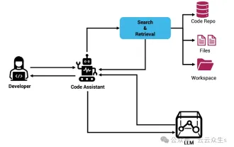 Context-augmented AI coding assistant using Rag and Sem-Rag
Jun 10, 2024 am 11:08 AM
Context-augmented AI coding assistant using Rag and Sem-Rag
Jun 10, 2024 am 11:08 AM
Improve developer productivity, efficiency, and accuracy by incorporating retrieval-enhanced generation and semantic memory into AI coding assistants. Translated from EnhancingAICodingAssistantswithContextUsingRAGandSEM-RAG, author JanakiramMSV. While basic AI programming assistants are naturally helpful, they often fail to provide the most relevant and correct code suggestions because they rely on a general understanding of the software language and the most common patterns of writing software. The code generated by these coding assistants is suitable for solving the problems they are responsible for solving, but often does not conform to the coding standards, conventions and styles of the individual teams. This often results in suggestions that need to be modified or refined in order for the code to be accepted into the application
 The largest domestically produced unmanned transport aircraft successfully made its maiden flight: equipped with China Aviation Engineering Group's AEP100-A engine
Aug 23, 2024 am 07:32 AM
The largest domestically produced unmanned transport aircraft successfully made its maiden flight: equipped with China Aviation Engineering Group's AEP100-A engine
Aug 23, 2024 am 07:32 AM
According to news from this website on August 22, China Aviation Engine Group Co., Ltd. issued an official announcement today. At 6:28 today, the 900-kilowatt turboprop engine AEP100-A, which was completely independently developed by China Aviation Industry Corporation, powered the SA750U large unmanned transport aircraft in Shaanxi. Successful first flight. According to reports, the AEP100-A turboprop engine was designed by the China Aerospace Engineering Research Institute and manufactured in the South. It has the ability to adapt to high temperatures and plateaus. It uses three-dimensional aerodynamic design and unit design technology to provide power for aircraft while improving fuel economy. Improve overall aircraft operating efficiency. The AEP100 turboprop engine series can be equipped with 2 to 6 ton general-purpose aircraft or 3 to 10 ton unmanned aerial vehicles, and its comprehensive performance has reached the international advanced level of the same level currently in service. This site reported earlier
 Seven Cool GenAI & LLM Technical Interview Questions
Jun 07, 2024 am 10:06 AM
Seven Cool GenAI & LLM Technical Interview Questions
Jun 07, 2024 am 10:06 AM
To learn more about AIGC, please visit: 51CTOAI.x Community https://www.51cto.com/aigc/Translator|Jingyan Reviewer|Chonglou is different from the traditional question bank that can be seen everywhere on the Internet. These questions It requires thinking outside the box. Large Language Models (LLMs) are increasingly important in the fields of data science, generative artificial intelligence (GenAI), and artificial intelligence. These complex algorithms enhance human skills and drive efficiency and innovation in many industries, becoming the key for companies to remain competitive. LLM has a wide range of applications. It can be used in fields such as natural language processing, text generation, speech recognition and recommendation systems. By learning from large amounts of data, LLM is able to generate text
 Can fine-tuning really allow LLM to learn new things: introducing new knowledge may make the model produce more hallucinations
Jun 11, 2024 pm 03:57 PM
Can fine-tuning really allow LLM to learn new things: introducing new knowledge may make the model produce more hallucinations
Jun 11, 2024 pm 03:57 PM
Large Language Models (LLMs) are trained on huge text databases, where they acquire large amounts of real-world knowledge. This knowledge is embedded into their parameters and can then be used when needed. The knowledge of these models is "reified" at the end of training. At the end of pre-training, the model actually stops learning. Align or fine-tune the model to learn how to leverage this knowledge and respond more naturally to user questions. But sometimes model knowledge is not enough, and although the model can access external content through RAG, it is considered beneficial to adapt the model to new domains through fine-tuning. This fine-tuning is performed using input from human annotators or other LLM creations, where the model encounters additional real-world knowledge and integrates it
 To provide a new scientific and complex question answering benchmark and evaluation system for large models, UNSW, Argonne, University of Chicago and other institutions jointly launched the SciQAG framework
Jul 25, 2024 am 06:42 AM
To provide a new scientific and complex question answering benchmark and evaluation system for large models, UNSW, Argonne, University of Chicago and other institutions jointly launched the SciQAG framework
Jul 25, 2024 am 06:42 AM
Editor |ScienceAI Question Answering (QA) data set plays a vital role in promoting natural language processing (NLP) research. High-quality QA data sets can not only be used to fine-tune models, but also effectively evaluate the capabilities of large language models (LLM), especially the ability to understand and reason about scientific knowledge. Although there are currently many scientific QA data sets covering medicine, chemistry, biology and other fields, these data sets still have some shortcomings. First, the data form is relatively simple, most of which are multiple-choice questions. They are easy to evaluate, but limit the model's answer selection range and cannot fully test the model's ability to answer scientific questions. In contrast, open-ended Q&A
 SOTA performance, Xiamen multi-modal protein-ligand affinity prediction AI method, combines molecular surface information for the first time
Jul 17, 2024 pm 06:37 PM
SOTA performance, Xiamen multi-modal protein-ligand affinity prediction AI method, combines molecular surface information for the first time
Jul 17, 2024 pm 06:37 PM
Editor | KX In the field of drug research and development, accurately and effectively predicting the binding affinity of proteins and ligands is crucial for drug screening and optimization. However, current studies do not take into account the important role of molecular surface information in protein-ligand interactions. Based on this, researchers from Xiamen University proposed a novel multi-modal feature extraction (MFE) framework, which for the first time combines information on protein surface, 3D structure and sequence, and uses a cross-attention mechanism to compare different modalities. feature alignment. Experimental results demonstrate that this method achieves state-of-the-art performance in predicting protein-ligand binding affinities. Furthermore, ablation studies demonstrate the effectiveness and necessity of protein surface information and multimodal feature alignment within this framework. Related research begins with "S
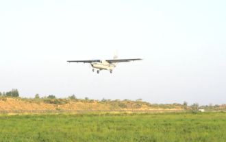 my country's first large-scale unmanned transport aircraft with a load exceeding 3 tons, the 'SA750U', successfully made its maiden flight, with nationally produced systems and materials
Aug 23, 2024 am 07:31 AM
my country's first large-scale unmanned transport aircraft with a load exceeding 3 tons, the 'SA750U', successfully made its maiden flight, with nationally produced systems and materials
Aug 23, 2024 am 07:31 AM
According to news from this site on August 22, according to the official public account of "Shanhe Huayu", at 6:28 today, the SA750U large unmanned transport aircraft independently developed by Sunward Huayu Aviation Technology and completed by the strategic coordination of Sunward Star Airlines flew from Jingbian, Xi'an. The experimental drone test center successfully made its first flight. ▲Picture source "Shanhe Huayu" official public account, the same as below. According to reports, during the 40-minute flight test, all system equipment of the aircraft worked normally and were in good condition. The attitude of the aircraft was stable and the performance met the design specifications. After completing the scheduled flight subjects Afterwards, the plane returned smoothly and the first flight was a complete success. The SA750U is my country's first large-scale unmanned transport aircraft with a load of over 3 tons. It only took Shanhe Huayu Company 2 years and 8 months to complete the entire process from concept design to the successful first flight of the first aircraft.
