

How to use pyecharts to draw geographical charts in Python

Map Template Series
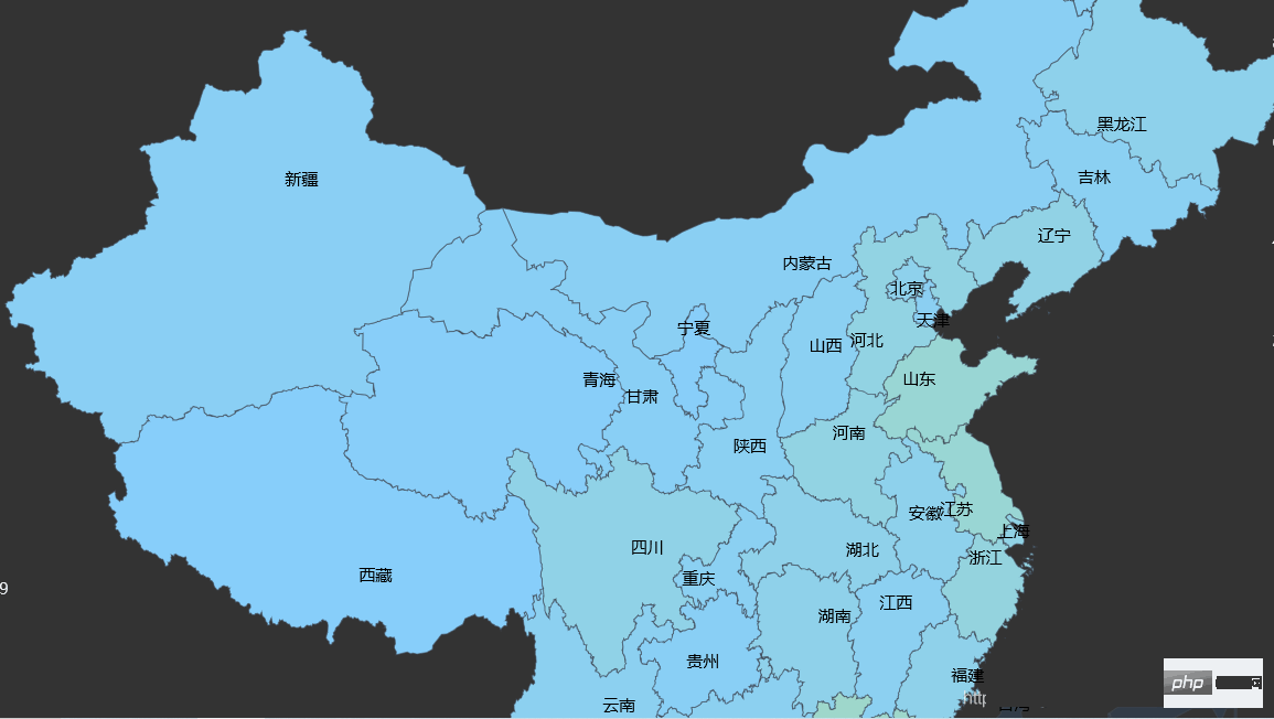
China Map
Shows all the provinces in China, a complete simple geographical figure of China, making it easier for you to understand the distribution of cities!
from pyecharts import options as opts
from pyecharts.charts import Map
from pyecharts.faker import Faker

c = (
Map()
.add("城市", [list(z) for z in zip(Faker.provinces, Faker.values())], "china")
.set_global_opts(title_opts=opts.TitleOpts(title="中国地图"))
.render("中国地图.html")
)
print([list(z) for z in zip(Faker.provinces, Faker.values())])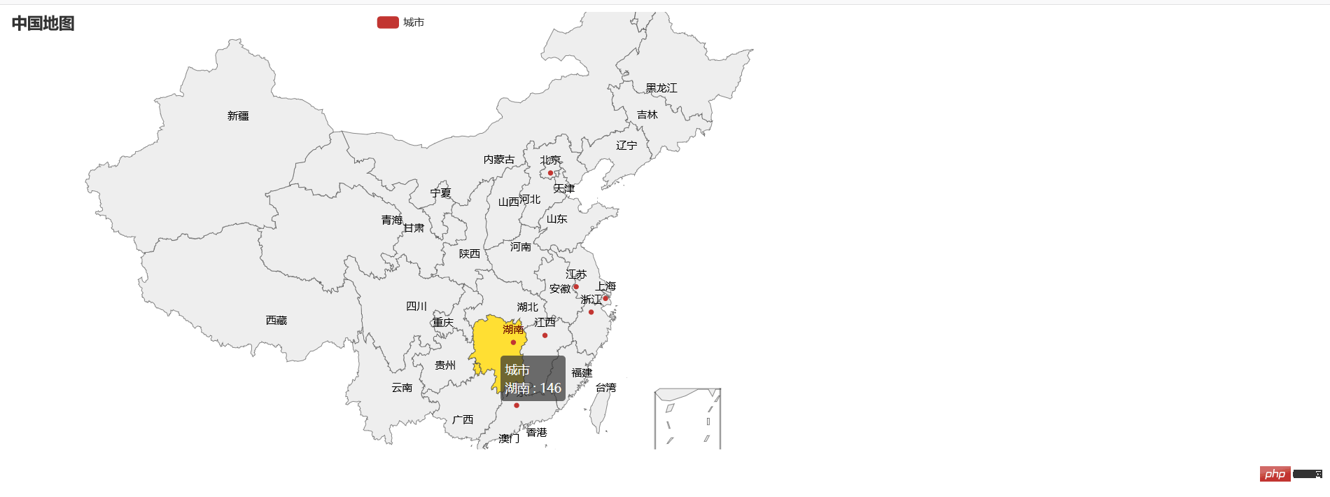
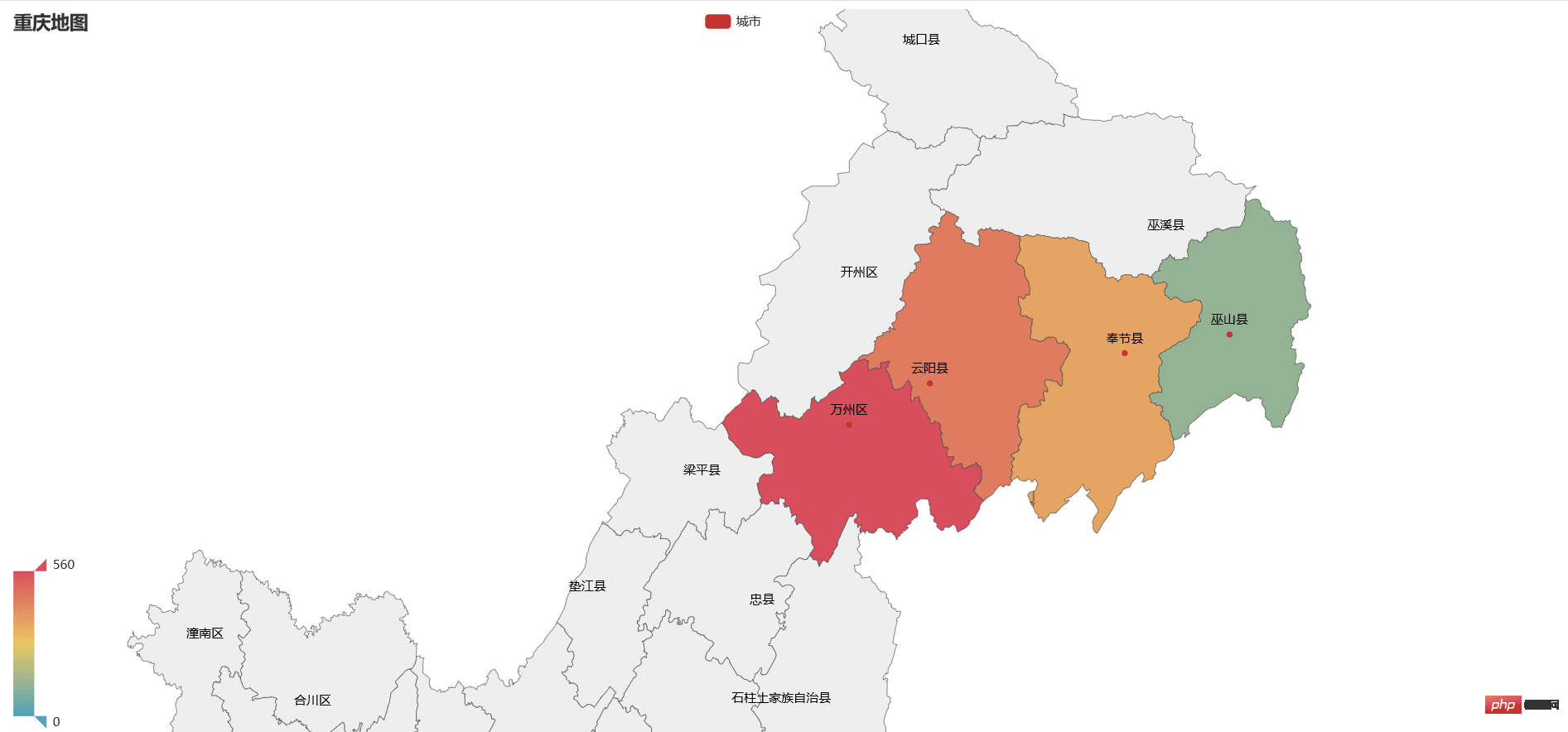
Provincial data map (Chongqing map)
from pyecharts import options as opts
from pyecharts.charts import Map
from pyecharts.faker import Faker
x=["巫山县","万州区","云阳县","奉节县"]
y=[123,560,456,362]
c = (
Map(init_opts=opts.InitOpts(width="1400px", height="700px"))
.add("城市", [list(z) for z in zip(x,y)], "重庆")
.set_global_opts(
title_opts=opts.TitleOpts(title="重庆地图"), visualmap_opts=opts.VisualMapOpts(max_=560)
)
.render("重庆地图.html")
)
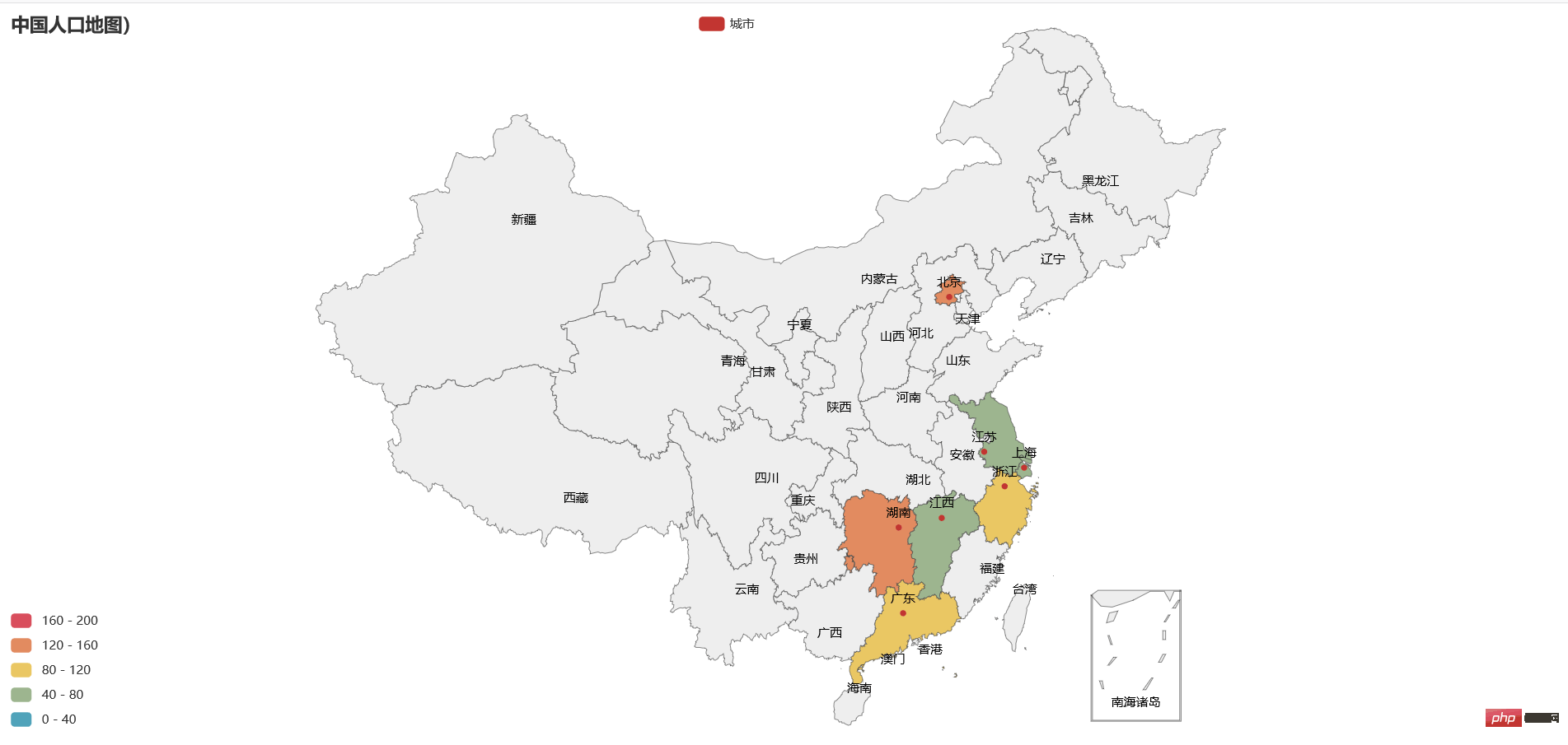
from pyecharts import options as opts
from pyecharts.charts import Map
from pyecharts.faker import Faker

c = (
Map(init_opts=opts.InitOpts(width="1400px", height="700px"))
.add("城市", [list(z) for z in zip(Faker.provinces, Faker.values())], "china")
.set_global_opts(
title_opts=opts.TitleOpts(title="中国人口地图)"),
visualmap_opts=opts.VisualMapOpts(max_=200, is_piecewise=True),
)
.render("中国分段地图.html")
)
{
"Somalia": "索马里",
"Liechtenstein": "列支敦士登",
"Morocco": "摩洛哥",
"W. Sahara": "西撒哈拉",
"Serbia": "塞尔维亚",
"Afghanistan": "阿富汗",
"Angola": "安哥拉",
"Albania": "阿尔巴尼亚",
"Andorra": "安道尔共和国",
"United Arab Emirates": "阿拉伯联合酋长国",
"Argentina": "阿根廷",
"Armenia": "亚美尼亚",
"Australia": "澳大利亚",
"Austria": "奥地利",
"Azerbaijan": "阿塞拜疆",
"Burundi": "布隆迪",
"Belgium": "比利时",
"Benin": "贝宁",
"Burkina Faso": "布基纳法索",
"Bangladesh": "孟加拉国",
"Bulgaria": "保加利亚",
"Bahrain": "巴林",
"Bahamas": "巴哈马",
"Bosnia and Herz.": "波斯尼亚和黑塞哥维那",
"Belarus": "白俄罗斯",
"Belize": "伯利兹",
"Bermuda": "百慕大",
"Bolivia": "玻利维亚",
"Brazil": "巴西",
"Barbados": "巴巴多斯",
"Brunei": "文莱",
"Bhutan": "不丹",
"Botswana": "博茨瓦纳",
"Central African Rep.": "中非",
"Canada": "加拿大",
"Switzerland": "瑞士",
"Chile": "智利",
"China": "中国",
"Côte d'Ivoire": "科特迪瓦",
"Cameroon": "喀麦隆",
"Dem. Rep. Congo": "刚果民主共和国",
"Congo": "刚果",
"Colombia": "哥伦比亚",
"Cape Verde": "佛得角",
"Costa Rica": "哥斯达黎加",
"Cuba": "古巴",
"N. Cyprus": "北塞浦路斯",
"Cyprus": "塞浦路斯",
"Czech Rep.": "捷克",
"Germany": "德国",
"Djibouti": "吉布提",
"Denmark": "丹麦",
"Dominican Rep.": "多米尼加",
"Algeria": "阿尔及利亚",
"Ecuador": "厄瓜多尔",
"Egypt": "埃及",
"Eritrea": "厄立特里亚",
"Spain": "西班牙",
"Estonia": "爱沙尼亚",
"Ethiopia": "埃塞俄比亚",
"Finland": "芬兰",
"Fiji": "斐济",
"France": "法国",
"Gabon": "加蓬",
"United Kingdom": "英国",
"Georgia": "格鲁吉亚",
"Ghana": "加纳",
"Guinea": "几内亚",
"Gambia": "冈比亚",
"Guinea-Bissau": "几内亚比绍",
"Eq. Guinea": "赤道几内亚",
"Greece": "希腊",
"Grenada": "格林纳达",
"Greenland": "格陵兰",
"Guatemala": "危地马拉",
"Guam": "关岛",
"Guyana": "圭亚那",
"Honduras": "洪都拉斯",
"Croatia": "克罗地亚",
"Haiti": "海地",
"Hungary": "匈牙利",
"Indonesia": "印度尼西亚",
"India": "印度",
"Br. Indian Ocean Ter.": "英属印度洋领土",
"Ireland": "爱尔兰",
"Iran": "伊朗",
"Iraq": "伊拉克",
"Iceland": "冰岛",
"Israel": "以色列",
"Italy": "意大利",
"Jamaica": "牙买加",
"Jordan": "约旦",
"Japan": "日本",
"Siachen Glacier": "锡亚琴冰川",
"Kazakhstan": "哈萨克斯坦",
"Kenya": "肯尼亚",
"Kyrgyzstan": "吉尔吉斯坦",
"Cambodia": "柬埔寨",
"Korea": "韩国",
"Kuwait": "科威特",
"Lao PDR": "老挝",
"Lebanon": "黎巴嫩",
"Liberia": "利比里亚",
"Libya": "利比亚",
"Sri Lanka": "斯里兰卡",
"Lesotho": "莱索托",
"Lithuania": "立陶宛",
"Luxembourg": "卢森堡",
"Latvia": "拉脱维亚",
"Moldova": "摩尔多瓦",
"Madagascar": "马达加斯加",
"Mexico": "墨西哥",
"Macedonia": "马其顿",
"Mali": "马里",
"Malta": "马耳他",
"Myanmar": "缅甸",
"Montenegro": "黑山",
"Mongolia": "蒙古",
"Mozambique": "莫桑比克",
"Mauritania": "毛里塔尼亚",
"Mauritius": "毛里求斯",
"Malawi": "马拉维",
"Malaysia": "马来西亚",
"Namibia": "纳米比亚",
"New Caledonia": "新喀里多尼亚",
"Niger": "尼日尔",
"Nigeria": "尼日利亚",
"Nicaragua": "尼加拉瓜",
"Netherlands": "荷兰",
"Norway": "挪威",
"Nepal": "尼泊尔",
"New Zealand": "新西兰",
"Oman": "阿曼",
"Pakistan": "巴基斯坦",
"Panama": "巴拿马",
"Peru": "秘鲁",
"Philippines": "菲律宾",
"Papua New Guinea": "巴布亚新几内亚",
"Poland": "波兰",
"Puerto Rico": "波多黎各",
"Dem. Rep. Korea": "朝鲜",
"Portugal": "葡萄牙",
"Paraguay": "巴拉圭",
"Palestine": "巴勒斯坦",
"Qatar": "卡塔尔",
"Romania": "罗马尼亚",
"Russia": "俄罗斯",
"Rwanda": "卢旺达",
"Saudi Arabia": "沙特阿拉伯",
"Sudan": "苏丹",
"S. Sudan": "南苏丹",
"Senegal": "塞内加尔",
"Singapore": "新加坡",
"Solomon Is.": "所罗门群岛",
"Sierra Leone": "塞拉利昂",
"El Salvador": "萨尔瓦多",
"Suriname": "苏里南",
"Slovakia": "斯洛伐克",
"Slovenia": "斯洛文尼亚",
"Sweden": "瑞典",
"Swaziland": "斯威士兰",
"Seychelles": "塞舌尔",
"Syria": "叙利亚",
"Chad": "乍得",
"Togo": "多哥",
"Thailand": "泰国",
"Tajikistan": "塔吉克斯坦",
"Turkmenistan": "土库曼斯坦",
"Timor-Leste": "东帝汶",
"Tonga": "汤加",
"Trinidad and Tobago": "特立尼达和多巴哥",
"Tunisia": "突尼斯",
"Turkey": "土耳其",
"Tanzania": "坦桑尼亚",
"Uganda": "乌干达",
"Ukraine": "乌克兰",
"Uruguay": "乌拉圭",
"United States": "美国",
"Uzbekistan": "乌兹别克斯坦",
"Venezuela": "委内瑞拉",
"Vietnam": "越南",
"Vanuatu": "瓦努阿图",
"Yemen": "也门",
"South Africa": "南非",
"Zambia": "赞比亚",
"Zimbabwe": "津巴布韦",
"Aland": "奥兰群岛",
"American Samoa": "美属萨摩亚",
"Fr. S. Antarctic Lands": "南极洲",
"Antigua and Barb.": "安提瓜和巴布达",
"Comoros": "科摩罗",
"Curaçao": "库拉索岛",
"Cayman Is.": "开曼群岛",
"Dominica": "多米尼加",
"Falkland Is.": "马尔维纳斯群岛(福克兰)",
"Faeroe Is.": "法罗群岛",
"Micronesia": "密克罗尼西亚",
"Heard I. and McDonald Is.": "赫德岛和麦克唐纳群岛",
"Isle of Man": "曼岛",
"Jersey": "泽西岛",
"Kiribati": "基里巴斯",
"Saint Lucia": "圣卢西亚",
"N. Mariana Is.": "北马里亚纳群岛",
"Montserrat": "蒙特塞拉特",
"Niue": "纽埃",
"Palau": "帕劳",
"Fr. Polynesia": "法属波利尼西亚",
"S. Geo. and S. Sandw. Is.": "南乔治亚岛和南桑威奇群岛",
"Saint Helena": "圣赫勒拿",
"St. Pierre and Miquelon": "圣皮埃尔和密克隆群岛",
"São Tomé and Principe": "圣多美和普林西比",
"Turks and Caicos Is.": "特克斯和凯科斯群岛",
"St. Vin. and Gren.": "圣文森特和格林纳丁斯",
"U.S. Virgin Is.": "美属维尔京群岛",
"Samoa": "萨摩亚"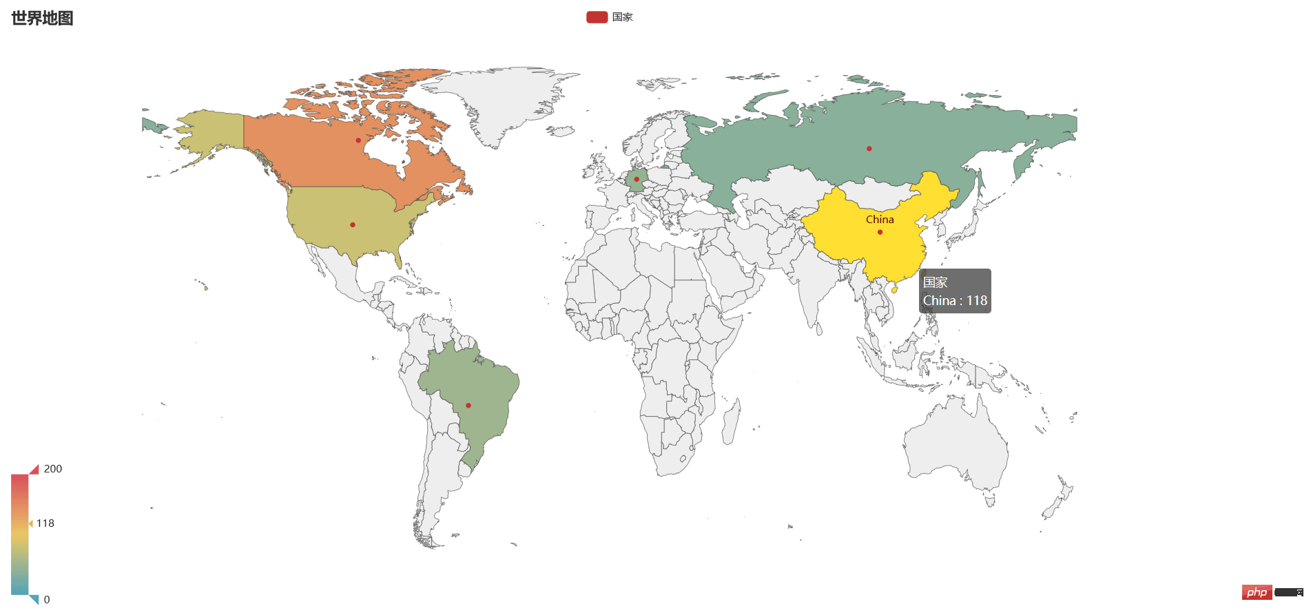
}from pyecharts import options as opts
from pyecharts.charts import Map
from pyecharts.faker import Faker
c = (
Map(init_opts=opts.InitOpts(width="1400px", height="700px"))
.add("国家", [list(z) for z in zip(Faker.country, Faker.values())], "world")
.set_series_opts(label_opts=opts.LabelOpts(is_show=False))
.set_global_opts(
title_opts=opts.TitleOpts(title="世界地图"),
visualmap_opts=opts.VisualMapOpts(max_=200),
)
.render("世界地图.html")
)
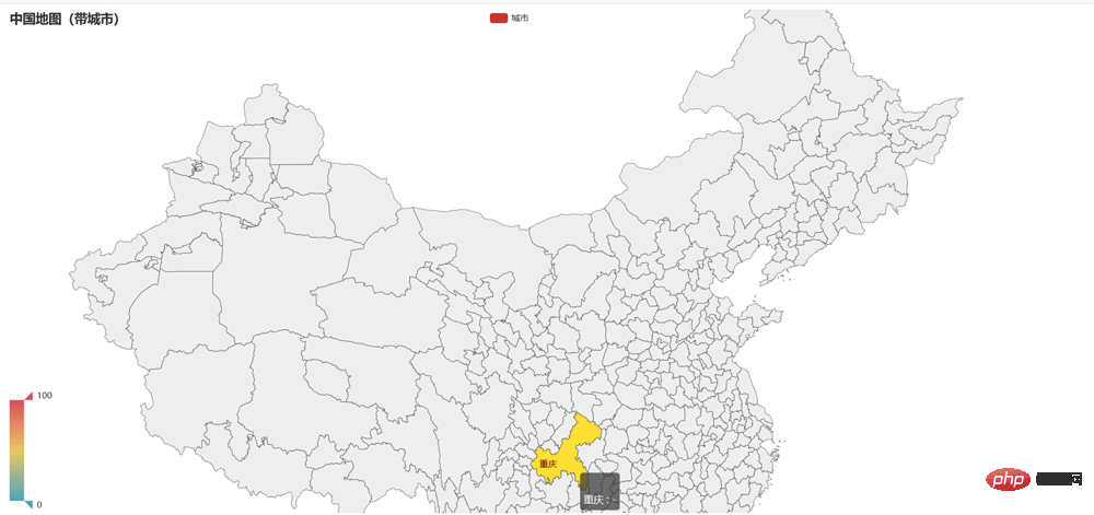
from pyecharts import options as opts
from pyecharts.charts import Map
from pyecharts.faker import Faker

c = (
Map(init_opts=opts.InitOpts(width="1400px", height="700px"))
.add(
"城市",
[list(z) for z in zip(Faker.guangdong_city, Faker.values())],
"china-cities",
label_opts=opts.LabelOpts(is_show=False),
)
.set_global_opts(
title_opts=opts.TitleOpts(title="中国地图(带城市)"),
visualmap_opts=opts.VisualMapOpts(),
)
.render("中国地图带城市.html")
)
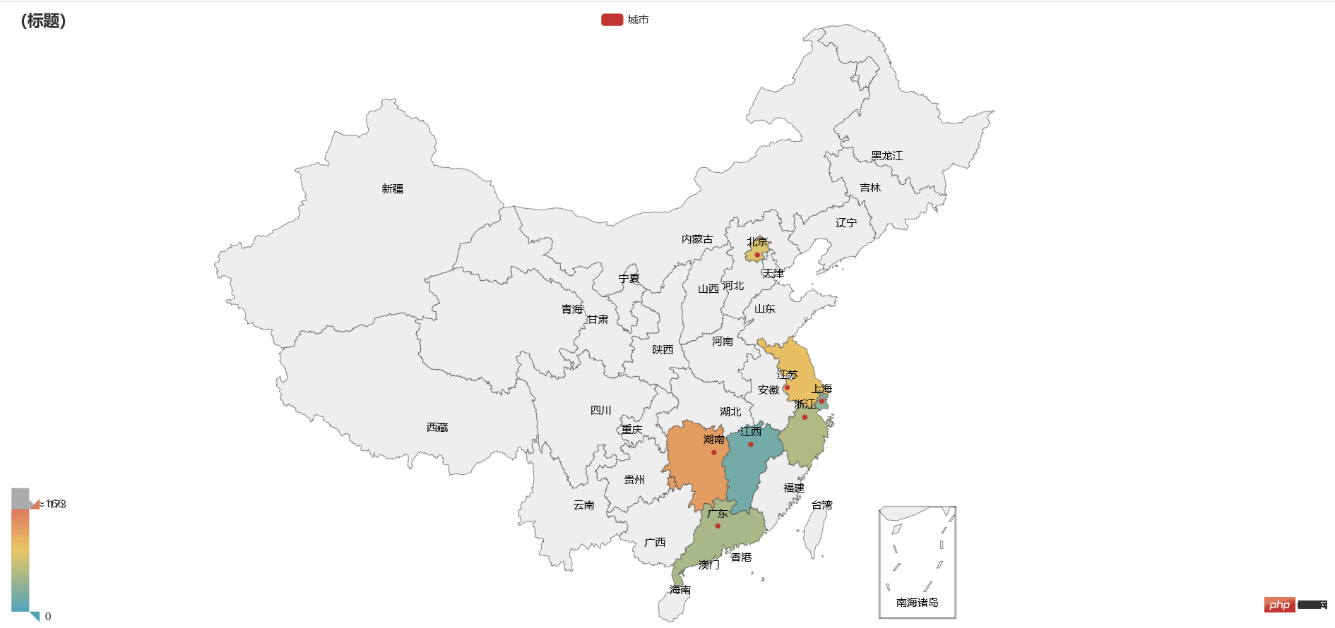
from pyecharts import options as opts
from pyecharts.charts import Map
from pyecharts.faker import Faker

c = (
Map(init_opts=opts.InitOpts(width="1400px", height="700px"))
.add("城市", [list(z) for z in zip(Faker.provinces, Faker.values())], "china")
.set_global_opts(
title_opts=opts.TitleOpts(title="(标题)"),
visualmap_opts=opts.VisualMapOpts(max_=200),
)
.render("连续数据地图.html")
)

The above is the detailed content of How to use pyecharts to draw geographical charts in Python. For more information, please follow other related articles on the PHP Chinese website!

Hot AI Tools

Undresser.AI Undress
AI-powered app for creating realistic nude photos

AI Clothes Remover
Online AI tool for removing clothes from photos.

Undress AI Tool
Undress images for free

Clothoff.io
AI clothes remover

Video Face Swap
Swap faces in any video effortlessly with our completely free AI face swap tool!

Hot Article
Hot Tools

Notepad++7.3.1
Easy-to-use and free code editor

SublimeText3 Chinese version
Chinese version, very easy to use

Zend Studio 13.0.1
Powerful PHP integrated development environment

Dreamweaver CS6
Visual web development tools

SublimeText3 Mac version
God-level code editing software (SublimeText3)
Hot Topics
 1389
1389
 52
52

 Choosing Between PHP and Python: A Guide
Apr 18, 2025 am 12:24 AM
Choosing Between PHP and Python: A Guide
Apr 18, 2025 am 12:24 AM
PHP is suitable for web development and rapid prototyping, and Python is suitable for data science and machine learning. 1.PHP is used for dynamic web development, with simple syntax and suitable for rapid development. 2. Python has concise syntax, is suitable for multiple fields, and has a strong library ecosystem.
 PHP and Python: Different Paradigms Explained
Apr 18, 2025 am 12:26 AM
PHP and Python: Different Paradigms Explained
Apr 18, 2025 am 12:26 AM
PHP is mainly procedural programming, but also supports object-oriented programming (OOP); Python supports a variety of paradigms, including OOP, functional and procedural programming. PHP is suitable for web development, and Python is suitable for a variety of applications such as data analysis and machine learning.
 Can vs code run in Windows 8
Apr 15, 2025 pm 07:24 PM
Can vs code run in Windows 8
Apr 15, 2025 pm 07:24 PM
VS Code can run on Windows 8, but the experience may not be great. First make sure the system has been updated to the latest patch, then download the VS Code installation package that matches the system architecture and install it as prompted. After installation, be aware that some extensions may be incompatible with Windows 8 and need to look for alternative extensions or use newer Windows systems in a virtual machine. Install the necessary extensions to check whether they work properly. Although VS Code is feasible on Windows 8, it is recommended to upgrade to a newer Windows system for a better development experience and security.
 Is the vscode extension malicious?
Apr 15, 2025 pm 07:57 PM
Is the vscode extension malicious?
Apr 15, 2025 pm 07:57 PM
VS Code extensions pose malicious risks, such as hiding malicious code, exploiting vulnerabilities, and masturbating as legitimate extensions. Methods to identify malicious extensions include: checking publishers, reading comments, checking code, and installing with caution. Security measures also include: security awareness, good habits, regular updates and antivirus software.
 How to run programs in terminal vscode
Apr 15, 2025 pm 06:42 PM
How to run programs in terminal vscode
Apr 15, 2025 pm 06:42 PM
In VS Code, you can run the program in the terminal through the following steps: Prepare the code and open the integrated terminal to ensure that the code directory is consistent with the terminal working directory. Select the run command according to the programming language (such as Python's python your_file_name.py) to check whether it runs successfully and resolve errors. Use the debugger to improve debugging efficiency.
 Can visual studio code be used in python
Apr 15, 2025 pm 08:18 PM
Can visual studio code be used in python
Apr 15, 2025 pm 08:18 PM
VS Code can be used to write Python and provides many features that make it an ideal tool for developing Python applications. It allows users to: install Python extensions to get functions such as code completion, syntax highlighting, and debugging. Use the debugger to track code step by step, find and fix errors. Integrate Git for version control. Use code formatting tools to maintain code consistency. Use the Linting tool to spot potential problems ahead of time.
 Can vscode be used for mac
Apr 15, 2025 pm 07:36 PM
Can vscode be used for mac
Apr 15, 2025 pm 07:36 PM
VS Code is available on Mac. It has powerful extensions, Git integration, terminal and debugger, and also offers a wealth of setup options. However, for particularly large projects or highly professional development, VS Code may have performance or functional limitations.
 Can vscode run ipynb
Apr 15, 2025 pm 07:30 PM
Can vscode run ipynb
Apr 15, 2025 pm 07:30 PM
The key to running Jupyter Notebook in VS Code is to ensure that the Python environment is properly configured, understand that the code execution order is consistent with the cell order, and be aware of large files or external libraries that may affect performance. The code completion and debugging functions provided by VS Code can greatly improve coding efficiency and reduce errors.
