
 Technology peripherals
AI
Remote sensing comes into life! A drone capable of taking three-dimensional maps was unveiled at the Zhongguancun Forum
Technology peripherals
AI
Remote sensing comes into life! A drone capable of taking three-dimensional maps was unveiled at the Zhongguancun Forum
Remote sensing comes into life! A drone capable of taking three-dimensional maps was unveiled at the Zhongguancun Forum

Beijing Daily Client | Reporter Li Bo
There are satellites in the sky, drones in the sky, and monitoring stations and weather stations on the ground... At the Zhongguancun Forum Exhibition (Science and Technology Expo) that opened today, "Aerospace Grand Picture" revealed the secrets behind remote sensing to the audience.
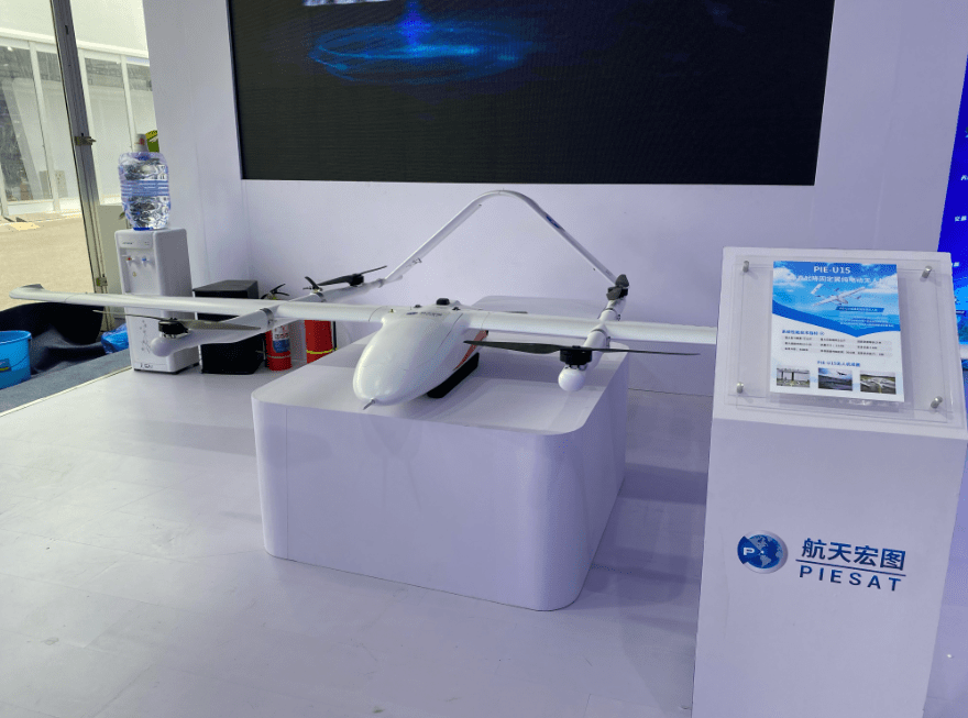
In front of the booth of Aerospace Hongtu Information Technology Co., Ltd., a drone model PIE-U15 Pro extended its wings, arousing the curiosity of many viewers. Unlike aerial photography drones that are generally used to take photos and videos, this drone is a vertical take-off and landing fixed-wing drone that can be equipped with visible light cameras, infrared cameras, tilt cameras, lidar and other equipment, and can quickly acquire and process 3D Data required for modeling. By flying drones, three-dimensional maps can be drawn in real time, and each building, tree and other objects can be presented on the map in a true three-dimensional form. "Compared with three-dimensional maps completed through three-dimensional simulation modeling, surveying and mapping through data collection by drones can restore the original appearance of the real world one-to-one and bring everything in the real world into the digital world." The person in charge of the aerospace grand plan According to the introduction, compared with using satellites, drones can collect data with higher precision and lower cost. They can complete the flight of 400 square kilometers of the city in 10 days and complete the construction of an oblique three-dimensional model of 1,000 centimeter-level resolution images.
With the establishment of the air, space and ground integrated sensing network, more and more remote sensing data are serving natural resources, ecological environment, emergency management, meteorology, agriculture and other industry sectors, as well as finance and insurance, precision agriculture, energy and power, Transportation and other enterprises, and applied to weather monitoring, black and smelly water monitoring, geological disaster prevention and control, marine environment monitoring and other fields.
Currently, the aerospace ambition is planning and building the "Nuwa Constellation" project.
The "Nuwa Constellation" plans to launch more than 110 operational satellites, including 54 in the first phase. After the completion of the "Nuwa Constellation", it will be able to achieve minute-level earth observation, complete coverage of the entire country's land to reach the sky level, complete global coverage to the week level, and satellite remote sensing data acquisition capabilities will reach the international leading level. The first phase of the "Nuwa Constellation" project has 54 operational satellites, including a radar remote sensing constellation composed of 44 radar satellites and an optical remote sensing constellation composed of 10 panchromatic 0.5-meter, multi-spectral 2-meter optical satellites, of which the first 4 The radar remote sensing satellite (Space Hongtu No. 1 satellite) was launched on March 30, 2023. It has global high-resolution wide-band imaging, high-precision surveying and deformation monitoring capabilities, and can quickly and efficiently produce high-precision digital surface models. And complete the global non-polar area surveying and mapping tasks.
After the "Nuwa Constellation" is completed, it will integrate the two networks of the constellation and ground applications, integrate the three functions of communication, navigation, and remote sensing, form a "tongdaoyao" space-space-ground integrated satellite Internet, and build real-time intelligence of air and space information The service platform enhances the ubiquitous perception and intelligent service capabilities of spatio-temporal information in all walks of life, and realizes the integration of multi-source data in communications, navigation, and remote sensing. It will play a great role in urban geological disaster monitoring, ocean monitoring, flood disaster monitoring, surface subsidence monitoring, etc. The advantages can significantly fill the gap in the domestic interferometric synthetic aperture radar (InSAR) satellite application market and help my country's commercial aerospace development reach new heights.
The above is the detailed content of Remote sensing comes into life! A drone capable of taking three-dimensional maps was unveiled at the Zhongguancun Forum. For more information, please follow other related articles on the PHP Chinese website!

Hot AI Tools

Undresser.AI Undress
AI-powered app for creating realistic nude photos

AI Clothes Remover
Online AI tool for removing clothes from photos.

Undress AI Tool
Undress images for free

Clothoff.io
AI clothes remover

AI Hentai Generator
Generate AI Hentai for free.

Hot Article
Hot Tools

Notepad++7.3.1
Easy-to-use and free code editor

SublimeText3 Chinese version
Chinese version, very easy to use

Zend Studio 13.0.1
Powerful PHP integrated development environment

Dreamweaver CS6
Visual web development tools

SublimeText3 Mac version
God-level code editing software (SublimeText3)
Hot Topics
 1385
1385
 52
52

 I Tried Vibe Coding with Cursor AI and It's Amazing!
Mar 20, 2025 pm 03:34 PM
I Tried Vibe Coding with Cursor AI and It's Amazing!
Mar 20, 2025 pm 03:34 PM
Vibe coding is reshaping the world of software development by letting us create applications using natural language instead of endless lines of code. Inspired by visionaries like Andrej Karpathy, this innovative approach lets dev
 Top 5 GenAI Launches of February 2025: GPT-4.5, Grok-3 & More!
Mar 22, 2025 am 10:58 AM
Top 5 GenAI Launches of February 2025: GPT-4.5, Grok-3 & More!
Mar 22, 2025 am 10:58 AM
February 2025 has been yet another game-changing month for generative AI, bringing us some of the most anticipated model upgrades and groundbreaking new features. From xAI’s Grok 3 and Anthropic’s Claude 3.7 Sonnet, to OpenAI’s G
 How to Use YOLO v12 for Object Detection?
Mar 22, 2025 am 11:07 AM
How to Use YOLO v12 for Object Detection?
Mar 22, 2025 am 11:07 AM
YOLO (You Only Look Once) has been a leading real-time object detection framework, with each iteration improving upon the previous versions. The latest version YOLO v12 introduces advancements that significantly enhance accuracy
 Best AI Art Generators (Free & Paid) for Creative Projects
Apr 02, 2025 pm 06:10 PM
Best AI Art Generators (Free & Paid) for Creative Projects
Apr 02, 2025 pm 06:10 PM
The article reviews top AI art generators, discussing their features, suitability for creative projects, and value. It highlights Midjourney as the best value for professionals and recommends DALL-E 2 for high-quality, customizable art.
 Is ChatGPT 4 O available?
Mar 28, 2025 pm 05:29 PM
Is ChatGPT 4 O available?
Mar 28, 2025 pm 05:29 PM
ChatGPT 4 is currently available and widely used, demonstrating significant improvements in understanding context and generating coherent responses compared to its predecessors like ChatGPT 3.5. Future developments may include more personalized interactions and real-time data processing capabilities, further enhancing its potential for various applications.
 Best AI Chatbots Compared (ChatGPT, Gemini, Claude & More)
Apr 02, 2025 pm 06:09 PM
Best AI Chatbots Compared (ChatGPT, Gemini, Claude & More)
Apr 02, 2025 pm 06:09 PM
The article compares top AI chatbots like ChatGPT, Gemini, and Claude, focusing on their unique features, customization options, and performance in natural language processing and reliability.
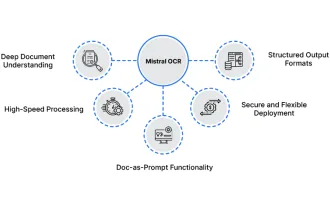 How to Use Mistral OCR for Your Next RAG Model
Mar 21, 2025 am 11:11 AM
How to Use Mistral OCR for Your Next RAG Model
Mar 21, 2025 am 11:11 AM
Mistral OCR: Revolutionizing Retrieval-Augmented Generation with Multimodal Document Understanding Retrieval-Augmented Generation (RAG) systems have significantly advanced AI capabilities, enabling access to vast data stores for more informed respons
 Top AI Writing Assistants to Boost Your Content Creation
Apr 02, 2025 pm 06:11 PM
Top AI Writing Assistants to Boost Your Content Creation
Apr 02, 2025 pm 06:11 PM
The article discusses top AI writing assistants like Grammarly, Jasper, Copy.ai, Writesonic, and Rytr, focusing on their unique features for content creation. It argues that Jasper excels in SEO optimization, while AI tools help maintain tone consist
