
 Technology peripherals
AI
Yongkang, Zhejiang: Drones patrol rivers and protect forests, and aerial imaging panoramic display shows Yangxi Reservoir
Technology peripherals
AI
Yongkang, Zhejiang: Drones patrol rivers and protect forests, and aerial imaging panoramic display shows Yangxi Reservoir
Yongkang, Zhejiang: Drones patrol rivers and protect forests, and aerial imaging panoramic display shows Yangxi Reservoir

China News Service, Zhejiang News, September 19 (Zhang Yicong and Wu Qiaoqiao) Recently, a drone was rising and falling at the Yangxi Reservoir in Yongkang City, Jinhua, Zhejiang. The high-altitude inspection pictures not only showed the conditions of the waters along the line, but also There is also the current status of forest conservation in water source areas. Through drones, Yangxi Reservoir has achieved aerial coverage of river patrols and forest protection, effectively monitored the water environment, and woven a dense forest fire prevention network.
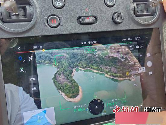
UAV high-altitude imaging picture. Photo courtesy of Yangxi Reservoir Management Center
According to reports, it is reported that Yangxi Reservoir is a first-class drinking water source protection zone. The reservoir has a water collection area of 124 square kilometers and a total storage capacity of 64.53 million cubic meters. Therefore, on the one hand, the quality of water is closely related to the safety of drinking water for people across the region; on the other hand, the forest and soil and water conservation in water source areas are also major issues closely related to people's livelihood
Since this year, the Yangxi Reservoir Management Center has introduced and purchased drones and widely used them in daily river patrol and forest protection work. For example, during an aerial inspection, if illegal activities such as fishing and swimming are discovered within the reservoir area, low-altitude remote sensing technology, edge AI recognition technology, and drone remote calling technology can be used to realize a closed loop of the entire river patrol process
In order to cope with the complex road environment in the forest area of the water source area, the Yangxi Reservoir Management Center took advantage of the high-altitude perspective and real-time image transmission of drones to successfully implement aerial monitoring of forest fires, and further added infrared Thermal imaging lenses, lighting equipment and other equipment can meet the needs of forest protection under different circumstances and provide strong scientific and technological support for the protection of forest resources
In the next step, the Yangxi Reservoir Management Center will arrange for relevant personnel to participate in practical training on drones, giving full play to the advantages of drones, making inspection work regular and long-term, while realizing technology to improve the efficiency of forest firefighting. , continue to strengthen the protection of drinking water sources. (over)
The above is the detailed content of Yongkang, Zhejiang: Drones patrol rivers and protect forests, and aerial imaging panoramic display shows Yangxi Reservoir. For more information, please follow other related articles on the PHP Chinese website!

Hot AI Tools

Undresser.AI Undress
AI-powered app for creating realistic nude photos

AI Clothes Remover
Online AI tool for removing clothes from photos.

Undress AI Tool
Undress images for free

Clothoff.io
AI clothes remover

Video Face Swap
Swap faces in any video effortlessly with our completely free AI face swap tool!

Hot Article
Hot Tools

Notepad++7.3.1
Easy-to-use and free code editor

SublimeText3 Chinese version
Chinese version, very easy to use

Zend Studio 13.0.1
Powerful PHP integrated development environment

Dreamweaver CS6
Visual web development tools

SublimeText3 Mac version
God-level code editing software (SublimeText3)
Hot Topics
 1387
1387
 52
52

 Top 5 GenAI Launches of February 2025: GPT-4.5, Grok-3 & More!
Mar 22, 2025 am 10:58 AM
Top 5 GenAI Launches of February 2025: GPT-4.5, Grok-3 & More!
Mar 22, 2025 am 10:58 AM
February 2025 has been yet another game-changing month for generative AI, bringing us some of the most anticipated model upgrades and groundbreaking new features. From xAI’s Grok 3 and Anthropic’s Claude 3.7 Sonnet, to OpenAI’s G
 How to Use YOLO v12 for Object Detection?
Mar 22, 2025 am 11:07 AM
How to Use YOLO v12 for Object Detection?
Mar 22, 2025 am 11:07 AM
YOLO (You Only Look Once) has been a leading real-time object detection framework, with each iteration improving upon the previous versions. The latest version YOLO v12 introduces advancements that significantly enhance accuracy
 Best AI Art Generators (Free & Paid) for Creative Projects
Apr 02, 2025 pm 06:10 PM
Best AI Art Generators (Free & Paid) for Creative Projects
Apr 02, 2025 pm 06:10 PM
The article reviews top AI art generators, discussing their features, suitability for creative projects, and value. It highlights Midjourney as the best value for professionals and recommends DALL-E 2 for high-quality, customizable art.
 Is ChatGPT 4 O available?
Mar 28, 2025 pm 05:29 PM
Is ChatGPT 4 O available?
Mar 28, 2025 pm 05:29 PM
ChatGPT 4 is currently available and widely used, demonstrating significant improvements in understanding context and generating coherent responses compared to its predecessors like ChatGPT 3.5. Future developments may include more personalized interactions and real-time data processing capabilities, further enhancing its potential for various applications.
 Best AI Chatbots Compared (ChatGPT, Gemini, Claude & More)
Apr 02, 2025 pm 06:09 PM
Best AI Chatbots Compared (ChatGPT, Gemini, Claude & More)
Apr 02, 2025 pm 06:09 PM
The article compares top AI chatbots like ChatGPT, Gemini, and Claude, focusing on their unique features, customization options, and performance in natural language processing and reliability.
 Getting Started With Meta Llama 3.2 - Analytics Vidhya
Apr 11, 2025 pm 12:04 PM
Getting Started With Meta Llama 3.2 - Analytics Vidhya
Apr 11, 2025 pm 12:04 PM
Meta's Llama 3.2: A Leap Forward in Multimodal and Mobile AI Meta recently unveiled Llama 3.2, a significant advancement in AI featuring powerful vision capabilities and lightweight text models optimized for mobile devices. Building on the success o
 Top AI Writing Assistants to Boost Your Content Creation
Apr 02, 2025 pm 06:11 PM
Top AI Writing Assistants to Boost Your Content Creation
Apr 02, 2025 pm 06:11 PM
The article discusses top AI writing assistants like Grammarly, Jasper, Copy.ai, Writesonic, and Rytr, focusing on their unique features for content creation. It argues that Jasper excels in SEO optimization, while AI tools help maintain tone consist
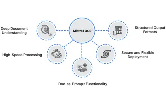 How to Use Mistral OCR for Your Next RAG Model
Mar 21, 2025 am 11:11 AM
How to Use Mistral OCR for Your Next RAG Model
Mar 21, 2025 am 11:11 AM
Mistral OCR: Revolutionizing Retrieval-Augmented Generation with Multimodal Document Understanding Retrieval-Augmented Generation (RAG) systems have significantly advanced AI capabilities, enabling access to vast data stores for more informed respons
