
 Technology peripherals
It Industry
my country launches key research and development plan: road traffic control and safety autonomous project
Technology peripherals
It Industry
my country launches key research and development plan: road traffic control and safety autonomous project
my country launches key research and development plan: road traffic control and safety autonomous project

The launch event of the National Key R&D Plan Autonomous Road Traffic Control and Safety Project was held on December 28 in Wuzhong District, Suzhou City.
The "Device-Network-Cloud Integrated Road Traffic All-Element Intelligent Control Technology" and "Autonomous Road Traffic System Safety Assurance Technology" projects under the national key research and development plan have been officially signed and launched. This project is led by the Road Traffic Safety Research Center of the Ministry of Public Security and the Traffic Management Science Institute of the Ministry of Public Security. At the same time, the autonomous driving traffic regulations compliance training (Suzhou) base project was also unveiled today.
Inquiries on this site found that China’s first holographic perception smart highway project that meets the vehicle-road collaborative autonomous driving level has been put into use in Suzhou. The project covers the Su-Taiwan Expressway S17 (Huangdai Interchange-Xiangcheng Hub) and the Shanghai-Yiyi Expressway S48 (Xiangcheng Hub-Yangcheng Hubei Interchange), with a total length of 56 kilometers. Among them, the road section capable of L4 level autonomous driving testing is 6.5 kilometers, which is located on the one-way section from Weitang Interchange to Xiangcheng Hub.
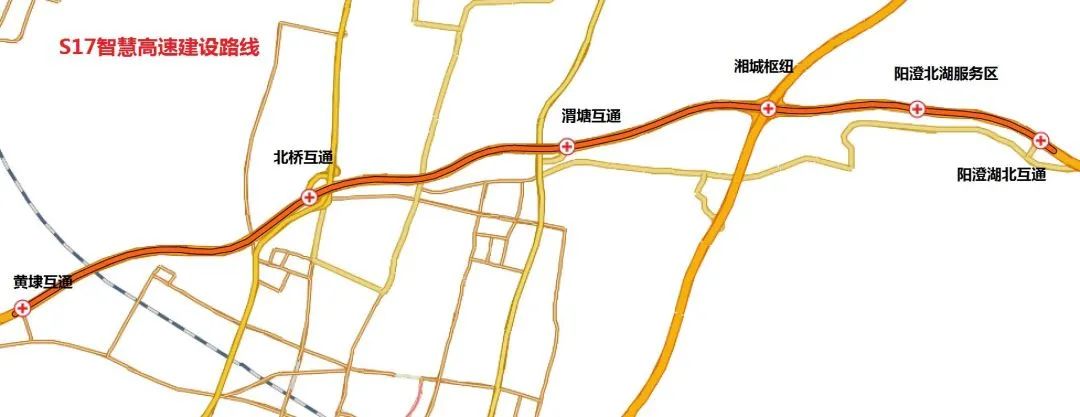
sensing equipment such as lidar, millimeter wave radar, camera, roadside antenna RSU, etc. have been deployed at 55 points to create Holographic sensing road sections and ramp (interchange) sensing road sections. The project passes through Beiqiao Interchange, Weitang Interchange, Xiangcheng Hub, and Yangcheng Beihu Service Area. The subdivided scenes along the line include toll stations, ramps, service areas, etc.
The holographic sensing road section is located on a 6.5-kilometer one-way section from Weitang Interchange to Xiangcheng Hub, with the direction from west to east. In this section of the road, two information prompt screens are set up, located at the entrance and middle of the holographic main road. In addition, laser radar, cameras and other equipment are deployed at an average of every 230 meters at each point. At the same time, a series of antenna RSUs are also set up on the roadside, with a distance of approximately 460 meters between each other. The sensing road section refers to a ramp (interchange) equipped with a series of devices that can sense vehicles entering and exiting the test road section. The main equipment of each sensing road section includes cameras, roadside antenna RSU, and millimeter wave radar. The function of these devices is to monitor and identify vehicles through different technical means, thereby achieving real-time perception and monitoring of the vehicle's driving status. Cameras can capture images and videos of vehicles, roadside antennas (RSUs) can receive and send vehicle communication data, and millimeter-wave radar can be used to measure information such as distance and speed of vehicles. Through the collaborative work of these devices, the sensing road section can accurately monitor and identify vehicles entering and exiting the test road section, providing important data support for traffic management and safety.
Photo source Pexels
 The Ministry of Industry and Information Technology and four other departments jointly issued a notice titled "About the Development of Intelligent Networked Vehicles" Notice on the Pilot Work on Access and Road Access. The notice pointed out that the pilot program for intelligent connected vehicle access and on-road access is to accelerate the promotion and application of intelligent connected vehicle products and ensure their safe operation. At the same time, the notice also proposes support for advanced autonomous driving technologies and products that have been piloted and proven, and plans to further promote them.
 The above is the detailed content of my country launches key research and development plan: road traffic control and safety autonomous project. For more information, please follow other related articles on the PHP Chinese website!

Hot AI Tools

Undresser.AI Undress
AI-powered app for creating realistic nude photos

AI Clothes Remover
Online AI tool for removing clothes from photos.

Undress AI Tool
Undress images for free

Clothoff.io
AI clothes remover

Video Face Swap
Swap faces in any video effortlessly with our completely free AI face swap tool!

Hot Article
Hot Tools

Notepad++7.3.1
Easy-to-use and free code editor

SublimeText3 Chinese version
Chinese version, very easy to use

Zend Studio 13.0.1
Powerful PHP integrated development environment

Dreamweaver CS6
Visual web development tools

SublimeText3 Mac version
God-level code editing software (SublimeText3)
Hot Topics


 Shanghai public transportation code goes online with 'Hong Kong version of Alipay' AlipayHK
Feb 07, 2024 pm 02:03 PM
Shanghai public transportation code goes online with 'Hong Kong version of Alipay' AlipayHK
Feb 07, 2024 pm 02:03 PM
The transportation card company under Shanghai Jiushi Group has cooperated with AlipayHK to launch a new "Shanghai Public Transportation Ride Code" service. This service provides non-mainland Chinese users with a convenient way to directly scan the QR code to ride. Starting from February 6, all users using AlipayHK can use this service to directly scan the QR code to pay fares on Shanghai buses, subways and other means of transportation, without the need to purchase physical transportation cards. This is the first convenient service provided to foreign tourists in Shanghai's public transportation sector, providing them with a more convenient and faster travel experience. Hong Kong friends in Shanghai can enjoy the same transfer discounts as mainland users, use AlipayHKApp to swipe QR codes for consumption, and take buses, ferries, Songjiang Rail and Jinshan Railway, which is convenient and fast.
 Highlights of new transportation along the southeast coast: The first train of the Guangzhou-Shantou High-speed Railway was successfully opened
Sep 26, 2023 pm 03:17 PM
Highlights of new transportation along the southeast coast: The first train of the Guangzhou-Shantou High-speed Railway was successfully opened
Sep 26, 2023 pm 03:17 PM
According to news on September 26, China’s high-speed rail network has welcomed a new member. This morning, Guangdong Province officially opened an important transportation infrastructure, and the Guangzhou-Shantou High-speed Railway began operation. The first G9726 high-speed rail train slowly started from Guangzhou East Railway Station at 8:30 a.m. and began a long journey. It passed through the newly built Guangzhou-Shantou High-speed Railway and successfully arrived at Shanwei Station about 73 minutes later. The Guangzhou-Shantou High-speed Railway has a total length of 200 kilometers and a design speed of With a speed of up to 350 km/h, there are a total of 8 stations on the line. Among them, Xintang Station is connected to the Guangzhou-Shenzhen Line 3 and 4 and is the main artery of the Guangzhou-Shenzhen Intercity Railway. The connection lines from Boluo to Huizhou North and Huizhou South to Zhongkai have enhanced connections with surrounding areas. It is understood that this project is not only a major transportation highlight in Guangdong Province, but also an important component of the high-speed rail corridor in China's southeast coast.
 Existing applications of drones in transportation
Dec 29, 2023 pm 06:10 PM
Existing applications of drones in transportation
Dec 29, 2023 pm 06:10 PM
With the rapid development of urbanization and the increasing demand for transportation, traffic drones, as an innovative technology, are gradually showing their unique application value in urban traffic management. This article will discuss in detail the current application status of drones in the transportation field, focusing on their achievements in traffic monitoring, accident site investigation, and traffic control and guidance. Traffic monitoring and management is an important task. It involves monitoring and managing traffic conditions on roads to ensure safe and smooth traffic flow. By installing cameras and other monitoring equipment, traffic conditions, including traffic flow, vehicle speeds and violations, can be monitored in real time. Monitoring centers can develop effective traffic management strategies by collecting and analyzing this data. Additionally, traffic lights and road signs can be used to
 Reduce traffic accidents, improve urban livability, and the 'wave” of autonomous driving is coming
Apr 12, 2023 pm 12:58 PM
Reduce traffic accidents, improve urban livability, and the 'wave” of autonomous driving is coming
Apr 12, 2023 pm 12:58 PM
Self-driving cars are able to accurately map their surroundings and monitor the location and real-time conditions of nearby vehicles, traffic lights, pedestrians, lane markings, etc. Current research shows that while significant improvements to each of these subsystems will still be needed to achieve fully functional, safe self-driving cars, once these milestone improvements are achieved, not only will people change the way their cars operate, they will also discover The implications extend far beyond self-driving cars. In a recent report, the American biweekly website Forbes looked forward to four ways in which self-driving cars are expected to change the future world. Reduce traffic accidents According to data provided by the World Health Organization, about 1.3 million people die in traffic accidents around the world every year, and this number may reach 220 in 2030.
 Can self-driving cars signal their intentions to pedestrians?
Apr 09, 2023 am 11:51 AM
Can self-driving cars signal their intentions to pedestrians?
Apr 09, 2023 am 11:51 AM
Determining whether a wide road can be safely crossed requires social cues and cooperative communication between pedestrians and drivers. So, what happens if it’s a self-driving vehicle? Self-driving car company Motional believes making vehicles more expressive may be the key to maintaining these important signals. While waiting at a crosswalk, Paul Schmitt, Motional's chief engineer, experienced what he calls "a dance of glances." It's a quick and almost subconscious assessment: Where are the drivers of oncoming cars looking? Did they notice him? “With self-driving vehicles, half of those interactions don’t exist,” Schmidt said. “So, what cues are there for pedestrians to understand the vehicle’s intentions?
 Will driverless driving be universal in ten years?
Apr 08, 2023 pm 10:41 PM
Will driverless driving be universal in ten years?
Apr 08, 2023 pm 10:41 PM
I saw this question on Zhihu: Will driverless driving be universal in ten years? And asked whether it is still necessary to learn a driver's license now. This is a very interesting question, because it involves the possibility of the commercialization of autonomous driving and how our lives will change after autonomous driving is implemented. This question also involves a concept, that is, universalization, which is also an issue worth discussing. Smart Driving Frontier will start from this issue and discuss it with everyone. Autonomous driving is related to smart travel, smart transportation, and smart cities. It is a major trend in future development and will also be a technological change that changes social lifestyles. Autonomous driving, in short, is the change in the role of car control. Now our travel process is completely inseparable from people.
 my country launches key research and development plan: road traffic control and safety autonomous project
Jan 03, 2024 pm 05:22 PM
my country launches key research and development plan: road traffic control and safety autonomous project
Jan 03, 2024 pm 05:22 PM
The launch event of the national key research and development plan autonomous road traffic control and safety project was held on December 28 in Wuzhong District, Suzhou City. The "Device-Network-Cloud Integrated Road Traffic All-Element Intelligent Control Technology" and "Autonomous Road Traffic System Safety Assurance Technology" projects of the national key research and development plan have been officially signed and launched. This project is led by the Road Traffic Safety Research Center of the Ministry of Public Security and the Traffic Management Science Institute of the Ministry of Public Security. At the same time, the autonomous driving traffic regulations compliance training (Suzhou) base project was also unveiled today. Inquiries on this site found that the country's first holographic sensing smart highway project that meets the vehicle-road collaborative autonomous driving level has been put into use in Suzhou. The project covers the Su-Taiwan Expressway S17 (Huangdai Interchange-Xiangcheng Hub) and the Shanghai-Yizhou Expressway S48 (
 Longzhong Bridge, the largest composite-girder single-tower cable-stayed bridge in my country, was successfully closed: the total length is 4,454 meters, the main span is 330 meters, and the main tower height is 201 meters.
Aug 05, 2024 pm 09:42 PM
Longzhong Bridge, the largest composite-girder single-tower cable-stayed bridge in my country, was successfully closed: the total length is 4,454 meters, the main span is 330 meters, and the main tower height is 201 meters.
Aug 05, 2024 pm 09:42 PM
According to news from this website on August 2, CCTV News reported yesterday (August 1) that the Longzhong Bridge (formerly known as the Niushou Han River Bridge) was successfully closed. The bridge is the largest span composite beam single-tower cable-stayed bridge in my country. Source: CCTV News Site Note: The Longzhong Bridge is constructed by China Communications Construction Company Second Harbor Engineering Co., Ltd. and is located in Xiangyang City, Hubei Province. It has a total length of 4,454 meters and two main spans of 330 meters. It is part of the Xiangyang 207 National Highway reconstruction project. The reconstruction project of the Xiangyang section of National Highway 207 starts from Huangji Town, Xiangzhou District, at the junction of Hubei and Henan provinces, and passes through 5 counties (cities and districts) of Xiangzhou, Fancheng, Xiangcheng, Nanzhang and Yicheng, with a total length of about 96 kilometers. It is the ordinary highway construction project with the longest construction mileage, largest investment scale and highest social attention in Xiangyang City. The design of Longzhong Bridge combines the historical and cultural heritage of Xiangyang. The main tower adopts the "H
