 Mobile Tutorial
 iPhone
 Discover the hidden features of iPhone 15: Find public transportation routes and other information in Maps!
Discover the hidden features of iPhone 15: Find public transportation routes and other information in Maps!
With the help of the iPhone 15’s own app “Map”, we can easily get detailed public transportation routes to our destinations. This includes important information such as subway and bus operating hours, departure times, transfer information and fares. Using this app, we can plan our trips more conveniently without missing any important information. Whether in the city or in a strange place, the "Map" application of iPhone 15 can be a powerful assistant for our travels.
The method for querying subway information is as follows:
If you want to check the subway operating time and detailed route, you can choose to click on the subway icon on the map, or use the search function to enter the keywords "subway" and The name of the site you want to query. This makes it easy to find the information you need. Whether you choose to click on the map icon or the search function, it can help you quickly obtain relevant information about subway operating times and detailed routes.

Check bus stops:
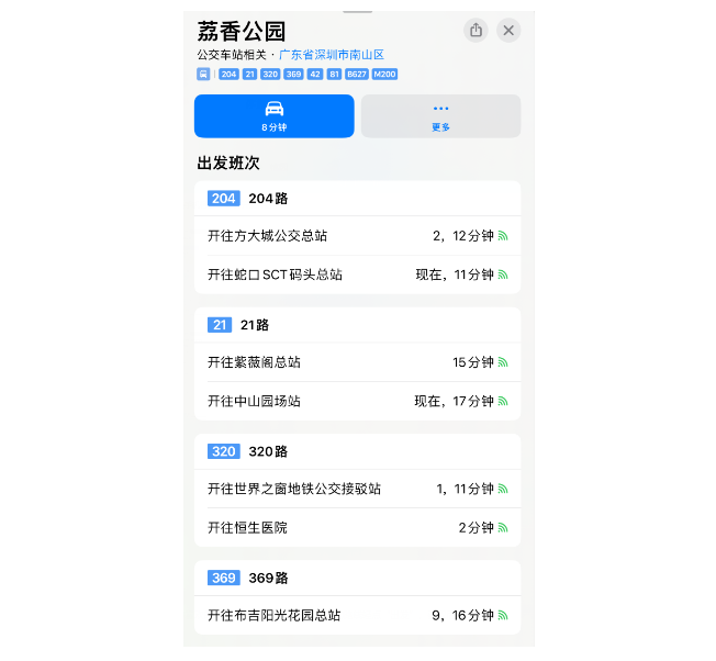
Search for the keyword "bus" on the map to find nearby bus stops. Click on any site to view information about buses.

By clicking on any vehicle information, you can easily view nearby departures and stops.

Provides public transportation information in specific areas. The specific functions vary according to the country or region.
Find public transportation routes:
You can do this by tapping a destination on the map (such as a search result or a landmark), or by pressing and holding anywhere on the map and tapping Directions button to select your preferred public transport route. Then, tap Go to get onward directions. This way, you can easily choose and get your preferred travel methods and route options.
Adding nearby public transportation to frequently used locations is a very useful feature. Whether in daily life or when traveling, we need to know the public transportation conditions nearby in time. By adding public transportation to frequently used locations, we can easily check nearby bus stations, subway stations and other transportation facilities and obtain relevant information in a timely manner. In this way, whether it is travel plans or daily commuting, we can plan routes and choose transportation more conveniently. Therefore, adding nearby public transportation to frequently used places is a very practical feature that is worth taking full advantage of when using map navigation software.
In the "Frequently Used Places" row on the search card, click the "Add" button, then click "Nearby Public Transportation," and finally click "Done." (If the "Add" button does not appear, slide the "Frequently Used Places" row to the left.)
When you use navigation software to find routes for designated transportation systems, sometimes you may receive a message, Tip: You can use Apple Pay to pay for public transportation, add transportation cards, or recharge transportation cards without opening the payment software or leaving the navigation software. This function is very convenient, eliminating the trouble of opening multiple applications, making it more convenient for you to travel.
The above is the detailed content of Discover the hidden features of iPhone 15: Find public transportation routes and other information in Maps!. For more information, please follow other related articles on the PHP Chinese website!

Hot AI Tools

Undresser.AI Undress
AI-powered app for creating realistic nude photos

AI Clothes Remover
Online AI tool for removing clothes from photos.

Undress AI Tool
Undress images for free

Clothoff.io
AI clothes remover

AI Hentai Generator
Generate AI Hentai for free.

Hot Article

Hot Tools

Notepad++7.3.1
Easy-to-use and free code editor

SublimeText3 Chinese version
Chinese version, very easy to use

Zend Studio 13.0.1
Powerful PHP integrated development environment

Dreamweaver CS6
Visual web development tools

SublimeText3 Mac version
God-level code editing software (SublimeText3)

Hot Topics
 Master the settings and usage skills of iPhone 15 Smart Island!
Jan 03, 2024 am 09:59 AM
Smart Island is a brand new UI element based on interactive design. It can show different forms and interaction methods according to the needs of different applications. On Smart Island, we can easily check the phone's face recognition, charging status, mute status, wireless transmission, and connected headphones to quickly understand the phone's information. After using the Smart Island function in various states, users can switch between applications and notifications more conveniently. In order to provide users with a new interactive experience, this year's Apple iPhone15 series all adopt the "Smart Island" design. If you have just purchased iPhone15, you can follow the editor to learn about the settings and usage of Apple iPhone15 Smart Island. Method 1: Adjust the display of iPhone15 Smart Island.
 What should I do if I can't turn off dark mode on iPhone 15? Six solutions to share!
Feb 28, 2024 pm 05:52 PM
Turning on the iPhone's dark mode in a dim environment or at night can effectively reduce eye fatigue, but some users have reported that their iPhone 15 cannot switch back to light mode after it is set to dark mode. If the iPhone 15 cannot turn off dark mode, please refer to the following methods to solve the problem: 1. Check whether the application supports light mode. To check whether the iPhone is in dark mode, you first need to confirm whether the application you are using supports light mode. Although most apps today support dark and light modes, there are still some apps that do not support light mode, such as Spotify, BeReal, and the default stock app on iPhone. Two: Try other ways to turn off dark mode if it doesn’t work
 What is the Apple 15ios version?
Mar 08, 2024 pm 05:07 PM
Apple 15 is the latest mobile phone launched by Apple. It will use the latest system version by default. If a user purchases an Apple 15 mobile phone, it will use the ios17 version from the factory. What is the iOS version of Apple 15? Answer: The system version 17 of iOS 17 will be pre-installed at the factory. Apple 15 is the latest mobile phone series launched by Apple, and the latest iOS system is pre-installed at the factory. 2. The iOS version of Apple 15 is iOS17.0.1, and the internal version number is 21A340. 3. The iOS17.0.2 update is available for iPhone15, 15Plus, iPhone15Pro and 15ProMax. 4. iOS17 will also support older versions and older models of Apple phones in the future.
 How to set the timer on and off on Xiaomi Mi 14?
Mar 18, 2024 pm 04:43 PM
Xiaomi Mi 14 is a powerful smartphone that offers many useful functions, including scheduled power on and off. This feature is undoubtedly very convenient for those users who want to automatically turn on and off the phone at a specific time. So, let’s take a look at how to set the timer on and off on Xiaomi Mi 14. How to set the timer on and off for Xiaomi Mi 14 1. Find the battery and performance options from the settings menu. 2. Select the battery section and click Scheduled Power On/Off. 3. Turn on the button on the right side of the scheduled power on, set the power on and off time, and finally click the check mark on the upper right. Now, you can easily control the power on and off time of your phone according to your needs. Whether it’s automatically turning your phone off when you go to bed at night or turning it on when you wake up in the morning
 Is iPhone 15 waterproof? iPhone 15 waterproof and dustproof rating
Feb 05, 2024 pm 02:45 PM
Today, smartphones have become an essential item in our lives. Therefore, designers continue to work hard to develop waterproof functions of mobile phones to deal with water damage. Water is very damaging to electronic equipment, and even a drop of water or accumulation of condensation can cause damage to the device. Water can cause electrical shorts that can damage delicate components. So placing your phone in a bowl of rice won't help repair the damage. Even if a device seems to survive, corrosion can quickly set in over the next few weeks or months and eventually destroy it. Therefore, it is crucial for electronic devices to avoid contact with water. When buying a new smartphone, it's crucial to make sure your new iPhone can withstand accidental drops. Its waterproof performance may also be the determining factor in the life of a mobile phone.
 Is it recommended to update iOS 17.4 for the iPhone 14 series?
Mar 14, 2024 pm 09:25 PM
The official version of iOS 17.4 has been released for more than a week, and many users have upgraded immediately! Apple's latest update introduces new emojis, adds text dictation capabilities to Apple Podcasts, and includes other features, bug fixes, and security updates designed specifically for iPhone. Apple recommends that all users upgrade as soon as possible to experience these new features and improve the security of their devices. Regarding the official version of iOS 17.4, the upgrade feedback from users of each model is different: From the upgrade feedback from netizens, we can see that the overall performance of the iOS 17.4 system may not be very good, especially for relatively older models. For users, the iOS17.4 system may consume more power than the iOS17.3.1 system. The editor also holds the iPhone in his hand
 iPhone15 dual SIM dual standby setup tutorial
Jan 12, 2024 am 10:24 AM
Recently, Apple’s newly launched iPhone15 series has been greatly welcomed by everyone. iPhone15 is equipped with a new A16 processor, which has powerful graphics processing capabilities and can easily handle various large-scale games and 4K video playback. The 12GB running memory and 512GB storage space are also a highlight, ensuring that the whole machine can run various applications smoothly. Apple iPhone 15 also adds a dual-SIM dual-standby function to meet the different needs of more users. The following is a tutorial for setting up dual-SIM dual-standby settings for iPhone 15: 1: When purchasing a dual-SIM dual-standby version of iPhone 15, make sure you buy a model that supports dual-SIM functionality. 2: Insert the SIM card and open the SIM card tray of the iPhone 15. The two SIM cards to be used will be
 How to turn photos into portraits after taking them with Apple iPhone 15
Feb 05, 2024 pm 06:48 PM
Portrait mode is a great way to take great photos with your iPhone 15, but what if you already have a photo you want to convert to portrait mode? Don't worry, it's easy to do! In this article, I will demonstrate how to turn ordinary pictures into portrait mode on iPhone15 series in a few steps. How to Convert Normal Photos to Portrait Mode on iPhone15 Series Launch the Photos app on iPhone. Select any regular photo of your choice. Click on the icon indicating the portrait symbol in the upper left corner. If you are editing a live photo, tap the live icon. Select Portrait to change. Wait a moment for the changes to take effect. If you change your mind, you can revert your changes by following the same steps. No, iPhone15 series


