 Technology peripherals
 AI
AI
 The world's first 'global ship footprint map” using AI to identify satellite images is completed
The world's first 'global ship footprint map” using AI to identify satellite images is completed

It was reported on January 4 that researcher David Kroodsma teamed up with National Geographic and Bloomberg Philanthropies to successfully build a global ship footprint map using satellite mapping data and AI technology. This map can accurately record various human activities in the ocean. The result is hailed as the world's first global ship footprint map.


In order to help players who have not yet passed the level, let us learn about the specific methods of solving the puzzle.
It is understood that the industry currently mainly uses VMS (Vessel Monitoring System, fishing vessel monitoring system) and AIS (Automatic Identification System, automatic identification system) to monitor the movements of global ships. However, these systems have limitations, such as equipment loading base and weather conditions, which make it difficult for them to accurately reflect global ship movements.
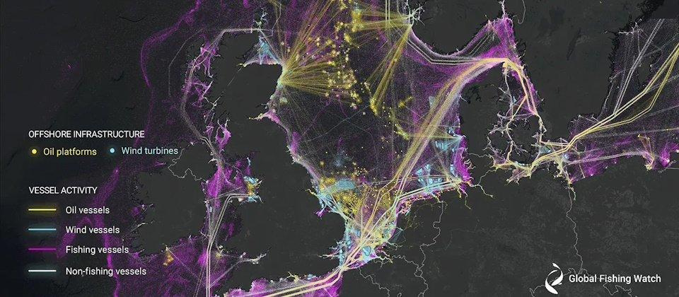
Researcher David Kroodsma used AI image recognition to train three AI models for detecting satellite images. They used global satellite data from 2017 to 2021 to build a relatively comprehensive map of ship footprints at sea.
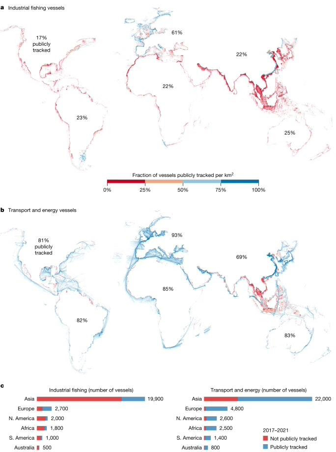
This site learned from the paper that this "Global Ship Footprint Map" shows that there are an average of 63,300 ships sailing at the same time around the world, but among them, "nearly 75% of fishing boats and nearly 25% of "Various ships" actually do not appear in the VMS and AIS ship detection systems, which shows that traditional ship identification systems are actually unable to accurately track global ship movements.


Additionally, researchers used AI to take stock of global offshore energy infrastructure, including the world’s largest concentration of offshore oil infrastructure In the North American Gulf of Mexico, the United States owns nearly 2,200 of them, accounting for 1/4 of the world's offshore oil infrastructure.
In terms of offshore wind power, researchers mentioned that the number of wind turbine generators in China increased by 900% from 2017 to 2022, the fastest growth rate in the world, with an average of 950 new units built every year, the number of wind turbines in the UK and Germany increased by only 49% and 28% respectively during the same period.
The above is the detailed content of The world's first 'global ship footprint map” using AI to identify satellite images is completed. For more information, please follow other related articles on the PHP Chinese website!

Hot AI Tools

Undresser.AI Undress
AI-powered app for creating realistic nude photos

AI Clothes Remover
Online AI tool for removing clothes from photos.

Undress AI Tool
Undress images for free

Clothoff.io
AI clothes remover

AI Hentai Generator
Generate AI Hentai for free.

Hot Article

Hot Tools

Notepad++7.3.1
Easy-to-use and free code editor

SublimeText3 Chinese version
Chinese version, very easy to use

Zend Studio 13.0.1
Powerful PHP integrated development environment

Dreamweaver CS6
Visual web development tools

SublimeText3 Mac version
God-level code editing software (SublimeText3)

Hot Topics
 How to output a countdown in C language
Apr 04, 2025 am 08:54 AM
How to output a countdown in C? Answer: Use loop statements. Steps: 1. Define the variable n and store the countdown number to output; 2. Use the while loop to continuously print n until n is less than 1; 3. In the loop body, print out the value of n; 4. At the end of the loop, subtract n by 1 to output the next smaller reciprocal.
 How to play picture sequences smoothly with CSS animation?
Apr 04, 2025 pm 05:57 PM
How to achieve the playback of pictures like videos? Many times, we need to implement similar video player functions, but the playback content is a sequence of images. direct...
 How to implement nesting effect of text annotations in Quill editor?
Apr 04, 2025 pm 05:21 PM
A solution to implement text annotation nesting in Quill Editor. When using Quill Editor for text annotation, we often need to use the Quill Editor to...
 Zustand asynchronous operation: How to ensure the latest state obtained by useStore?
Apr 04, 2025 pm 02:09 PM
Data update problems in zustand asynchronous operations. When using the zustand state management library, you often encounter the problem of data updates that cause asynchronous operations to be untimely. �...
 How to quickly build a foreground page in a React Vite project using AI tools?
Apr 04, 2025 pm 01:45 PM
How to quickly build a front-end page in back-end development? As a backend developer with three or four years of experience, he has mastered the basic JavaScript, CSS and HTML...
 Electron rendering process and WebView: How to achieve efficient 'synchronous' communication?
Apr 04, 2025 am 11:45 AM
Electron rendering process and WebView...
 How to use CSS to achieve smooth playback effect of image sequences?
Apr 04, 2025 pm 04:57 PM
How to realize the function of playing pictures like videos? Many times, we need to achieve similar video playback effects in the application, but the playback content is not...
 How to achieve the effect of high input elements but high text at the bottom?
Apr 04, 2025 pm 10:27 PM
How to achieve the height of the input element is very high but the text is located at the bottom. In front-end development, you often encounter some style adjustment requirements, such as setting a height...


