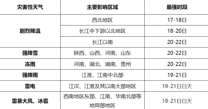
News from this site on February 16. According to the Central Meteorological Observatory, the cold wave weather is expected to affect the central and eastern regions of China from February 17 to 22. Most areas will drop by 10 to 18 degrees Celsius, and local temperatures will drop by up to 20 degrees Celsius. above. There will be obvious rain and snow weather in most parts of the country. Among them, Shaanxi, Shanxi, Henan, Shandong and other places will have blizzards, with severe localized blizzards; Henan, Hubei, Hunan, and Guizhou will have freezing rain one after another; there will be localized blizzards in the central and northern parts of Jianghuai and Jiangnan Heavy rain, widespread thunder and lightning and local strong convective weather in the south.

From the 16th to the 18th, before the main influence of the cold wave, most of the central and eastern parts Regional temperatures have risen significantly. Around the 19th, the daily maximum temperature in most of Jiangnan, southern China, Guizhou, Yunnan and other places was 25-28℃, and some areas in Jiangxi, Fujian and other places could reach around 30℃, approaching or exceeding the historical ten-day extreme.
From the 17th to the 22nd, most areas of our country will be affected by cold wave weather, and the temperature will gradually drop. The temperature drop in the northern region is 6 to 12°C, and some areas may drop by 12 to 18°C, especially Inner Mongolia, Northeast China, and central China. The temperature drop in some areas may even exceed 20°C. Around the 23rd, the minimum temperature line of 0℃ will compress southward, affecting the area from southern Jiangsu and Anhui to southern Hunan and southern Guizhou. Starting from the 24th, the temperature in the central and eastern regions will gradually rise, with the direction of recovery being from north to south.
Affected by the cold wave, winds in most areas of our country have gradually increased, with an average level of 4 to 6, and gusts of up to 7 to 9. Especially in the mountain passes of Xinjiang, the winds have become stronger, reaching about 12 levels. From the 19th to the 24th, strong winds of magnitude 6 to 8 occurred in the eastern and southern sea areas, with gusts up to magnitude 9 to 10.
Snowfall and freezing rain forecast: From the 18th to the 22nd, snowfall or freezing rain will occur successively in the eastern part of Northwest China, North China, Northeast China, Huanghuai, Jianghuai, Jianghan, northern and western Jiangnan, etc. Rain turns to snow, with heavy to heavy snowfall occurring in parts of Shaanxi, Shanxi, southern Hebei, Henan, Hubei, Shandong, central and northern Jiangsu and Anhui, southwestern Tibet, and southeastern Qinghai, with local heavy snowfall (accumulated snowfall of 8~ 15 mm, locally more than 20 mm; new snow depth of 5-12 cm, locally more than 15 cm); From the 20th to the 22nd, freezing rain will occur in Henan, Hubei, Hunan, and Guizhou from north to south.
Rainfall forecast: From the 18th to the 22nd, there will be moderate to heavy rains in Jianghan, Jianghuai, central and northern Jiangnan and other places, and local heavy rains (accumulated precipitation 50-80 mm, local 100 ~130 mm); rainfall in most areas is accompanied by thunder and lightning and short-term heavy rainfall (maximum hourly rainfall of 30-40 mm), and there are local strong convective weather such as hail or thunderstorm winds.
The above is the detailed content of The return trip from the Spring Festival will encounter another cold wave. From February 17th to 22nd, there will be severe cooling and widespread rain and snow in central and eastern my country.. For more information, please follow other related articles on the PHP Chinese website!


