 développement back-end
 Tutoriel Python
 Traiter les rasters multibandes (Sentinel-avec hndex et créer des index
Traiter les rasters multibandes (Sentinel-avec hndex et créer des index
Bonjour, Dans le blog précédent, nous avons expliqué comment effectuer une analyse raster à l'aide des index h3 et de postgresql pour un raster à bande unique. Dans ce blog, nous expliquerons comment traiter les rasters multicanaux et créer facilement des indices. Nous utiliserons l'image sentinelle-2, créerons un NDVI à partir des cellules h3 traitées et visualiserons les résultats
Télécharger les données de Sentinelle 2
Nous téléchargeons les données Sentinel 2 depuis https://apps.sentinel-hub.com/eo-browser/ à Pokhara, dans la région du Népal, juste pour nous assurer que le lac est dans la grille d'images afin que ce soit facile pour à nous de valider le résultat NDVI
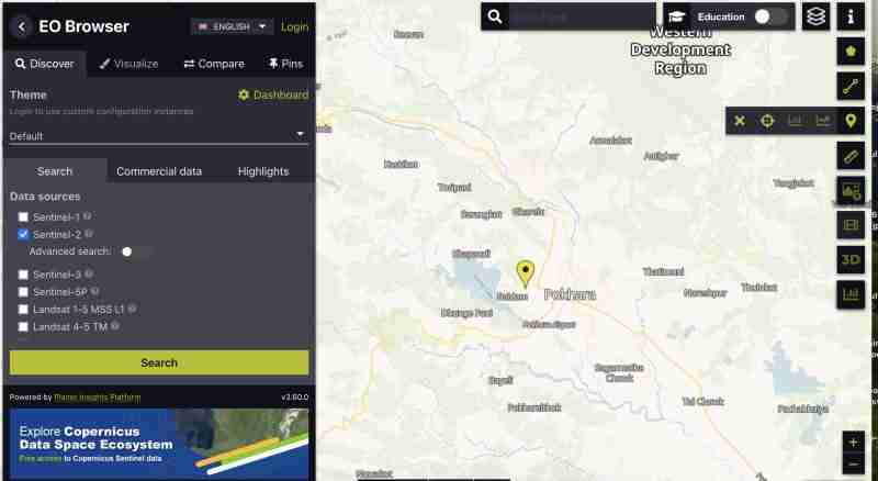
Pour télécharger l'image sentinelle avec toutes les bandes :
- Vous devez créer un compte
- Trouvez l'image dans votre zone sélectionnez la grille qui couvre votre zone d'intérêt
- Zoomez sur la grille, et cliquez sur l'icône
 sur la barre verticale droite
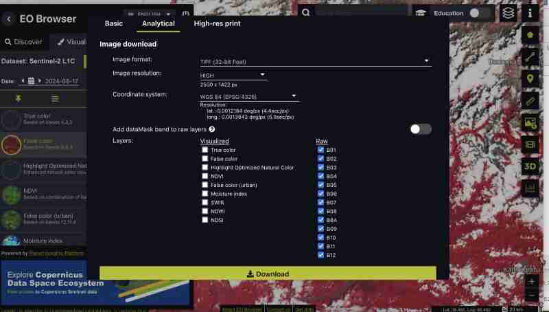
 - Après cela, allez dans l'onglet analytique et sélectionnez toutes les bandes avec un format d'image tiff 32 bits, haute résolution, format wgs1984 et toutes les bandes cochées
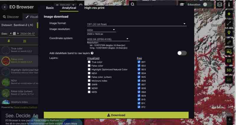
Vous pouvez également télécharger des indices prégénérés tels que NDVI, False Color Tiff uniquement ou des bandes spécifiques selon ce qui correspond le mieux à vos besoins. Nous téléchargeons toutes les bandes car nous voulons faire le traitement nous-mêmes
- Cliquez sur télécharger
Prétraitement
Nous obtenons tous les groupes sous forme de tiff séparé de la sentinelle au fur et à mesure que nous téléchargeons le format brut
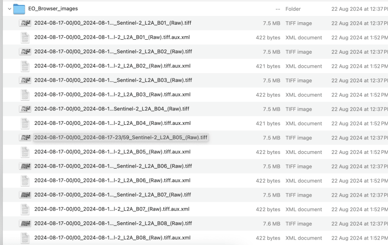
- créons une image composite :
Cela peut être fait via des outils SIG ou gdal
- Utilisation de gdal_merge :
Nous devons renommer le fichier téléchargé en band1,band2 comme ceci pour éviter les barres obliques dans le nom de fichier
Traitons jusqu'à la bande 9 pour cet exercice, vous pouvez choisir la bande selon vos besoins
gdal_merge.py -separate -o sentinel2_composite.tif band1.tif band2.tif band3.tif band4.tif band5.tif band6.tif band7.tif band8.tif band9.tif
- Utiliser QGIS :
- Charger toutes les bandes individuelles dans QGIS
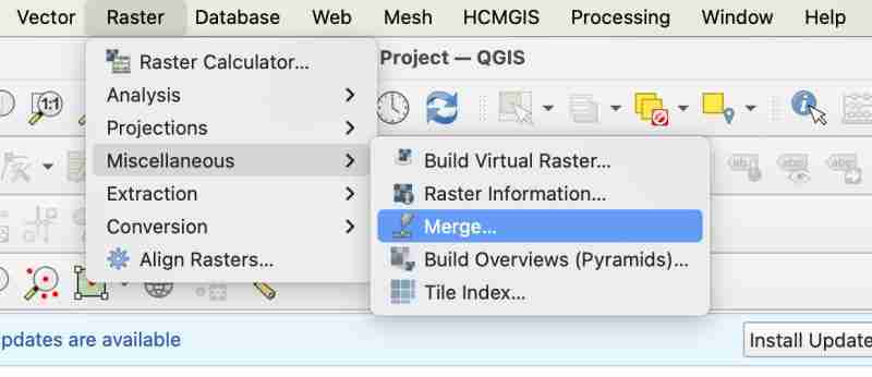
- Allez dans Raster > Divers > Fusionner
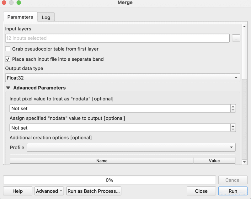
- Lors de la fusion, vous devez vous assurer de cocher « placer chaque fichier d'entrée dans la bande septembre »
- Exportez maintenant votre tiff fusionné vers un géotiff brut en tant que composite
Ménage
- Assurez-vous que votre image est en WGS1984 dans notre cas, l'image est déjà en ws1984 donc pas besoin de conversion
- Assurez-vous de ne pas avoir de nodata si oui remplissez-les avec 0
gdalwarp -overwrite -dstnodata 0 "$input_file" "${output_file}_nodata.tif"
- Enfin, assurez-vous que votre image de sortie est en COG
gdal_translate -of COG "$input_file" "$output_file"
J'utilise le script bash fourni dans le dépôt cog2h3 pour les automatiser
sudo bash pre.sh sentinel2_composite.tif
Processus et création de cellules h3
Maintenant, enfin, après avoir effectué le script de prétraitement, passons au calcul des cellules h3 pour chaque bande de l'image de rouage composite
- Installer cog2h3
pip install cog2h3
- Exportez vos informations d'identification de base de données
export DATABASE_URL="postgresql://user:password@host:port/database"
- Courir
Nous utilisons la résolution 10 pour cette image sentinelle, mais vous verrez également dans le script lui-même qui imprimera la résolution optimale pour votre raster qui rend la cellule h3 plus petite que votre plus petit pixel dans le raster.
cog2h3 --cog sentinel2_composite_preprocessed.tif --table sentinel --multiband --res 10
Il nous a fallu une minute pour calculer et stocker le résultat dans postgresql
Journaux :
2024-08-24 08:39:43,233 - INFO - Starting processing
2024-08-24 08:39:43,234 - INFO - COG file already exists at sentinel2_composite_preprocessed.tif
2024-08-24 08:39:43,234 - INFO - Processing raster file: sentinel2_composite_preprocessed.tif
2024-08-24 08:39:43,864 - INFO - Determined Min fitting H3 resolution for band 1: 11
2024-08-24 08:39:43,865 - INFO - Resampling original raster to: 200.786148m
2024-08-24 08:39:44,037 - INFO - Resampling Done for band 1
2024-08-24 08:39:44,037 - INFO - New Native H3 resolution for band 1: 10
2024-08-24 08:39:44,738 - INFO - Calculation done for res:10 band:1
2024-08-24 08:39:44,749 - INFO - Determined Min fitting H3 resolution for band 2: 11
2024-08-24 08:39:44,749 - INFO - Resampling original raster to: 200.786148m
2024-08-24 08:39:44,757 - INFO - Resampling Done for band 2
2024-08-24 08:39:44,757 - INFO - New Native H3 resolution for band 2: 10
2024-08-24 08:39:45,359 - INFO - Calculation done for res:10 band:2
2024-08-24 08:39:45,366 - INFO - Determined Min fitting H3 resolution for band 3: 11
2024-08-24 08:39:45,366 - INFO - Resampling original raster to: 200.786148m
2024-08-24 08:39:45,374 - INFO - Resampling Done for band 3
2024-08-24 08:39:45,374 - INFO - New Native H3 resolution for band 3: 10
2024-08-24 08:39:45,986 - INFO - Calculation done for res:10 band:3
2024-08-24 08:39:45,994 - INFO - Determined Min fitting H3 resolution for band 4: 11
2024-08-24 08:39:45,994 - INFO - Resampling original raster to: 200.786148m
2024-08-24 08:39:46,003 - INFO - Resampling Done for band 4
2024-08-24 08:39:46,003 - INFO - New Native H3 resolution for band 4: 10
2024-08-24 08:39:46,605 - INFO - Calculation done for res:10 band:4
2024-08-24 08:39:46,612 - INFO - Determined Min fitting H3 resolution for band 5: 11
2024-08-24 08:39:46,612 - INFO - Resampling original raster to: 200.786148m
2024-08-24 08:39:46,619 - INFO - Resampling Done for band 5
2024-08-24 08:39:46,619 - INFO - New Native H3 resolution for band 5: 10
2024-08-24 08:39:47,223 - INFO - Calculation done for res:10 band:5
2024-08-24 08:39:47,230 - INFO - Determined Min fitting H3 resolution for band 6: 11
2024-08-24 08:39:47,230 - INFO - Resampling original raster to: 200.786148m
2024-08-24 08:39:47,239 - INFO - Resampling Done for band 6
2024-08-24 08:39:47,239 - INFO - New Native H3 resolution for band 6: 10
2024-08-24 08:39:47,829 - INFO - Calculation done for res:10 band:6
2024-08-24 08:39:47,837 - INFO - Determined Min fitting H3 resolution for band 7: 11
2024-08-24 08:39:47,837 - INFO - Resampling original raster to: 200.786148m
2024-08-24 08:39:47,845 - INFO - Resampling Done for band 7
2024-08-24 08:39:47,845 - INFO - New Native H3 resolution for band 7: 10
2024-08-24 08:39:48,445 - INFO - Calculation done for res:10 band:7
2024-08-24 08:39:48,453 - INFO - Determined Min fitting H3 resolution for band 8: 11
2024-08-24 08:39:48,453 - INFO - Resampling original raster to: 200.786148m
2024-08-24 08:39:48,461 - INFO - Resampling Done for band 8
2024-08-24 08:39:48,461 - INFO - New Native H3 resolution for band 8: 10
2024-08-24 08:39:49,046 - INFO - Calculation done for res:10 band:8
2024-08-24 08:39:49,054 - INFO - Determined Min fitting H3 resolution for band 9: 11
2024-08-24 08:39:49,054 - INFO - Resampling original raster to: 200.786148m
2024-08-24 08:39:49,062 - INFO - Resampling Done for band 9
2024-08-24 08:39:49,063 - INFO - New Native H3 resolution for band 9: 10
2024-08-24 08:39:49,647 - INFO - Calculation done for res:10 band:9
2024-08-24 08:39:51,435 - INFO - Converting H3 indices to hex strings
2024-08-24 08:39:51,906 - INFO - Overall raster calculation done in 8 seconds
2024-08-24 08:39:51,906 - INFO - Creating or replacing table sentinel in database
2024-08-24 08:40:03,153 - INFO - Table sentinel created or updated successfully in 11.25 seconds.
2024-08-24 08:40:03,360 - INFO - Processing completed
Analyser
Puisque maintenant nous avons nos données dans postgresql, faisons quelques analyses
- Vérifiez que nous avons toutes les bandes que nous avons traitées (n'oubliez pas que nous avons traité des bandes 1 à 9)
select *
from sentinel

- Calculez le ndvi pour chaque cellule
explain analyze
select h3_ix , (band8-band4)/(band8+band4) as ndvi
from public.sentinel
Plan de requête :
QUERY PLAN                                                                                                       |
-----------------------------------------------------------------------------------------------------------------+
Seq Scan on sentinel  (cost=0.00..28475.41 rows=923509 width=16) (actual time=0.014..155.049 rows=923509 loops=1)|
Planning Time: 0.080 ms                                                                                          |
Execution Time: 183.764 ms                                                                                       |
As you can see here for all the rows in that area the calculation is instant . This is true for all other indices and you can compute complex indices join with other tables using the h3_ix primary key and derive meaningful result out of it without worrying as postgresql is capable of handling complex queries and table join.
Visualize and verification
Lets visualize and verify if the computed indices are true
- Create table ( for visualizing in QGIS )
create table ndvi_sentinel
as(
select h3_ix , (band8-band4)/(band8+band4) as ndvi
from public.sentinel )
- Lets add geometry to visualize the h3 cells This is only necessary to visualize in QGIS , if you build an minimal API by yourself you don't need this as you can construct geometry directly from query
ALTER TABLE ndvi_sentinel
ADD COLUMN geometry geometry(Polygon, 4326)
GENERATED ALWAYS AS (h3_cell_to_boundary_geometry(h3_ix)) STORED;
- Create index on geometry
create index on ndvi_sentinel(geometry);
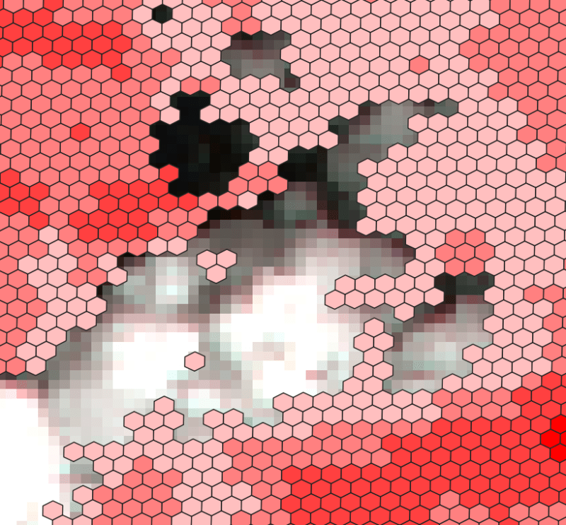
- Connect your database in QGIS and visualize the table on the basis of ndvi value Lets get the area near Fewa lake or cloud
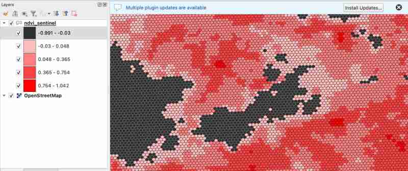
As we know value between -1.0 to 0.1 should represent Deep water or dense clouds
lets see if thats true ( making first category as transparent to see the underlying image )
- Check clouds :
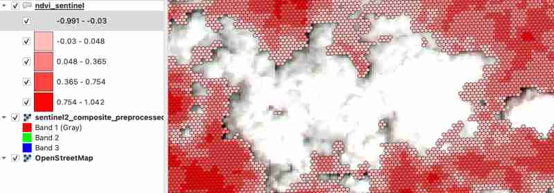
- Check Lake
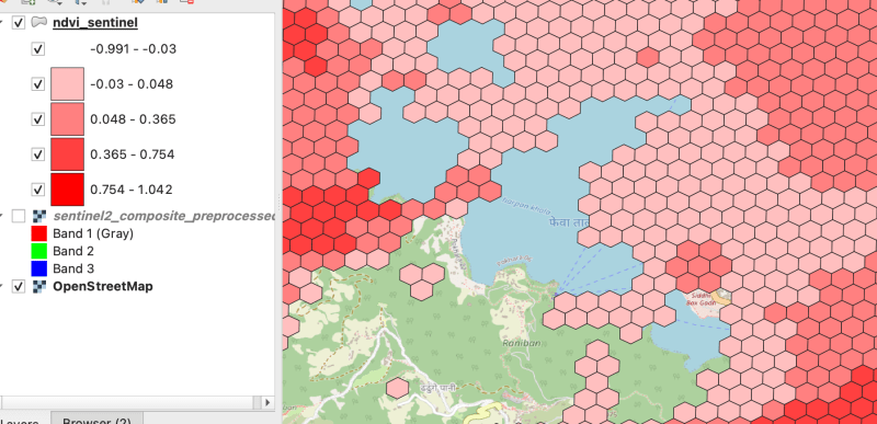
As there were clouds around the lake hence nearby fields are covered by cloud which makes sense
Thank you for reading ! See you in next blog
Ce qui précède est le contenu détaillé de. pour plus d'informations, suivez d'autres articles connexes sur le site Web de PHP en chinois!

Outils d'IA chauds

Undresser.AI Undress
Application basée sur l'IA pour créer des photos de nu réalistes

AI Clothes Remover
Outil d'IA en ligne pour supprimer les vêtements des photos.

Undress AI Tool
Images de déshabillage gratuites

Clothoff.io
Dissolvant de vêtements AI

Video Face Swap
Échangez les visages dans n'importe quelle vidéo sans effort grâce à notre outil d'échange de visage AI entièrement gratuit !

Article chaud

Outils chauds

Bloc-notes++7.3.1
Éditeur de code facile à utiliser et gratuit

SublimeText3 version chinoise
Version chinoise, très simple à utiliser

Envoyer Studio 13.0.1
Puissant environnement de développement intégré PHP

Dreamweaver CS6
Outils de développement Web visuel

SublimeText3 version Mac
Logiciel d'édition de code au niveau de Dieu (SublimeText3)

Sujets chauds
 1670
1670
 14
14
 1428
1428
 52
52
 1329
1329
 25
25
 1274
1274
 29
29
 1256
1256
 24
24
 Python vs C: courbes d'apprentissage et facilité d'utilisation
Apr 19, 2025 am 12:20 AM
Python est plus facile à apprendre et à utiliser, tandis que C est plus puissant mais complexe. 1. La syntaxe Python est concise et adaptée aux débutants. Le typage dynamique et la gestion automatique de la mémoire le rendent facile à utiliser, mais peuvent entraîner des erreurs d'exécution. 2.C fournit des fonctionnalités de contrôle de bas niveau et avancées, adaptées aux applications haute performance, mais a un seuil d'apprentissage élevé et nécessite une gestion manuelle de la mémoire et de la sécurité.
 Python et temps: tirer le meilleur parti de votre temps d'étude
Apr 14, 2025 am 12:02 AM
Pour maximiser l'efficacité de l'apprentissage de Python dans un temps limité, vous pouvez utiliser les modules DateTime, Time et Schedule de Python. 1. Le module DateTime est utilisé pour enregistrer et planifier le temps d'apprentissage. 2. Le module de temps aide à définir l'étude et le temps de repos. 3. Le module de planification organise automatiquement des tâches d'apprentissage hebdomadaires.
 Python vs. C: Explorer les performances et l'efficacité
Apr 18, 2025 am 12:20 AM
Python est meilleur que C dans l'efficacité du développement, mais C est plus élevé dans les performances d'exécution. 1. La syntaxe concise de Python et les bibliothèques riches améliorent l'efficacité du développement. Les caractéristiques de type compilation et le contrôle du matériel de CC améliorent les performances d'exécution. Lorsque vous faites un choix, vous devez peser la vitesse de développement et l'efficacité de l'exécution en fonction des besoins du projet.
 Apprendre Python: 2 heures d'étude quotidienne est-elle suffisante?
Apr 18, 2025 am 12:22 AM
Est-ce suffisant pour apprendre Python pendant deux heures par jour? Cela dépend de vos objectifs et de vos méthodes d'apprentissage. 1) Élaborer un plan d'apprentissage clair, 2) Sélectionnez les ressources et méthodes d'apprentissage appropriées, 3) la pratique et l'examen et la consolidation de la pratique pratique et de l'examen et de la consolidation, et vous pouvez progressivement maîtriser les connaissances de base et les fonctions avancées de Python au cours de cette période.
 Python vs C: Comprendre les principales différences
Apr 21, 2025 am 12:18 AM
Python et C ont chacun leurs propres avantages, et le choix doit être basé sur les exigences du projet. 1) Python convient au développement rapide et au traitement des données en raison de sa syntaxe concise et de son typage dynamique. 2) C convient à des performances élevées et à une programmation système en raison de son typage statique et de sa gestion de la mémoire manuelle.
 Quelle partie fait partie de la bibliothèque standard Python: listes ou tableaux?
Apr 27, 2025 am 12:03 AM
PythonlistSaReparmentofthestandardLibrary, tandis que les coloccules de colocède, tandis que les colocculations pour la base de la Parlementaire, des coloments de forage polyvalent, tandis que la fonctionnalité de la fonctionnalité nettement adressée.
 Python: automatisation, script et gestion des tâches
Apr 16, 2025 am 12:14 AM
Python excelle dans l'automatisation, les scripts et la gestion des tâches. 1) Automatisation: La sauvegarde du fichier est réalisée via des bibliothèques standard telles que le système d'exploitation et la fermeture. 2) Écriture de script: utilisez la bibliothèque PSUTIL pour surveiller les ressources système. 3) Gestion des tâches: utilisez la bibliothèque de planification pour planifier les tâches. La facilité d'utilisation de Python et la prise en charge de la bibliothèque riche en font l'outil préféré dans ces domaines.
 Python pour le développement Web: applications clés
Apr 18, 2025 am 12:20 AM
Les applications clés de Python dans le développement Web incluent l'utilisation des cadres Django et Flask, le développement de l'API, l'analyse et la visualisation des données, l'apprentissage automatique et l'IA et l'optimisation des performances. 1. Framework Django et Flask: Django convient au développement rapide d'applications complexes, et Flask convient aux projets petits ou hautement personnalisés. 2. Développement de l'API: Utilisez Flask ou DjangorestFramework pour construire RestulAPI. 3. Analyse et visualisation des données: utilisez Python pour traiter les données et les afficher via l'interface Web. 4. Apprentissage automatique et AI: Python est utilisé pour créer des applications Web intelligentes. 5. Optimisation des performances: optimisée par la programmation, la mise en cache et le code asynchrones


 sur la barre verticale droite