

2dsphere, GeoJSON, and Doctrine MongoDB

By Jeremy Mikola, 10gen software engineer and maintainer of Doctrine MongoDB ODM. It seems that GeoJSON is all the rage these days. Last month, Ian Bentley shared a bit about the new geospatial features in MongoDB 2.4. Derick Rethans, one
By Jeremy Mikola, 10gen software engineer and maintainer of Doctrine MongoDB ODM.
It seems that GeoJSON is all the rage these days. Last month, Ian Bentley shared a bit about the new geospatial features in MongoDB 2.4. Derick Rethans, one of my PHP driver teammates and a renowned OpenStreetMap aficionado, recently blogged about importing OSM data into MongoDB as GeoJSON objects. A few days later, GitHub added support for rendering .geojson files in repositories, using a combination of Leaflet.js, MapBox, and OpenStreetMap data. Coincidentally, I visited a local CloudCamp meetup last week to present on geospatial data, and for the past two weeks I’ve been working on adding support for MongoDB 2.4’s geospatial query operators to Doctrine MongoDB.
Doctrine MongoDB is an abstraction for the PHP driver that provides a fluent query builder API among other useful features. It’s used internally by Doctrine MongoDB ODM, but is completely usable on its own. One of the challenges in developing the library has been supporting multiple versions of MongoDB and the PHP driver. The introduction of read preferences last year is one such example. We wanted to still allow users to set slaveOk bits for older server and driver versions, but allow read preferences to apply for newer versions, all without breaking our API and abiding by semantic versioning. Now, the setSlaveOkay() method in Doctrine MongoDB will invoke setReadPreference() if it exists in the driver, and fall back to the deprecated setSlaveOkay() driver method otherwise.
Query Builder API
Before diving into the geospatial changes for Doctrine MongoDB, let’s take a quick look at the query builder API. Suppose we had a collection, test.places, with some OpenStreetMap annotations (key=value strings) stored in a tags array and a loc field containing longitude/latitude coordinates in MongoDB’s legacy point format (a float tuple) for a 2d index. Doctrine’s API allows queries to be constructed like so:
$connection = new \Doctrine\MongoDB\Connection();
    $collection = $connection->selectCollection('test', 'places');
    $qb = $collection->createQueryBuilder()
        ->field('loc')
            ->near(-73.987415, 40.757113)
            ->maxDistance(0.00899928);
        ->field('tags')
            ->equals('amenity=restaurant');
$cursor = $qb->getQuery()->execute();This above example executes the following query:
   {
        "loc": {
            "$near": [-73.987415, 40.757113],
            "$maxDistance": 0.00899928
        },
        "tags": "amenity=restaurant"
}This simple query will return restaurants within half a kilometer of 10gen’s NYC office at 229 West 43rd Street. If only it was so easy to find good restaurants near Times Square!
Supporting New and Old Geospatial Queries
When the new 2dsphere index type was introduced in MongoDB 2.4, operators such $near and $geoWithin were changed to accept GeoJSON geometry objects in addition to their legacy point and shape arguments. $near was particularly problematic because of its optional $maxDistance argument. As shown above, $maxDistance previously sat alongside $near and was measured in radians. It now sits within $near and is measured in meters. Using a 2dsphere index and GeoJSON points, the same query takes on a whole new shape:
   {
        "loc": {
            "$near": {
                "$geometry": {
                    "type": "Point",
                    "coordinates" [-73.987415, 40.757113]
                },
                "$maxDistance": 500
            }
        },
        "tags": "amenity=restaurant"
}This posed a hurdle for Doctrine MongoDB’s query builder, because we wanted to support 2dsphere queries without drastically changing the API. Unfortunately, there was no obvious way for near() to discern whether a pair of floats denoted a legacy or GeoJSON point, or whether a number signified radians or meters in the case of maxDistance(). I also anticipated we might run into a similar quandry for the $geoWithin builder method, which accepts an array of point coordinates.
Method overloading seemed preferable to creating separate builder methods or introducing a new “mode” parameter to handle 2dsphere queries. Although PHP has no language-level support for overloading, it is commonly implemented by inspecting an argument’s type at runtime. In our case, this would necessitate having classes for GeoJSON geometries (e.g. Point, LineString, Polygon), which we could differentiate from the legacy geometry arrays.
Introducing a GeoJSON Library for PHP
A cursory search for GeoJSON PHP libraries turned up php-geojson, from the MapFish project, and geoPHP. I was pleased to see that geoPHP was available via Composer (PHP’s de facto package manager), but neither library implemented the GeoJSON spec in its entirety. This seemed like a ripe opportunity to create such a library, and so geojson was born a few days later.
At the time of this writing, 2dsphere support for Doctrine’s query builder is still being developed; however, I envision it will take the following form when complete:
  use GeoJson\Geometry\Point;
    // ...
    $qb = $collection->createQueryBuilder()
        ->field('loc')
            ->near(new Point([-73.987415, 40.757113]))
            ->maxDistance(0.00899928);
        ->field('tags')
->equals('amenity=restaurant');All of the GeoJson classes implement JsonSerializable, one of the newer interfaces introduced in PHP 5.4, which will allow Doctrine to prepare them for MongoDB queries with a single method call. One clear benefit over the legacy geometry arrays is that the GeoJson library performs its own validation. When a Polygon is passed to geoWithin(), Doctrine won’t have to worry about whether all of its rings are closed LineStrings; the library would catch such an error in the constructor. This helps achieve a separation of concerns, which in turn increases the maintainability of both libraries.
I look forward to finishing up 2dsphere support for Doctrine MongoDB in the coming weeks. In the meantime, if you happen to fall in the fabled demographic of PHP developers in need of a full GeoJSON implementation, please give geojson a look and share some feedback.
原文地址:2dsphere, GeoJSON, and Doctrine MongoDB, 感谢原作者分享。

ホットAIツール

Undresser.AI Undress
リアルなヌード写真を作成する AI 搭載アプリ

AI Clothes Remover
写真から衣服を削除するオンライン AI ツール。

Undress AI Tool
脱衣画像を無料で

Clothoff.io
AI衣類リムーバー

Video Face Swap
完全無料の AI 顔交換ツールを使用して、あらゆるビデオの顔を簡単に交換できます。

人気の記事
ホットツール

メモ帳++7.3.1
使いやすく無料のコードエディター

SublimeText3 中国語版
中国語版、とても使いやすい

ゼンドスタジオ 13.0.1
強力な PHP 統合開発環境

ドリームウィーバー CS6
ビジュアル Web 開発ツール

SublimeText3 Mac版
神レベルのコード編集ソフト(SublimeText3)
ホットトピック
 7859
7859
 15
1649
14
1403
52
1300
25
1242
29
15
1649
14
1403
52
1300
25
1242
29

 MySQLでインデックスを使用するよりも、フルテーブルスキャンがいつ速くなるのでしょうか?
Apr 09, 2025 am 12:05 AM
MySQLでインデックスを使用するよりも、フルテーブルスキャンがいつ速くなるのでしょうか?
Apr 09, 2025 am 12:05 AM
完全なテーブルスキャンは、MySQLでインデックスを使用するよりも速い場合があります。特定のケースには以下が含まれます。1)データボリュームは小さい。 2)クエリが大量のデータを返すとき。 3)インデックス列が高度に選択的でない場合。 4)複雑なクエリの場合。クエリプランを分析し、インデックスを最適化し、オーバーインデックスを回避し、テーブルを定期的にメンテナンスすることにより、実際のアプリケーションで最良の選択をすることができます。
 Windows 7にMySQLをインストールできますか?
Apr 08, 2025 pm 03:21 PM
Windows 7にMySQLをインストールできますか?
Apr 08, 2025 pm 03:21 PM
はい、MySQLはWindows 7にインストールできます。MicrosoftはWindows 7のサポートを停止しましたが、MySQLは引き続き互換性があります。ただし、インストールプロセス中に次のポイントに注意する必要があります。WindowsのMySQLインストーラーをダウンロードしてください。 MySQL(コミュニティまたはエンタープライズ)の適切なバージョンを選択します。インストールプロセス中に適切なインストールディレクトリと文字セットを選択します。ルートユーザーパスワードを設定し、適切に保ちます。テストのためにデータベースに接続します。 Windows 7の互換性とセキュリティの問題に注意してください。サポートされているオペレーティングシステムにアップグレードすることをお勧めします。
 INNODBフルテキスト検索機能を説明します。
Apr 02, 2025 pm 06:09 PM
INNODBフルテキスト検索機能を説明します。
Apr 02, 2025 pm 06:09 PM
INNODBのフルテキスト検索機能は非常に強力であり、データベースクエリの効率と大量のテキストデータを処理する能力を大幅に改善できます。 1)INNODBは、倒立インデックスを介してフルテキスト検索を実装し、基本的および高度な検索クエリをサポートします。 2)一致を使用してキーワードを使用して、ブールモードとフレーズ検索を検索、サポートします。 3)最適化方法には、単語セグメンテーションテクノロジーの使用、インデックスの定期的な再構築、およびパフォーマンスと精度を改善するためのキャッシュサイズの調整が含まれます。
 INNODBのクラスターインデックスと非クラスターインデックス(セカンダリインデックス)の違い。
Apr 02, 2025 pm 06:25 PM
INNODBのクラスターインデックスと非クラスターインデックス(セカンダリインデックス)の違い。
Apr 02, 2025 pm 06:25 PM
クラスター化されたインデックスと非クラスター化されたインデックスの違いは次のとおりです。1。クラスター化されたインデックスは、インデックス構造にデータを保存します。これは、プライマリキーと範囲でクエリするのに適しています。 2.非クラスター化されたインデックスストアは、インデックスキー値とデータの行へのポインターであり、非プリマリーキー列クエリに適しています。
 MySQL:簡単な学習のためのシンプルな概念
Apr 10, 2025 am 09:29 AM
MySQL:簡単な学習のためのシンプルな概念
Apr 10, 2025 am 09:29 AM
MySQLは、オープンソースのリレーショナルデータベース管理システムです。 1)データベースとテーブルの作成:createdatabaseおよびcreateTableコマンドを使用します。 2)基本操作:挿入、更新、削除、選択。 3)高度な操作:参加、サブクエリ、トランザクション処理。 4)デバッグスキル:構文、データ型、およびアクセス許可を確認します。 5)最適化の提案:インデックスを使用し、選択*を避け、トランザクションを使用します。
 mysqlとmariadbは共存できますか
Apr 08, 2025 pm 02:27 PM
mysqlとmariadbは共存できますか
Apr 08, 2025 pm 02:27 PM
MySQLとMariaDBは共存できますが、注意して構成する必要があります。重要なのは、さまざまなポート番号とデータディレクトリを各データベースに割り当て、メモリ割り当てやキャッシュサイズなどのパラメーターを調整することです。接続プーリング、アプリケーションの構成、およびバージョンの違いも考慮する必要があり、落とし穴を避けるために慎重にテストして計画する必要があります。 2つのデータベースを同時に実行すると、リソースが制限されている状況でパフォーマンスの問題を引き起こす可能性があります。
 MySQLユーザーとデータベースの関係
Apr 08, 2025 pm 07:15 PM
MySQLユーザーとデータベースの関係
Apr 08, 2025 pm 07:15 PM
MySQLデータベースでは、ユーザーとデータベースの関係は、アクセス許可と表によって定義されます。ユーザーには、データベースにアクセスするためのユーザー名とパスワードがあります。許可は助成金コマンドを通じて付与され、テーブルはCreate Tableコマンドによって作成されます。ユーザーとデータベースの関係を確立するには、データベースを作成し、ユーザーを作成してから許可を付与する必要があります。
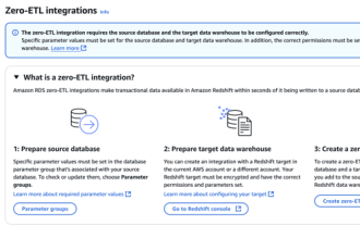 RDS MySQL Redshift Zero ETLとの統合
Apr 08, 2025 pm 07:06 PM
RDS MySQL Redshift Zero ETLとの統合
Apr 08, 2025 pm 07:06 PM
データ統合の簡素化:AmazonrdsmysqlとRedshiftのゼロETL統合効率的なデータ統合は、データ駆動型組織の中心にあります。従来のETL(抽出、変換、負荷)プロセスは、特にデータベース(AmazonrdsmysQlなど)をデータウェアハウス(Redshiftなど)と統合する場合、複雑で時間がかかります。ただし、AWSは、この状況を完全に変えたゼロETL統合ソリューションを提供し、RDSMYSQLからRedshiftへのデータ移行のための簡略化されたほぼリアルタイムソリューションを提供します。この記事では、RDSMysQl Zero ETLのRedshiftとの統合に飛び込み、それがどのように機能するか、それがデータエンジニアと開発者にもたらす利点を説明します。
