

HTML5 가이드 (4) - Geolocation 사용에 대한 자세한 설명

오늘 배울 내용은 Geolocation을 활용하여 위치 확인 기능을 구현하는 것입니다. 다음 메소드를 제공하는 navigator.geolocation을 통해 Geolocation 객체를 가져올 수 있습니다.
getCurrentPosition(callback,errorCallback,options): 현재 위치 가져오기
watchPosition(callback,error,options) ): 현재 위치 모니터링을 시작합니다.
clearWatch(id): 현재 위치 모니터링을 중지합니다.
참고: 아래 예시에 사용된 브라우저는 크롬입니다. 다른 브라우저를 사용하는 경우 실행 결과가 예시에 표시된 결과와 일치한다고 보장할 수 없습니다.
1. 현재 위치 가져오기
현재 위치를 가져오기 위해 getCurrentPosition 메서드를 사용합니다. 위치 정보는 직접 반환되지 않습니다. 결과 형태로 처리하려면 콜백 함수를 사용해야 합니다. 좌표를 가져오는 데 약간의 지연이 있을 수 있으며, 액세스 권한을 묻는 메시지가 표시됩니다. 다음 예를 살펴보겠습니다.
<!DOCTYPE HTML><html><head>
<title>Example</title>
<style>
table{border-collapse: collapse;}
th, td{padding: 4px;}
th{text-align: right;}
</style></head><body>
<table border="1">
<tr>
<th>Longitude:</th>
<td id="longitude">-</td>
<th>Latitude:</th>
<td id="latitude">-</td>
</tr>
<tr>
<th>Altitude:</th>
<td id="altitude">-</td>
<th>Accuracy:</th>
<td id="accuracy">-</td>
</tr>
<tr>
<th>Altitude Accuracy:</th>
<td id="altitudeAccuracy">-</td>
<th>Heading:</th>
<td id="heading">-</td>
</tr>
<tr>
<th>Speed:</th>
<td id="speed">-</td>
<th>Time Stamp:</th>
<td id="timestamp">-</td>
</tr>
</table>
<script>
navigator.geolocation.getCurrentPosition(displayPosition);
function displayPosition(pos) {
var properties = ['longitude', 'latitude', 'altitude', 'accuracy', 'altitudeAccuracy', 'heading', 'speed'];
for (var i = 0, len = properties.length; i < len; i++) {
var value = pos.coords[properties[i]];
document.getElementById(properties[i]).innerHTML = value;
}
document.getElementById('timestamp').innerHTML = pos.timestamp;
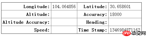
} </script></body></html>반환된 위치 객체에는 두 개의 속성 이 포함되어 있습니다. coords: 좌표 정보를 반환합니다. 타임스탬프: 좌표 정보를 얻은 시간입니다. 그 중 좌표에는 다음 속성이 포함됩니다: 위도: 고도, 정확도: 고도 정확도(미터), 이동 속도(미터/ 두번째) .
브라우저를 호스팅하는 기기에 따라 모든 정보가 반환되지는 않습니다. GPS, 가속도계, 나침반이 장착된 모바일 장치는 대부분의 정보를 반환하지만 가정용 컴퓨터는 그렇지 않습니다. 집에 있는 컴퓨터에서 얻는 위치정보는 네트워크 환경이나 if에 따라 다릅니다. 위 예제의 결과를 살펴보겠습니다.
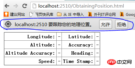
좌표 정보를 얻으려면 허용을 클릭하세요.
2. 예외 처리
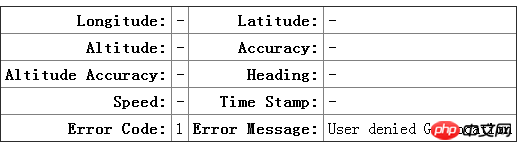
이제 getCurrentPosition의 예외 처리를 소개합니다. errorCallback을 사용하여 콜백 함수를 구현했습니다. 함수에서 반환된 오류 매개변수에는 코드: 오류 유형 코드, 메시지: 오류 메시지라는 두 가지 속성이 포함되어 있습니다. 코드에는 세 가지 값이 포함되어 있습니다. 1: 사용자에게 지리적 위치를 사용할 권한이 없습니다. 2: 좌표 정보를 얻을 수 없습니다. 3: 정보를 얻는 데 시간이 초과되었습니다.
아래 예를 살펴보겠습니다.
<!DOCTYPE HTML><html><head>
    <title>Example</title>
    <style>
        table{border-collapse: collapse;}
        th, td{padding: 4px;}
        th{text-align: right;}
    </style></head><body>
    <table border="1">
        <tr>
            <th>Longitude:</th>
            <td id="longitude">-</td>
            <th>Latitude:</th>
            <td id="latitude">-</td>
        </tr>
        <tr>
            <th>Altitude:</th>
            <td id="altitude">-</td>
            <th>Accuracy:</th>
            <td id="accuracy">-</td>
        </tr>
        <tr>
            <th>Altitude Accuracy:</th>
            <td id="altitudeAccuracy">-</td>
            <th>Heading:</th>
            <td id="heading">-</td>
        </tr>
        <tr>
            <th>Speed:</th>
            <td id="speed">-</td>
            <th>Time Stamp:</th>
            <td id="timestamp">-</td>
        </tr>
        <tr>
            <th>Error Code:</th>
            <td id="errcode">-</td>
            <th>Error Message:</th>
            <td id="errmessage">-</td>
        </tr>
    </table>
    <script>
        navigator.geolocation.getCurrentPosition(displayPosition, handleError);
        function displayPosition(pos) {
        var properties = ["longitude", "latitude", "altitude", "accuracy", "altitudeAccuracy", "heading", "speed"];
        for (var i = 0; i < properties.length; i++) {
        var value = pos.coords[properties[i]];
                document.getElementById(properties[i]).innerHTML = value;
            }
            document.getElementById("timestamp").innerHTML = pos.timestamp;
        }        function handleError(err) {
            document.getElementById("errcode").innerHTML = err.code;
            document.getElementById("errmessage").innerHTML = err.message;
} </script></body></html>승인 거부, 실행 결과:
3. 지리적 위치 선택적 매개변수 사용
getCurrentPosition(callback,errorCallback,options)의 옵션에는 사용할 수 있는 다음 매개변수가 있습니다. maximumAge : 캐싱 시간(밀리초)을 지정합니다. 다음 예를 들어보겠습니다.
<!DOCTYPE HTML><html><head>
    <title>Example</title>
    <style>
        table{border-collapse: collapse;}
        th, td{padding: 4px;}
        th{text-align: right;}
    </style></head><body>
    <table border="1">
        <tr>
            <th>Longitude:</th>
            <td id="longitude">-</td>
            <th>Latitude:</th>
            <td id="latitude">-</td>
        </tr>
        <tr>
            <th>Altitude:</th>
            <td id="altitude">-</td>
            <th>Accuracy:</th>
            <td id="accuracy">-</td>
        </tr>
        <tr>
            <th>Altitude Accuracy:</th>
            <td id="altitudeAccuracy">-</td>
            <th>Heading:</th>
            <td id="heading">-</td>
        </tr>
        <tr>
            <th>Speed:</th>
            <td id="speed">-</td>
            <th>Time Stamp:</th>
            <td id="timestamp">-</td>
        </tr>
        <tr>
            <th>Error Code:</th>
            <td id="errcode">-</td>
            <th>Error Message:</th>
            <td id="errmessage">-</td>
        </tr>
    </table>
    <script>
        var options = {
            enableHighAccuracy: false,
            timeout: 2000,
            maximumAge: 30000
        };
        navigator.geolocation.getCurrentPosition(displayPosition, handleError, options);
        function displayPosition(pos) {
        var properties = ["longitude", "latitude", "altitude", "accuracy", "altitudeAccuracy", "heading", "speed"];
        for (var i = 0; i < properties.length; i++) {
        var value = pos.coords[properties[i]];
                document.getElementById(properties[i]).innerHTML = value;
            }
            document.getElementById("timestamp").innerHTML = pos.timestamp;
        }        function handleError(err) {
            document.getElementById("errcode").innerHTML = err.code;
            document.getElementById("errmessage").innerHTML = err.message;
} </script></body></html>4. 위치 변경 모니터링
아래에서는 watchPosition 메서드를 사용하여 위치 변경을 모니터링하는 방법을 소개합니다. . 예를 살펴보겠습니다.
<!DOCTYPE HTML><html><head>
    <title>Example</title>
    <style>
        table{border-collapse: collapse;}
        th, td{padding: 4px;}
        th{text-align: right;}
    </style></head><body>
    <table border="1">
        <tr>
            <th>Longitude:</th>
            <td id="longitude">-</td>
            <th>Latitude:</th>
            <td id="latitude">-</td>
        </tr>
        <tr>
            <th>Altitude:</th>
            <td id="altitude">-</td>
            <th>Accuracy:</th>
            <td id="accuracy">-</td>
        </tr>
        <tr>
            <th>Altitude Accuracy:</th>
            <td id="altitudeAccuracy">-</td>
            <th>Heading:</th>
            <td id="heading">-</td>
        </tr>
        <tr>
            <th>Speed:</th>
            <td id="speed">-</td>
            <th>Time Stamp:</th>
            <td id="timestamp">-</td>
        </tr>
        <tr>
            <th>Error Code:</th>
            <td id="errcode">-</td>
            <th>Error Message:</th>
            <td id="errmessage">-</td>
        </tr>
    </table>
    <button id="pressme">Cancel Watch</button>
    <script>
        var options = {
            enableHighAccuracy: false,
            timeout: 2000,
            maximumAge: 30000
        };        var watchID = navigator.geolocation.watchPosition(displayPosition, handleError, options);

        document.getElementById("pressme").onclick = function (e) {
            navigator.geolocation.clearWatch(watchID);
        };        function displayPosition(pos) {
        var properties = ["longitude", "latitude", "altitude", "accuracy", "altitudeAccuracy", "heading", "speed"];
        for (var i = 0; i < properties.length; i++) {
        var value = pos.coords[properties[i]];
                document.getElementById(properties[i]).innerHTML = value;
            }
            document.getElementById("timestamp").innerHTML = pos.timestamp;
        }        function handleError(err) {
            document.getElementById("errcode").innerHTML = err.code;
            document.getElementById("errmessage").innerHTML = err.message;
} </script></body></html>위 내용은 HTML5 가이드 (4) - Geolocation 사용에 대한 자세한 설명의 상세 내용입니다. 자세한 내용은 PHP 중국어 웹사이트의 기타 관련 기사를 참조하세요!

핫 AI 도구

Undresser.AI Undress
사실적인 누드 사진을 만들기 위한 AI 기반 앱

AI Clothes Remover
사진에서 옷을 제거하는 온라인 AI 도구입니다.

Undress AI Tool
무료로 이미지를 벗다

Clothoff.io
AI 옷 제거제

AI Hentai Generator
AI Hentai를 무료로 생성하십시오.

인기 기사
뜨거운 도구

메모장++7.3.1
사용하기 쉬운 무료 코드 편집기

SublimeText3 중국어 버전
중국어 버전, 사용하기 매우 쉽습니다.

스튜디오 13.0.1 보내기
강력한 PHP 통합 개발 환경

드림위버 CS6
시각적 웹 개발 도구

SublimeText3 Mac 버전
신 수준의 코드 편집 소프트웨어(SublimeText3)
뜨거운 주제
 7518
7518
 15
1378
52
81
11
53
19
21
68
15
1378
52
81
11
53
19
21
68

 HTML의 테이블 테두리
Sep 04, 2024 pm 04:49 PM
HTML의 테이블 테두리
Sep 04, 2024 pm 04:49 PM
HTML의 테이블 테두리 안내. 여기에서는 HTML의 테이블 테두리 예제를 사용하여 테이블 테두리를 정의하는 여러 가지 방법을 논의합니다.
 HTML 여백-왼쪽
Sep 04, 2024 pm 04:48 PM
HTML 여백-왼쪽
Sep 04, 2024 pm 04:48 PM
HTML 여백-왼쪽 안내. 여기에서는 HTML margin-left에 대한 간략한 개요와 코드 구현과 함께 예제를 논의합니다.
 HTML의 중첩 테이블
Sep 04, 2024 pm 04:49 PM
HTML의 중첩 테이블
Sep 04, 2024 pm 04:49 PM
HTML의 Nested Table에 대한 안내입니다. 여기에서는 각 예와 함께 테이블 내에 테이블을 만드는 방법을 설명합니다.
 HTML 테이블 레이아웃
Sep 04, 2024 pm 04:54 PM
HTML 테이블 레이아웃
Sep 04, 2024 pm 04:54 PM
HTML 테이블 레이아웃 안내. 여기에서는 HTML 테이블 레이아웃의 값에 대해 예제 및 출력 n 세부 사항과 함께 논의합니다.
 HTML 입력 자리 표시자
Sep 04, 2024 pm 04:54 PM
HTML 입력 자리 표시자
Sep 04, 2024 pm 04:54 PM
HTML 입력 자리 표시자 안내. 여기서는 코드 및 출력과 함께 HTML 입력 자리 표시자의 예를 논의합니다.
 HTML 정렬 목록
Sep 04, 2024 pm 04:43 PM
HTML 정렬 목록
Sep 04, 2024 pm 04:43 PM
HTML 순서 목록에 대한 안내입니다. 여기서는 HTML Ordered 목록 및 유형에 대한 소개와 각각의 예에 대해서도 설명합니다.
 HTML에서 텍스트 이동
Sep 04, 2024 pm 04:45 PM
HTML에서 텍스트 이동
Sep 04, 2024 pm 04:45 PM
HTML에서 텍스트 이동 안내. 여기서는 Marquee 태그가 구문과 함께 작동하는 방식과 구현할 예제에 대해 소개합니다.
 HTML 온클릭 버튼
Sep 04, 2024 pm 04:49 PM
HTML 온클릭 버튼
Sep 04, 2024 pm 04:49 PM
HTML onclick 버튼에 대한 안내입니다. 여기에서는 각각의 소개, 작업, 예제 및 다양한 이벤트의 onclick 이벤트에 대해 설명합니다.
