

Python을 사용하여 사진 촬영 시 자세한 위치를 얻는 방법

一.引言
我们的朋友给我们发来一张照片我们如何获取到她的位置呢?
用手机拍照会带着GPS信息,原来没注意过这个,因此查看下并使用代码获取照片里的GPS信息
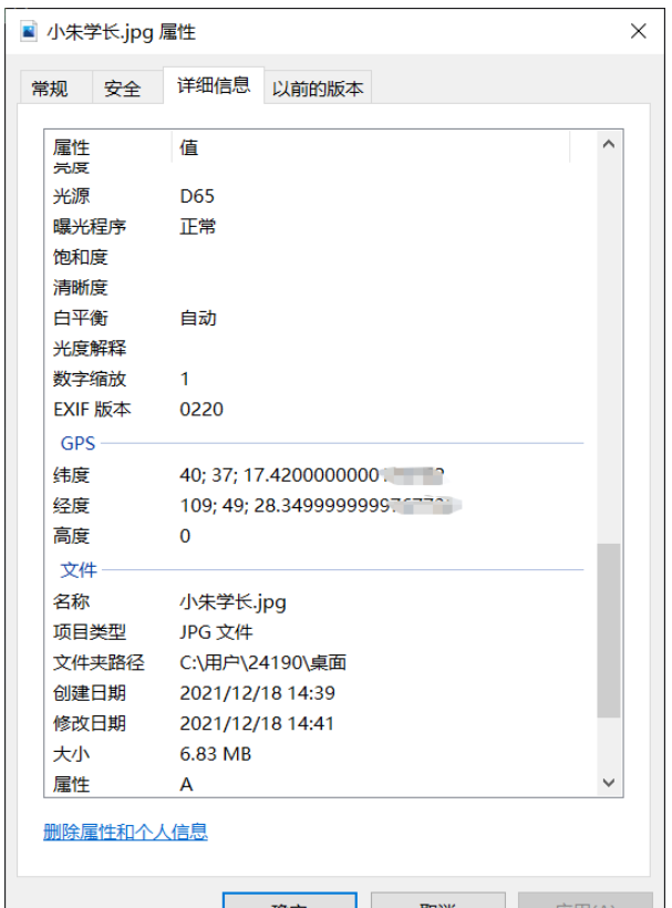
查看图片文件属性
1.读取照片信息,获取坐标
ExifRead
Python library to extract EXIF data from tiff and jpeg files.
安装
pip install exifread
读取GPS
import exifread
import re

def read():
    GPS = {}
    date = ''
    f = open("C:\\Users\\24190\\Desktop\\小朱学长.jpg",'rb')
    contents = exifread.process_file(f)
    for key in contents:
        if key == "GPS GPSLongitude":
            print("经度 =", contents[key],contents['GPS GPSLatitudeRef'])
        elif key =="GPS GPSLatitude":
            print("纬度 =",contents[key],contents['GPS GPSLongitudeRef'])
        #print(contents)
read()运行
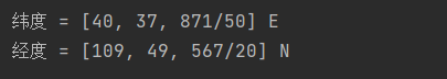
我们得到了一个简易的gps地址
如果想要读取全部的拍摄信息:
# 读取照片的GPS经纬度信息
def find_GPS_image(pic_path):
        GPS = {}
        date = ''
        with open(pic_path, 'rb') as f:
                tags = exifread.process_file(f)
                for tag, value in tags.items():
                        # 纬度
                        if re.match('GPS GPSLatitudeRef', tag):
                                GPS['GPSLatitudeRef'] = str(value)
                        # 经度
                        elif re.match('GPS GPSLongitudeRef', tag):
                                GPS['GPSLongitudeRef'] = str(value)
                        # 海拔
                        elif re.match('GPS GPSAltitudeRef', tag):
                                GPS['GPSAltitudeRef'] = str(value)
                        elif re.match('GPS GPSLatitude', tag):
                                try:
                                        match_result = re.match('\[(\w*),(\w*),(\w.*)/(\w.*)\]', str(value)).groups()
                                        GPS['GPSLatitude'] = int(match_result[0]), int(match_result[1]), int(match_result[2])
                                except:
                                        deg, min, sec = [x.replace(' ', '') for x in str(value)[1:-1].split(',')]
                                        GPS['GPSLatitude'] = latitude_and_longitude_convert_to_decimal_system(deg, min, sec)
                        elif re.match('GPS GPSLongitude', tag):
                                try:
                                        match_result = re.match('\[(\w*),(\w*),(\w.*)/(\w.*)\]', str(value)).groups()
                                        GPS['GPSLongitude'] = int(match_result[0]), int(match_result[1]), int(match_result[2])
                                except:
                                        deg, min, sec = [x.replace(' ', '') for x in str(value)[1:-1].split(',')]
                                        GPS['GPSLongitude'] = latitude_and_longitude_convert_to_decimal_system(deg, min, sec)
                        elif re.match('GPS GPSAltitude', tag):
                                GPS['GPSAltitude'] = str(value)
                        elif re.match('.*Date.*', tag):
                                date = str(value)
return {'GPS_information': GPS, 'date_information': date}2.通过baidu Map的API将GPS信息转换成地址。
众所周知gps和百度的经纬度会有误差,那么我们需要调用百度转换接口,这个百度目前没有开源。
# 通过baidu Map的API将GPS信息转换成地址。
def find_address_from_GPS(GPS):
        """
        使用Geocoding API把经纬度坐标转换为结构化地址。
        :param GPS:
        :return:
        """
        secret_k ey = 'XXX'
        if not GPS['GPS_information']:
                return '该照片无GPS信息'
        lat, lng = GPS['GPS_information']['GPSLatitude'], GPS['GPS_information']['GPSLongitude']
        baidu_map_api = "http://api.map.baidu.com/geocoder/v2/?ak={0}&callback=renderReverse&location={1},{2}s&output=json&pois=0".format(
                secret_key, lat, lng)
        response = requests.get(baidu_map_api)
        content = response.text.replace("renderReverse&&renderReverse(", "")[:-1]
        print(content)
        baidu_map_address = json.loads(content)
        formatted_address = baidu_map_address["result"]["formatted_address"]
        province = baidu_map_address["result"]["addressComponent"]["province"]
        city = baidu_map_address["result"]["addressComponent"]["city"]
        district = baidu_map_address["result"]["addressComponent"]["district"]
        location = baidu_map_address["result"]["sematic_description"]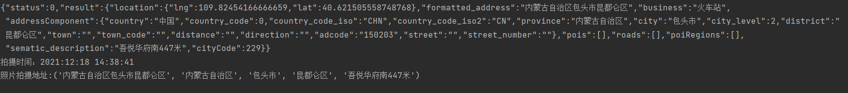
return formatted_address, province, city, district, location然后在主函数输出:
二.源码附上!!!
# coding=utf-8
import exifread
import re
import json
import requests
import os


# 转换经纬度格式
def latitude_and_longitude_convert_to_decimal_system(*arg):
        """
        经纬度转为小数, param arg:
        :return: 十进制小数
        """
        return float(arg[0]) + ((float(arg[1]) + (float(arg[2].split('/')[0]) / float(arg[2].split('/')[-1]) / 60)) / 60)


# 读取照片的GPS经纬度信息
def find_GPS_image(pic_path):
        GPS = {}
        date = ''
        with open(pic_path, 'rb') as f:
                tags = exifread.process_file(f)
                for tag, value in tags.items():
                        # 纬度
                        if re.match('GPS GPSLatitudeRef', tag):
                                GPS['GPSLatitudeRef'] = str(value)
                        # 经度
                        elif re.match('GPS GPSLongitudeRef', tag):
                                GPS['GPSLongitudeRef'] = str(value)
                        # 海拔
                        elif re.match('GPS GPSAltitudeRef', tag):
                                GPS['GPSAltitudeRef'] = str(value)
                        elif re.match('GPS GPSLatitude', tag):
                                try:
                                        match_result = re.match('\[(\w*),(\w*),(\w.*)/(\w.*)\]', str(value)).groups()
                                        GPS['GPSLatitude'] = int(match_result[0]), int(match_result[1]), int(match_result[2])
                                except:
                                        deg, min, sec = [x.replace(' ', '') for x in str(value)[1:-1].split(',')]
                                        GPS['GPSLatitude'] = latitude_and_longitude_convert_to_decimal_system(deg, min, sec)
                        elif re.match('GPS GPSLongitude', tag):
                                try:
                                        match_result = re.match('\[(\w*),(\w*),(\w.*)/(\w.*)\]', str(value)).groups()
                                        GPS['GPSLongitude'] = int(match_result[0]), int(match_result[1]), int(match_result[2])
                                except:
                                        deg, min, sec = [x.replace(' ', '') for x in str(value)[1:-1].split(',')]
                                        GPS['GPSLongitude'] = latitude_and_longitude_convert_to_decimal_system(deg, min, sec)
                        elif re.match('GPS GPSAltitude', tag):
                                GPS['GPSAltitude'] = str(value)
                        elif re.match('.*Date.*', tag):
                                date = str(value)
        return {'GPS_information': GPS, 'date_information': date}


# 通过baidu Map的API将GPS信息转换成地址。
def find_address_from_GPS(GPS):
        """
        使用Geocoding API把经纬度坐标转换为结构化地址。
        :param GPS:
        :return:
        """
        secret_ke y = 'zbLsuDDL4CS2U0M4KezOZZbGUY9iWtVf'
        if not GPS['GPS_information']:
                return '该照片无GPS信息'
        lat, lng = GPS['GPS_information']['GPSLatitude'], GPS['GPS_information']['GPSLongitude']
        baidu_map_api = "http://api.map.baidu.com/geocoder/v2/?ak={0}&callback=renderReverse&location={1},{2}s&output=json&pois=0".format(
                secret_key, lat, lng)
        response = requests.get(baidu_map_api)
        content = response.text.replace("renderReverse&&renderReverse(", "")[:-1]
        print(content)
        baidu_map_address = json.loads(content)
        formatted_address = baidu_map_address["result"]["formatted_address"]
        province = baidu_map_address["result"]["addressComponent"]["province"]
        city = baidu_map_address["result"]["addressComponent"]["city"]
        district = baidu_map_address["result"]["addressComponent"]["district"]
        location = baidu_map_address["result"]["sematic_description"]
        return formatted_address, province, city, district, location

if __name__ == '__main__':
        GPS_info = find_GPS_image(pic_path='小朱学长.jpg')
        address = find_address_from_GPS(GPS=GPS_info)
        print("拍摄时间:" + GPS_info.get("date_information"))
print('照片拍摄地址:' + str(address))注意事项
1.照片的地址信息等,一般的手机相机默认是打开的。
2.微信和QQ里面发送原图,信息都会完整的保留下来。
3.代码里面需要处理在照片我放到了代码的同文件夹下,所以没有写路径,大家可以自己写路径,或者放到于代码相同的路径下即可。
위 내용은 Python을 사용하여 사진 촬영 시 자세한 위치를 얻는 방법의 상세 내용입니다. 자세한 내용은 PHP 중국어 웹사이트의 기타 관련 기사를 참조하세요!

핫 AI 도구

Undresser.AI Undress
사실적인 누드 사진을 만들기 위한 AI 기반 앱

AI Clothes Remover
사진에서 옷을 제거하는 온라인 AI 도구입니다.

Undress AI Tool
무료로 이미지를 벗다

Clothoff.io
AI 옷 제거제

Video Face Swap
완전히 무료인 AI 얼굴 교환 도구를 사용하여 모든 비디오의 얼굴을 쉽게 바꾸세요!

인기 기사
뜨거운 도구

메모장++7.3.1
사용하기 쉬운 무료 코드 편집기

SublimeText3 중국어 버전
중국어 버전, 사용하기 매우 쉽습니다.

스튜디오 13.0.1 보내기
강력한 PHP 통합 개발 환경

드림위버 CS6
시각적 웹 개발 도구

SublimeText3 Mac 버전
신 수준의 코드 편집 소프트웨어(SublimeText3)


 PHP와 Python : 다른 패러다임이 설명되었습니다
Apr 18, 2025 am 12:26 AM
PHP와 Python : 다른 패러다임이 설명되었습니다
Apr 18, 2025 am 12:26 AM
PHP는 주로 절차 적 프로그래밍이지만 객체 지향 프로그래밍 (OOP)도 지원합니다. Python은 OOP, 기능 및 절차 프로그래밍을 포함한 다양한 패러다임을 지원합니다. PHP는 웹 개발에 적합하며 Python은 데이터 분석 및 기계 학습과 같은 다양한 응용 프로그램에 적합합니다.
 PHP와 Python 중에서 선택 : 가이드
Apr 18, 2025 am 12:24 AM
PHP와 Python 중에서 선택 : 가이드
Apr 18, 2025 am 12:24 AM
PHP는 웹 개발 및 빠른 프로토 타이핑에 적합하며 Python은 데이터 과학 및 기계 학습에 적합합니다. 1.PHP는 간단한 구문과 함께 동적 웹 개발에 사용되며 빠른 개발에 적합합니다. 2. Python은 간결한 구문을 가지고 있으며 여러 분야에 적합하며 강력한 라이브러리 생태계가 있습니다.
 PHP와 Python : 그들의 역사에 깊은 다이빙
Apr 18, 2025 am 12:25 AM
PHP와 Python : 그들의 역사에 깊은 다이빙
Apr 18, 2025 am 12:25 AM
PHP는 1994 년에 시작되었으며 Rasmuslerdorf에 의해 개발되었습니다. 원래 웹 사이트 방문자를 추적하는 데 사용되었으며 점차 서버 측 스크립팅 언어로 진화했으며 웹 개발에 널리 사용되었습니다. Python은 1980 년대 후반 Guidovan Rossum에 의해 개발되었으며 1991 년에 처음 출시되었습니다. 코드 가독성과 단순성을 강조하며 과학 컴퓨팅, 데이터 분석 및 기타 분야에 적합합니다.
 Python vs. JavaScript : 학습 곡선 및 사용 편의성
Apr 16, 2025 am 12:12 AM
Python vs. JavaScript : 학습 곡선 및 사용 편의성
Apr 16, 2025 am 12:12 AM
Python은 부드러운 학습 곡선과 간결한 구문으로 초보자에게 더 적합합니다. JavaScript는 가파른 학습 곡선과 유연한 구문으로 프론트 엔드 개발에 적합합니다. 1. Python Syntax는 직관적이며 데이터 과학 및 백엔드 개발에 적합합니다. 2. JavaScript는 유연하며 프론트 엔드 및 서버 측 프로그래밍에서 널리 사용됩니다.
 숭고한 코드 파이썬을 실행하는 방법
Apr 16, 2025 am 08:48 AM
숭고한 코드 파이썬을 실행하는 방법
Apr 16, 2025 am 08:48 AM
Sublime 텍스트로 Python 코드를 실행하려면 먼저 Python 플러그인을 설치 한 다음 .py 파일을 작성하고 코드를 작성한 다음 CTRL B를 눌러 코드를 실행하면 콘솔에 출력이 표시됩니다.
 vscode에서 코드를 작성하는 위치
Apr 15, 2025 pm 09:54 PM
vscode에서 코드를 작성하는 위치
Apr 15, 2025 pm 09:54 PM
Visual Studio Code (VSCODE)에서 코드를 작성하는 것은 간단하고 사용하기 쉽습니다. vscode를 설치하고, 프로젝트를 만들고, 언어를 선택하고, 파일을 만들고, 코드를 작성하고, 저장하고 실행합니다. VSCODE의 장점에는 크로스 플랫폼, 무료 및 오픈 소스, 강력한 기능, 풍부한 확장 및 경량 및 빠른가 포함됩니다.
 Python에서 비주얼 스튜디오 코드를 사용할 수 있습니다
Apr 15, 2025 pm 08:18 PM
Python에서 비주얼 스튜디오 코드를 사용할 수 있습니다
Apr 15, 2025 pm 08:18 PM
VS 코드는 파이썬을 작성하는 데 사용될 수 있으며 파이썬 애플리케이션을 개발하기에 이상적인 도구가되는 많은 기능을 제공합니다. 사용자는 다음을 수행 할 수 있습니다. Python 확장 기능을 설치하여 코드 완료, 구문 강조 및 디버깅과 같은 기능을 얻습니다. 디버거를 사용하여 코드를 단계별로 추적하고 오류를 찾아 수정하십시오. 버전 제어를 위해 git을 통합합니다. 코드 서식 도구를 사용하여 코드 일관성을 유지하십시오. 라인 도구를 사용하여 잠재적 인 문제를 미리 발견하십시오.
 메모장으로 파이썬을 실행하는 방법
Apr 16, 2025 pm 07:33 PM
메모장으로 파이썬을 실행하는 방법
Apr 16, 2025 pm 07:33 PM
메모장에서 Python 코드를 실행하려면 Python 실행 파일 및 NPPEXEC 플러그인을 설치해야합니다. Python을 설치하고 경로를 추가 한 후 nppexec 플러그인의 명령 "Python"및 매개 변수 "{current_directory} {file_name}"을 구성하여 Notepad의 단축키 "F6"을 통해 Python 코드를 실행하십시오.
