
Hai, Dalam blog sebelum ini kita bercakap tentang bagaimana kita boleh melakukan analisis raster menggunakan indeks h3 dan postgresql untuk raster jalur tunggal. Dalam blog ini kita akan bercakap tentang bagaimana kita boleh memproses raster berbilang jalur dan mencipta indeks dengan mudah. Kami akan menggunakan imej sentinel-2 dan mencipta NDVI daripada sel h3 yang diproses dan memvisualisasikan hasilnya
Kami sedang memuat turun data sentinel 2 daripada https://apps.sentinel-hub.com/eo-browser/ di Pokhara, Kawasan Nepal , Hanya untuk memastikan tasik berada dalam grid imej supaya mudah untuk kami untuk mengesahkan keputusan NDVI
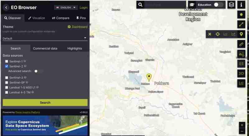
Untuk memuat turun imej sentinel dengan semua kumpulan :
 pada bar menegak kanan
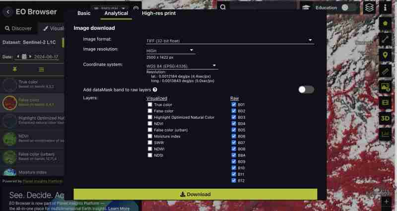
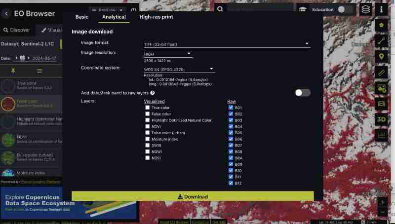
Anda juga boleh memuat turun indeks prajana seperti NDVI, False color tiff sahaja atau jalur tertentu mengikut mana yang paling sesuai dengan keperluan anda. Kami sedang memuat turun semua band kerana kami ingin melakukan pemprosesan sendiri
Kami mendapat semua band sebagai tiff yang berasingan daripada sentinel semasa kami memuat turun format mentah
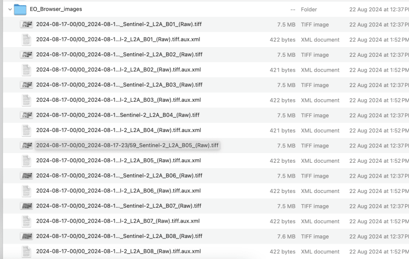
Ini boleh dilakukan melalui alat GIS atau gdal
Kami perlu menamakan semula fail yang dimuat turun kepada band1,band2 seperti ini untuk mengelakkan garis miring dalam nama fail
Mari proses sehingga band 9 untuk latihan ini, anda boleh memilih band sebagai keperluan anda
gdal_merge.py -separate -o sentinel2_composite.tif band1.tif band2.tif band3.tif band4.tif band5.tif band6.tif band7.tif band8.tif band9.tif
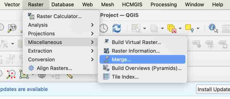
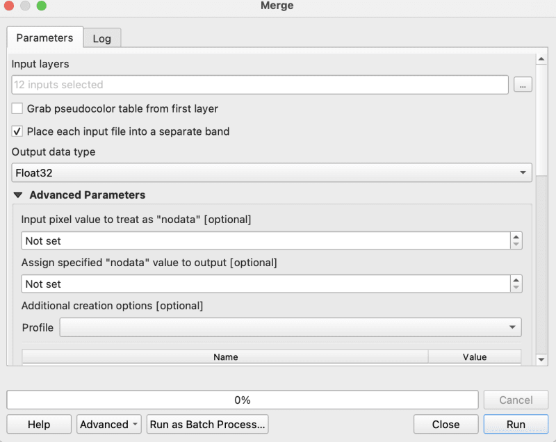
gdalwarp -overwrite -dstnodata 0 "$input_file" "${output_file}_nodata.tif"
gdal_translate -of COG "$input_file" "$output_file"
Saya menggunakan skrip bash yang disediakan dalam repo cog2h3 untuk mengautomasikannya
sudo bash pre.sh sentinel2_composite.tif
Kini akhirnya apabila kita telah melakukan skrip prapemprosesan, mari bergerak ke hadapan untuk mengira sel h3 bagi setiap jalur dalam imej roda komposit
pip install cog2h3
export DATABASE_URL="postgresql://user:password@host:port/database"
Kami menggunakan resolusi 10 untuk imej sentinel ini, namun anda juga akan melihat dalam skrip itu sendiri yang akan mencetak resolusi optimum untuk raster anda yang menjadikan sel h3 lebih kecil daripada piksel terkecil anda dalam raster.
cog2h3 --cog sentinel2_composite_preprocessed.tif --table sentinel --multiband --res 10
Kami mengambil masa seminit untuk mengira dan menyimpan hasil dalam postgresql
Log :
2024-08-24 08:39:43,233 - INFO - Starting processing
2024-08-24 08:39:43,234 - INFO - COG file already exists at sentinel2_composite_preprocessed.tif
2024-08-24 08:39:43,234 - INFO - Processing raster file: sentinel2_composite_preprocessed.tif
2024-08-24 08:39:43,864 - INFO - Determined Min fitting H3 resolution for band 1: 11
2024-08-24 08:39:43,865 - INFO - Resampling original raster to: 200.786148m
2024-08-24 08:39:44,037 - INFO - Resampling Done for band 1
2024-08-24 08:39:44,037 - INFO - New Native H3 resolution for band 1: 10
2024-08-24 08:39:44,738 - INFO - Calculation done for res:10 band:1
2024-08-24 08:39:44,749 - INFO - Determined Min fitting H3 resolution for band 2: 11
2024-08-24 08:39:44,749 - INFO - Resampling original raster to: 200.786148m
2024-08-24 08:39:44,757 - INFO - Resampling Done for band 2
2024-08-24 08:39:44,757 - INFO - New Native H3 resolution for band 2: 10
2024-08-24 08:39:45,359 - INFO - Calculation done for res:10 band:2
2024-08-24 08:39:45,366 - INFO - Determined Min fitting H3 resolution for band 3: 11
2024-08-24 08:39:45,366 - INFO - Resampling original raster to: 200.786148m
2024-08-24 08:39:45,374 - INFO - Resampling Done for band 3
2024-08-24 08:39:45,374 - INFO - New Native H3 resolution for band 3: 10
2024-08-24 08:39:45,986 - INFO - Calculation done for res:10 band:3
2024-08-24 08:39:45,994 - INFO - Determined Min fitting H3 resolution for band 4: 11
2024-08-24 08:39:45,994 - INFO - Resampling original raster to: 200.786148m
2024-08-24 08:39:46,003 - INFO - Resampling Done for band 4
2024-08-24 08:39:46,003 - INFO - New Native H3 resolution for band 4: 10
2024-08-24 08:39:46,605 - INFO - Calculation done for res:10 band:4
2024-08-24 08:39:46,612 - INFO - Determined Min fitting H3 resolution for band 5: 11
2024-08-24 08:39:46,612 - INFO - Resampling original raster to: 200.786148m
2024-08-24 08:39:46,619 - INFO - Resampling Done for band 5
2024-08-24 08:39:46,619 - INFO - New Native H3 resolution for band 5: 10
2024-08-24 08:39:47,223 - INFO - Calculation done for res:10 band:5
2024-08-24 08:39:47,230 - INFO - Determined Min fitting H3 resolution for band 6: 11
2024-08-24 08:39:47,230 - INFO - Resampling original raster to: 200.786148m
2024-08-24 08:39:47,239 - INFO - Resampling Done for band 6
2024-08-24 08:39:47,239 - INFO - New Native H3 resolution for band 6: 10
2024-08-24 08:39:47,829 - INFO - Calculation done for res:10 band:6
2024-08-24 08:39:47,837 - INFO - Determined Min fitting H3 resolution for band 7: 11
2024-08-24 08:39:47,837 - INFO - Resampling original raster to: 200.786148m
2024-08-24 08:39:47,845 - INFO - Resampling Done for band 7
2024-08-24 08:39:47,845 - INFO - New Native H3 resolution for band 7: 10
2024-08-24 08:39:48,445 - INFO - Calculation done for res:10 band:7
2024-08-24 08:39:48,453 - INFO - Determined Min fitting H3 resolution for band 8: 11
2024-08-24 08:39:48,453 - INFO - Resampling original raster to: 200.786148m
2024-08-24 08:39:48,461 - INFO - Resampling Done for band 8
2024-08-24 08:39:48,461 - INFO - New Native H3 resolution for band 8: 10
2024-08-24 08:39:49,046 - INFO - Calculation done for res:10 band:8
2024-08-24 08:39:49,054 - INFO - Determined Min fitting H3 resolution for band 9: 11
2024-08-24 08:39:49,054 - INFO - Resampling original raster to: 200.786148m
2024-08-24 08:39:49,062 - INFO - Resampling Done for band 9
2024-08-24 08:39:49,063 - INFO - New Native H3 resolution for band 9: 10
2024-08-24 08:39:49,647 - INFO - Calculation done for res:10 band:9
2024-08-24 08:39:51,435 - INFO - Converting H3 indices to hex strings
2024-08-24 08:39:51,906 - INFO - Overall raster calculation done in 8 seconds
2024-08-24 08:39:51,906 - INFO - Creating or replacing table sentinel in database
2024-08-24 08:40:03,153 - INFO - Table sentinel created or updated successfully in 11.25 seconds.
2024-08-24 08:40:03,360 - INFO - Processing completed
Memandangkan sekarang kami mempunyai data kami dalam postgresql , Mari buat analisis
select *
from sentinel

explain analyze
select h3_ix , (band8-band4)/(band8+band4) as ndvi
from public.sentinel
Pelan Pertanyaan :
QUERY PLAN                                                                                                       |
-----------------------------------------------------------------------------------------------------------------+
Seq Scan on sentinel  (cost=0.00..28475.41 rows=923509 width=16) (actual time=0.014..155.049 rows=923509 loops=1)|
Planning Time: 0.080 ms                                                                                          |
Execution Time: 183.764 ms                                                                                       |
As you can see here for all the rows in that area the calculation is instant . This is true for all other indices and you can compute complex indices join with other tables using the h3_ix primary key and derive meaningful result out of it without worrying as postgresql is capable of handling complex queries and table join.
Lets visualize and verify if the computed indices are true
create table ndvi_sentinel
as(
select h3_ix , (band8-band4)/(band8+band4) as ndvi
from public.sentinel )
ALTER TABLE ndvi_sentinel
ADD COLUMN geometry geometry(Polygon, 4326)
GENERATED ALWAYS AS (h3_cell_to_boundary_geometry(h3_ix)) STORED;
create index on ndvi_sentinel(geometry);
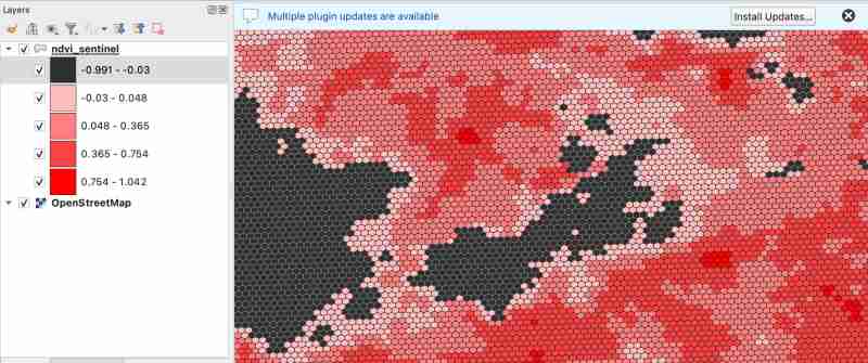
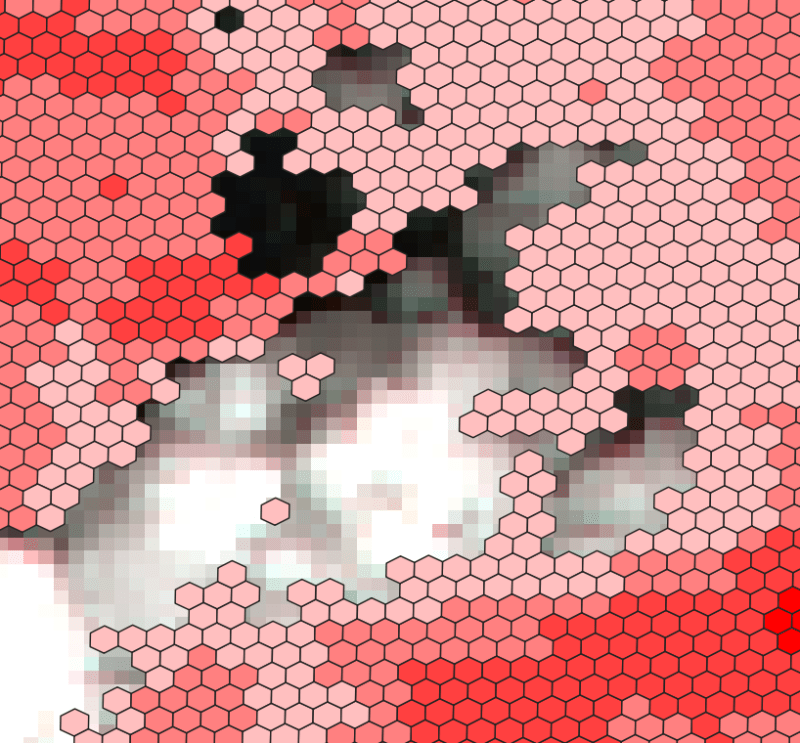
As we know value between -1.0 to 0.1 should represent Deep water or dense clouds
lets see if thats true ( making first category as transparent to see the underlying image )
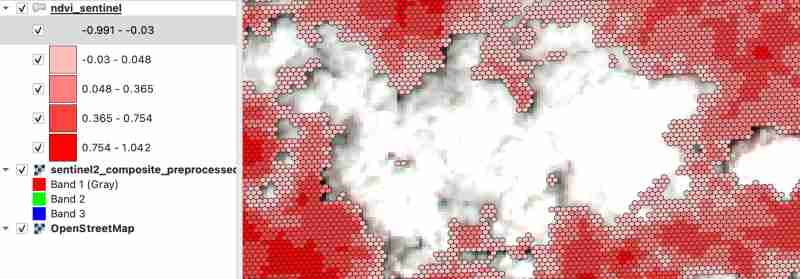
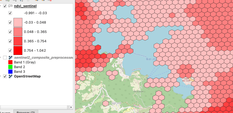
As there were clouds around the lake hence nearby fields are covered by cloud which makes sense
Thank you for reading ! See you in next blog
Atas ialah kandungan terperinci Proses raster berbilang jalur (Sentinel-dengan hndex dan buat indeks. Untuk maklumat lanjut, sila ikut artikel berkaitan lain di laman web China PHP!
 tambah penggunaan
 Apakah itu CONNECTION_REFUSED
 apakah alamat mac
 Apakah perisian kilat?
 Perkara yang perlu dilakukan jika token log masuk tidak sah
 Bagaimana untuk memaparkan html di tengah
 Apakah kelemahan tomcat biasa?
 Bagaimana untuk memadam alamat WeChat saya
 Bagaimana untuk memuat turun fail flv


