

怎麼用python取得到照片拍攝時的詳細位置

一.引言
我们的朋友给我们发来一张照片我们如何获取到她的位置呢?
用手机拍照会带着GPS信息,原来没注意过这个,因此查看下并使用代码获取照片里的GPS信息
查看图片文件属性
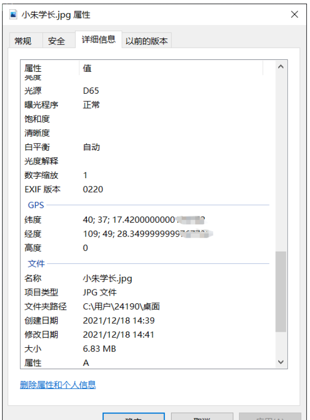
1.读取照片信息,获取坐标
ExifRead
Python library to extract EXIF data from tiff and jpeg files.
安装
pip install exifread
读取GPS
import exifread
import re

def read():
    GPS = {}
    date = ''
    f = open("C:\\Users\\24190\\Desktop\\小朱学长.jpg",'rb')
    contents = exifread.process_file(f)
    for key in contents:
        if key == "GPS GPSLongitude":
            print("经度 =", contents[key],contents['GPS GPSLatitudeRef'])
        elif key =="GPS GPSLatitude":
            print("纬度 =",contents[key],contents['GPS GPSLongitudeRef'])
        #print(contents)
read()运行

我们得到了一个简易的gps地址
如果想要读取全部的拍摄信息:
# 读取照片的GPS经纬度信息
def find_GPS_image(pic_path):
        GPS = {}
        date = ''
        with open(pic_path, 'rb') as f:
                tags = exifread.process_file(f)
                for tag, value in tags.items():
                        # 纬度
                        if re.match('GPS GPSLatitudeRef', tag):
                                GPS['GPSLatitudeRef'] = str(value)
                        # 经度
                        elif re.match('GPS GPSLongitudeRef', tag):
                                GPS['GPSLongitudeRef'] = str(value)
                        # 海拔
                        elif re.match('GPS GPSAltitudeRef', tag):
                                GPS['GPSAltitudeRef'] = str(value)
                        elif re.match('GPS GPSLatitude', tag):
                                try:
                                        match_result = re.match('\[(\w*),(\w*),(\w.*)/(\w.*)\]', str(value)).groups()
                                        GPS['GPSLatitude'] = int(match_result[0]), int(match_result[1]), int(match_result[2])
                                except:
                                        deg, min, sec = [x.replace(' ', '') for x in str(value)[1:-1].split(',')]
                                        GPS['GPSLatitude'] = latitude_and_longitude_convert_to_decimal_system(deg, min, sec)
                        elif re.match('GPS GPSLongitude', tag):
                                try:
                                        match_result = re.match('\[(\w*),(\w*),(\w.*)/(\w.*)\]', str(value)).groups()
                                        GPS['GPSLongitude'] = int(match_result[0]), int(match_result[1]), int(match_result[2])
                                except:
                                        deg, min, sec = [x.replace(' ', '') for x in str(value)[1:-1].split(',')]
                                        GPS['GPSLongitude'] = latitude_and_longitude_convert_to_decimal_system(deg, min, sec)
                        elif re.match('GPS GPSAltitude', tag):
                                GPS['GPSAltitude'] = str(value)
                        elif re.match('.*Date.*', tag):
                                date = str(value)
return {'GPS_information': GPS, 'date_information': date}2.通过baidu Map的API将GPS信息转换成地址。
众所周知gps和百度的经纬度会有误差,那么我们需要调用百度转换接口,这个百度目前没有开源。
# 通过baidu Map的API将GPS信息转换成地址。
def find_address_from_GPS(GPS):
        """
        使用Geocoding API把经纬度坐标转换为结构化地址。
        :param GPS:
        :return:
        """
        secret_k ey = 'XXX'
        if not GPS['GPS_information']:
                return '该照片无GPS信息'
        lat, lng = GPS['GPS_information']['GPSLatitude'], GPS['GPS_information']['GPSLongitude']
        baidu_map_api = "http://api.map.baidu.com/geocoder/v2/?ak={0}&callback=renderReverse&location={1},{2}s&output=json&pois=0".format(
                secret_key, lat, lng)
        response = requests.get(baidu_map_api)
        content = response.text.replace("renderReverse&&renderReverse(", "")[:-1]
        print(content)
        baidu_map_address = json.loads(content)
        formatted_address = baidu_map_address["result"]["formatted_address"]
        province = baidu_map_address["result"]["addressComponent"]["province"]
        city = baidu_map_address["result"]["addressComponent"]["city"]
        district = baidu_map_address["result"]["addressComponent"]["district"]
        location = baidu_map_address["result"]["sematic_description"]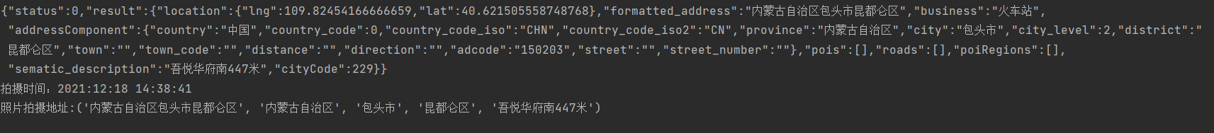
return formatted_address, province, city, district, location然后在主函数输出:
二.源码附上!!!
# coding=utf-8
import exifread
import re
import json
import requests
import os


# 转换经纬度格式
def latitude_and_longitude_convert_to_decimal_system(*arg):
        """
        经纬度转为小数, param arg:
        :return: 十进制小数
        """
        return float(arg[0]) + ((float(arg[1]) + (float(arg[2].split('/')[0]) / float(arg[2].split('/')[-1]) / 60)) / 60)


# 读取照片的GPS经纬度信息
def find_GPS_image(pic_path):
        GPS = {}
        date = ''
        with open(pic_path, 'rb') as f:
                tags = exifread.process_file(f)
                for tag, value in tags.items():
                        # 纬度
                        if re.match('GPS GPSLatitudeRef', tag):
                                GPS['GPSLatitudeRef'] = str(value)
                        # 经度
                        elif re.match('GPS GPSLongitudeRef', tag):
                                GPS['GPSLongitudeRef'] = str(value)
                        # 海拔
                        elif re.match('GPS GPSAltitudeRef', tag):
                                GPS['GPSAltitudeRef'] = str(value)
                        elif re.match('GPS GPSLatitude', tag):
                                try:
                                        match_result = re.match('\[(\w*),(\w*),(\w.*)/(\w.*)\]', str(value)).groups()
                                        GPS['GPSLatitude'] = int(match_result[0]), int(match_result[1]), int(match_result[2])
                                except:
                                        deg, min, sec = [x.replace(' ', '') for x in str(value)[1:-1].split(',')]
                                        GPS['GPSLatitude'] = latitude_and_longitude_convert_to_decimal_system(deg, min, sec)
                        elif re.match('GPS GPSLongitude', tag):
                                try:
                                        match_result = re.match('\[(\w*),(\w*),(\w.*)/(\w.*)\]', str(value)).groups()
                                        GPS['GPSLongitude'] = int(match_result[0]), int(match_result[1]), int(match_result[2])
                                except:
                                        deg, min, sec = [x.replace(' ', '') for x in str(value)[1:-1].split(',')]
                                        GPS['GPSLongitude'] = latitude_and_longitude_convert_to_decimal_system(deg, min, sec)
                        elif re.match('GPS GPSAltitude', tag):
                                GPS['GPSAltitude'] = str(value)
                        elif re.match('.*Date.*', tag):
                                date = str(value)
        return {'GPS_information': GPS, 'date_information': date}


# 通过baidu Map的API将GPS信息转换成地址。
def find_address_from_GPS(GPS):
        """
        使用Geocoding API把经纬度坐标转换为结构化地址。
        :param GPS:
        :return:
        """
        secret_ke y = 'zbLsuDDL4CS2U0M4KezOZZbGUY9iWtVf'
        if not GPS['GPS_information']:
                return '该照片无GPS信息'
        lat, lng = GPS['GPS_information']['GPSLatitude'], GPS['GPS_information']['GPSLongitude']
        baidu_map_api = "http://api.map.baidu.com/geocoder/v2/?ak={0}&callback=renderReverse&location={1},{2}s&output=json&pois=0".format(
                secret_key, lat, lng)
        response = requests.get(baidu_map_api)
        content = response.text.replace("renderReverse&&renderReverse(", "")[:-1]
        print(content)
        baidu_map_address = json.loads(content)
        formatted_address = baidu_map_address["result"]["formatted_address"]
        province = baidu_map_address["result"]["addressComponent"]["province"]
        city = baidu_map_address["result"]["addressComponent"]["city"]
        district = baidu_map_address["result"]["addressComponent"]["district"]
        location = baidu_map_address["result"]["sematic_description"]
        return formatted_address, province, city, district, location

if __name__ == '__main__':
        GPS_info = find_GPS_image(pic_path='小朱学长.jpg')
        address = find_address_from_GPS(GPS=GPS_info)
        print("拍摄时间:" + GPS_info.get("date_information"))
print('照片拍摄地址:' + str(address))注意事项
1.照片的地址信息等,一般的手机相机默认是打开的。
2.微信和QQ里面发送原图,信息都会完整的保留下来。
3.代码里面需要处理在照片我放到了代码的同文件夹下,所以没有写路径,大家可以自己写路径,或者放到于代码相同的路径下即可。
以上是怎麼用python取得到照片拍攝時的詳細位置的詳細內容。更多資訊請關注PHP中文網其他相關文章!

熱AI工具

Undresser.AI Undress
人工智慧驅動的應用程序,用於創建逼真的裸體照片

AI Clothes Remover
用於從照片中去除衣服的線上人工智慧工具。

Undress AI Tool
免費脫衣圖片

Clothoff.io
AI脫衣器

AI Hentai Generator
免費產生 AI 無盡。

熱門文章
熱工具

記事本++7.3.1
好用且免費的程式碼編輯器

SublimeText3漢化版
中文版,非常好用

禪工作室 13.0.1
強大的PHP整合開發環境

Dreamweaver CS6
視覺化網頁開發工具

SublimeText3 Mac版
神級程式碼編輯軟體(SublimeText3)
熱門話題


 mysql 是否要付費
Apr 08, 2025 pm 05:36 PM
mysql 是否要付費
Apr 08, 2025 pm 05:36 PM
MySQL 有免費的社區版和收費的企業版。社區版可免費使用和修改,但支持有限,適合穩定性要求不高、技術能力強的應用。企業版提供全面商業支持,適合需要穩定可靠、高性能數據庫且願意為支持買單的應用。選擇版本時考慮的因素包括應用關鍵性、預算和技術技能。沒有完美的選項,只有最合適的方案,需根據具體情況謹慎選擇。
 HadiDB:Python 中的輕量級、可水平擴展的數據庫
Apr 08, 2025 pm 06:12 PM
HadiDB:Python 中的輕量級、可水平擴展的數據庫
Apr 08, 2025 pm 06:12 PM
HadiDB:輕量級、高水平可擴展的Python數據庫HadiDB(hadidb)是一個用Python編寫的輕量級數據庫,具備高度水平的可擴展性。安裝HadiDB使用pip安裝:pipinstallhadidb用戶管理創建用戶:createuser()方法創建一個新用戶。 authentication()方法驗證用戶身份。 fromhadidb.operationimportuseruser_obj=user("admin","admin")user_obj.
 Navicat查看MongoDB數據庫密碼的方法
Apr 08, 2025 pm 09:39 PM
Navicat查看MongoDB數據庫密碼的方法
Apr 08, 2025 pm 09:39 PM
直接通過 Navicat 查看 MongoDB 密碼是不可能的,因為它以哈希值形式存儲。取回丟失密碼的方法:1. 重置密碼;2. 檢查配置文件(可能包含哈希值);3. 檢查代碼(可能硬編碼密碼)。
 如何針對高負載應用程序優化 MySQL 性能?
Apr 08, 2025 pm 06:03 PM
如何針對高負載應用程序優化 MySQL 性能?
Apr 08, 2025 pm 06:03 PM
MySQL數據庫性能優化指南在資源密集型應用中,MySQL數據庫扮演著至關重要的角色,負責管理海量事務。然而,隨著應用規模的擴大,數據庫性能瓶頸往往成為製約因素。本文將探討一系列行之有效的MySQL性能優化策略,確保您的應用在高負載下依然保持高效響應。我們將結合實際案例,深入講解索引、查詢優化、數據庫設計以及緩存等關鍵技術。 1.數據庫架構設計優化合理的數據庫架構是MySQL性能優化的基石。以下是一些核心原則:選擇合適的數據類型選擇最小的、符合需求的數據類型,既能節省存儲空間,又能提升數據處理速度
 Python:探索其主要應用程序
Apr 10, 2025 am 09:41 AM
Python:探索其主要應用程序
Apr 10, 2025 am 09:41 AM
Python在web開發、數據科學、機器學習、自動化和腳本編寫等領域有廣泛應用。 1)在web開發中,Django和Flask框架簡化了開發過程。 2)數據科學和機器學習領域,NumPy、Pandas、Scikit-learn和TensorFlow庫提供了強大支持。 3)自動化和腳本編寫方面,Python適用於自動化測試和系統管理等任務。
 如何將 AWS Glue 爬網程序與 Amazon Athena 結合使用
Apr 09, 2025 pm 03:09 PM
如何將 AWS Glue 爬網程序與 Amazon Athena 結合使用
Apr 09, 2025 pm 03:09 PM
作為數據專業人員,您需要處理來自各種來源的大量數據。這可能會給數據管理和分析帶來挑戰。幸運的是,兩項 AWS 服務可以提供幫助:AWS Glue 和 Amazon Athena。
 2小時的Python計劃:一種現實的方法
Apr 11, 2025 am 12:04 AM
2小時的Python計劃:一種現實的方法
Apr 11, 2025 am 12:04 AM
2小時內可以學會Python的基本編程概念和技能。 1.學習變量和數據類型,2.掌握控制流(條件語句和循環),3.理解函數的定義和使用,4.通過簡單示例和代碼片段快速上手Python編程。
 mysql 可以連接到 sql 服務器嗎
Apr 08, 2025 pm 05:54 PM
mysql 可以連接到 sql 服務器嗎
Apr 08, 2025 pm 05:54 PM
否,MySQL 無法直接連接到 SQL Server。但可以使用以下方法實現數據交互:使用中間件:將數據從 MySQL 導出到中間格式,然後通過中間件導入到 SQL Server。使用數據庫鏈接器:商業工具可提供更友好的界面和高級功能,本質上仍通過中間件方式實現。
